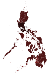
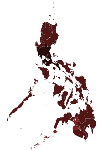
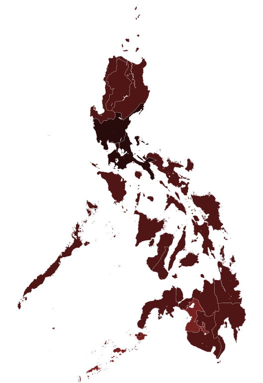
File:COVID-19 pandemic cases in the Philippines by region.svg

Size of this PNG preview of this SVG file: 412 × 599 pixels. Other resolutions: 165 × 240 pixels | 330 × 480 pixels | 528 × 768 pixels | 704 × 1,024 pixels | 1,409 × 2,048 pixels | 4,200 × 6,105 pixels.
Original file (SVG file, nominally 4,200 × 6,105 pixels, file size: 2.02 MB)
Captions
Captions
Add a one-line explanation of what this file represents
Summary edit
| Description |
|
||
| Date | (UTC) | ||
| Source |
This file was derived from: Philippines, administrative divisions - de - colored.svg:  |
||
| Author |
|
||
| Other versions |
|
||
| SVG development |

Licensing edit
I, the copyright holder of this work, hereby publish it under the following licenses:
This file is licensed under the Creative Commons Attribution-Share Alike 3.0 Unported license.
- You are free:
- to share – to copy, distribute and transmit the work
- to remix – to adapt the work
- Under the following conditions:
- attribution – You must give appropriate credit, provide a link to the license, and indicate if changes were made. You may do so in any reasonable manner, but not in any way that suggests the licensor endorses you or your use.
- share alike – If you remix, transform, or build upon the material, you must distribute your contributions under the same or compatible license as the original.

|
Permission is granted to copy, distribute and/or modify this document under the terms of the GNU Free Documentation License, Version 1.2 or any later version published by the Free Software Foundation; with no Invariant Sections, no Front-Cover Texts, and no Back-Cover Texts. A copy of the license is included in the section entitled GNU Free Documentation License. |
You may select the license of your choice.
Original upload log edit
This image is a derivative work of the following images:
- File:Philippines, administrative divisions - de - colored.svg licensed with Cc-by-sa-3.0, GFDL
- 2018-01-31T21:39:34Z Man77 1871x2468 (1801204 Bytes) Reverted to version as of 22:36, 16 August 2012 (UTC) NIR revoked
- 2016-03-25T22:45:38Z Man77 1871x2468 (1854996 Bytes) recolored some island
- 2016-03-25T22:40:52Z Man77 1871x2468 (1854960 Bytes) UPD NIR
- 2012-08-16T22:36:11Z TUBS 1871x2468 (1801204 Bytes) == {{int:filedesc}} == {{Information |Description={{de|Karte der politischen Gliederung von XY (siehe Dateiname)}} {{en|Map of administrative divisions of XY (see filename)}} |Source={{own}}
Uploaded with derivativeFX
File history
Click on a date/time to view the file as it appeared at that time.
| Date/Time | Thumbnail | Dimensions | User | Comment | |
|---|---|---|---|---|---|
| current | 06:10, 6 June 2021 | | 4,200 × 6,105 (2.02 MB) | HueMan1 (talk | contribs) | update |
| 01:57, 25 January 2021 |  | 4,200 × 6,105 (2.02 MB) | HueMan1 (talk | contribs) | Update | |
| 23:09, 15 October 2020 |  | 4,200 × 6,105 (2.02 MB) | Hariboneagle927 (talk | contribs) | Oct 15 | |
| 03:57, 26 August 2020 |  | 4,200 × 6,105 (2.02 MB) | HueMan1 (talk | contribs) | Update | |
| 15:32, 13 August 2020 |  | 4,200 × 6,105 (2.02 MB) | Hariboneagle927 (talk | contribs) | August 13 | |
| 08:13, 17 June 2020 |  | 4,200 × 6,105 (2.02 MB) | Hariboneagle927 (talk | contribs) | update to June 16 as per the revamped DOH COVID-19 tracker https://www.doh.gov.ph/covid19tracker | |
| 09:50, 12 June 2020 |  | 4,200 × 6,105 (2.02 MB) | Hariboneagle927 (talk | contribs) | update to June 10 http://geoportal.gov.ph/gpapps/covidapp | |
| 11:35, 4 June 2020 |  | 4,200 × 6,105 (2.02 MB) | HueMan1 (talk | contribs) | Adjusted colours for 10000+ | |
| 23:29, 22 May 2020 |  | 4,200 × 6,105 (2.02 MB) | Hariboneagle927 (talk | contribs) | May 22 | |
| 17:15, 10 May 2020 |  | 4,200 × 6,105 (2.02 MB) | Hariboneagle927 (talk | contribs) | update May 10 |
You cannot overwrite this file.
File usage on Commons
The following 6 pages use this file:
- File:2019-nCoV Outbreak Cases in the Philippines by region.svg (file redirect)
- File:COVID-19 Outbreak Cases in the Philippines by region.svg (file redirect)
- File:COVID-19 pandemic cases in the Philippines.svg
- File:COVID-19 pandemic cases in the Philippines by region (per capita).svg
- File:COVID-19 pandemic cases in the Philippines version 2.svg
- Category:COVID-19 pandemic in the Philippines
.svg)
File usage on other wikis
The following other wikis use this file:
- Usage on ar.wikipedia.org
- Usage on ca.wikipedia.org
- Usage on eu.wikipedia.org
- Usage on he.wikipedia.org
- Usage on id.wikipedia.org
- Usage on min.wikipedia.org
- Usage on nl.wikipedia.org
- Usage on pt.wikipedia.org
- Usage on www.wikidata.org
- Usage on zh-yue.wikipedia.org