File:Carte d'État-major de la France, Feuille Bourg S.E.jpg

Size of this preview: 800 × 482 pixels. Other resolutions: 320 × 193 pixels | 640 × 385 pixels | 1,024 × 617 pixels | 1,280 × 771 pixels | 2,560 × 1,542 pixels | 22,559 × 13,588 pixels.
Original file (22,559 × 13,588 pixels, file size: 86.09 MB, MIME type: image/jpeg)
Captions
Captions
Add a one-line explanation of what this file represents
Summary
edit
| Warning | The original file is very high-resolution. It might not load properly or could cause your browser to freeze when opened at full size. |
|---|
| Description |
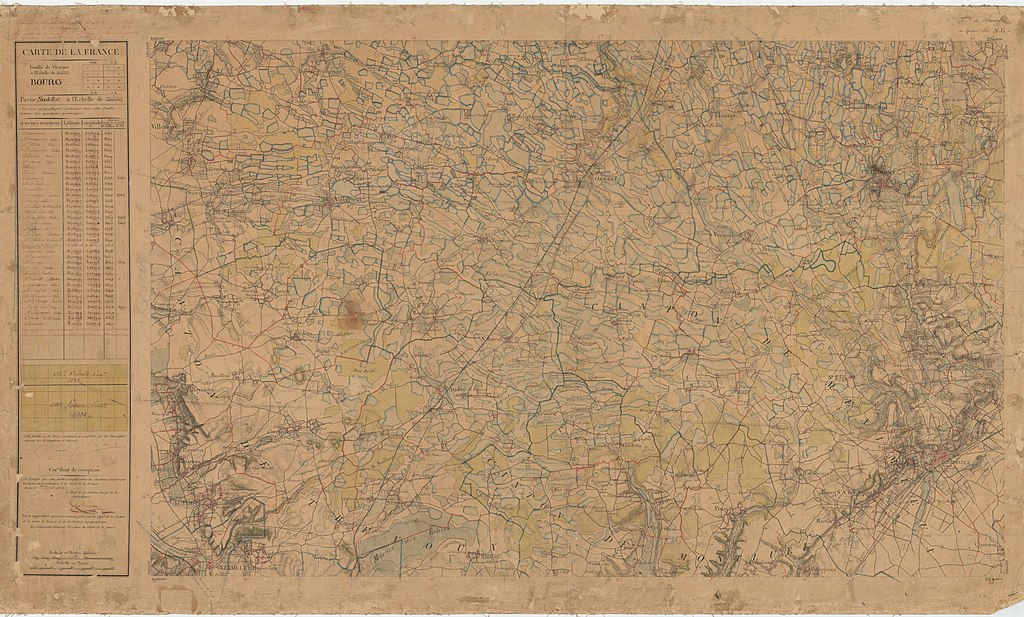
English: Old military map of France, Ain and Rhône departments. Bourg S.E. sheet, 1/40,000.
Français : Carte d'État-major de la France, départements de l'Ain et du Rhône, Feuille Bourg S.E. 1/40 000. |
| Date | |
| Source | IGN, direct link |
| Author | Dépôt de la Guerre (Q1270687) |
Licensing
edit
This work is in the public domain in France for one of the following reasons:
|
 |
This work is in the public domain in the United States because it was published (or registered with the U.S. Copyright Office) before January 1, 1929.
Public domain works must be out of copyright in both the United States and in the source country of the work in order to be hosted on the Commons. If the work is not a U.S. work, the file must have an additional copyright tag indicating the copyright status in the source country.
Note: This tag should not be used for sound recordings. |
File history
Click on a date/time to view the file as it appeared at that time.
| Date/Time | Thumbnail | Dimensions | User | Comment | |
|---|---|---|---|---|---|
| current | 08:19, 23 January 2019 | | 22,559 × 13,588 (86.09 MB) | Yann (talk | contribs) | =={{int:filedesc}}== {{LargeImage}} {{Information |description={{en|1=Old military map of France, Ain and Rhône departments. Bourg S.E. sheet, 1/40,000.}} {{fr|1=Carte d'État-major de la France, départements de l'Ain et du Rhône, Feuille Bourg S.E. 1/40 000.}} |date=1866 |source=[https://remonterletemps.ign.fr/telecharger?x=5.019781&y=45.860987&z=9&layer=GEOGRAPHICALGRIDSYSTEMS.MAPS.SCAN-EXPRESS.STANDARD&demat=ETATMAJOR$GEOPORTAIL:DEMAT IGN], [https://gpp3-wxs.ign.fr/02eikbvn4qqd6y1g5iiiq8fi/... |
You cannot overwrite this file.
File usage on Commons
The following 2 pages use this file: