File:Cernay, Nécropole nationale 1.jpg

Size of this preview: 800 × 545 pixels. Other resolutions: 320 × 218 pixels | 640 × 436 pixels | 1,024 × 698 pixels | 1,280 × 872 pixels | 2,560 × 1,744 pixels | 6,963 × 4,743 pixels.
Original file (6,963 × 4,743 pixels, file size: 5.02 MB, MIME type: image/jpeg)
Captions
Captions
Add a one-line explanation of what this file represents
| Description |
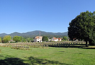
Français : Cimetière militaire de Cernay Deutsch: Friedhof gefallener französischer Soldaten in Cernay |
| Date | |
| Source | Self-photographed |
| Author | Rauenstein |
| Permission (Reusing this file) |
This file is licensed under the Creative Commons Attribution-Share Alike 3.0 Unported license.
|
| Object location | | View this and other nearby images on: OpenStreetMap |
|---|
File history
Click on a date/time to view the file as it appeared at that time.
| Date/Time | Thumbnail | Dimensions | User | Comment | |
|---|---|---|---|---|---|
| current | 10:03, 13 August 2023 | | 6,963 × 4,743 (5.02 MB) | Rauenstein (talk | contribs) | {{Information |Description={{fr|Cimetière militaire de Cernay}} {{de|Friedhof gefallener französischer Soldaten in Cernay}} |Source={{self-photographed}} |Date=2016-03-12 |Author=Rauenstein |Permission={{PD-self}} |other_versions= }} {{Object location|47|48|48.73|N|7|10|43.39|E}} Category:Nécropole nationale de Cernay Category:France photographs taken on 2016-03-12 [[Category:Files by User Rauenstein/France-6... |
| 21:19, 13 March 2016 |  | 4,292 × 2,881 (10.27 MB) | Rauenstein (talk | contribs) | {{Information |Description={{fr|Cimetière militaire de Cernay}} {{de|Friedhof gefallener französischer Soldaten in Cernay}} |Source=own photograph |Date=2016-03-12 |Author=[[User:Rauenstein|Rauens... |
You cannot overwrite this file.
File usage on Commons
The following page uses this file:
File usage on other wikis
The following other wikis use this file:
- Usage on de.wikipedia.org
- Usage on fr.wikipedia.org
- Usage on www.wikidata.org