File:Chet-route01.jpg

Size of this preview: 479 × 599 pixels. Other resolutions: 192 × 240 pixels | 384 × 480 pixels | 956 × 1,196 pixels.
Original file (956 × 1,196 pixels, file size: 367 KB, MIME type: image/jpeg)
Captions
Captions
Add a one-line explanation of what this file represents
Summary edit
| Description |
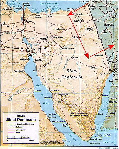
English: The "Chet" route (marked in red arrows) — used by terrorists and smugglers to penetrate into Israel.
עברית: ציר ה-ח' מסומן באדום |
| Date | |
| Source | US Federal government image Image:Sinai-peninsula-map.jpg |
| Author |
MathKnight |
| Permission (Reusing this file) |
{{PD}} |
| Other versions | Image:Sinai-peninsula-map.jpg |
Licensing edit
This work is in the public domain in the United States because it is a work prepared by an officer or employee of the United States Government as part of that person’s official duties under the terms of Title 17, Chapter 1, Section 105 of the US Code.
Note: This only applies to original works of the Federal Government and not to the work of any individual U.S. state, territory, commonwealth, county, municipality, or any other subdivision. This template also does not apply to postage stamp designs published by the United States Postal Service since 1978. (See § 313.6(C)(1) of Compendium of U.S. Copyright Office Practices). It also does not apply to certain US coins; see The US Mint Terms of Use.
|
 | |
| This file has been identified as being free of known restrictions under copyright law, including all related and neighboring rights. | ||
File history
Click on a date/time to view the file as it appeared at that time.
| Date/Time | Thumbnail | Dimensions | User | Comment | |
|---|---|---|---|---|---|
| current | 19:35, 26 January 2008 | | 956 × 1,196 (367 KB) | MathKnight (talk | contribs) | {{Information |Description= The "Chet" route (marked in red arrows): Gaza Strip (Rafah) - Sinai - Iseaeli-Egyptian border, used by terrorists and smugglers to penetrate into Israel ציר ה-ח' מסומן באדום |Source=US Federal gov |
You cannot overwrite this file.
File usage on Commons
There are no pages that use this file.
File usage on other wikis
The following other wikis use this file:
- Usage on he.wikipedia.org