File:ChroicocephalusRidibundusIUCN2019-2.png

Size of this preview: 800 × 393 pixels. Other resolutions: 320 × 157 pixels | 640 × 314 pixels | 1,024 × 503 pixels | 1,280 × 629 pixels | 3,461 × 1,700 pixels.
Original file (3,461 × 1,700 pixels, file size: 1.03 MB, MIME type: image/png)
Captions
Captions
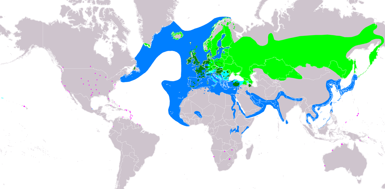
Distribution map of black-headed gull (Chroicocephalus ridibundus)

|
This map of the world image could be re-created using vector graphics as an SVG file. This has several advantages; see Commons:Media for cleanup for more information. If an SVG form of this image is available, please upload it and afterwards replace this template with
{{vector version available|new image name}}.
It is recommended to name the SVG file “ChroicocephalusRidibundusIUCN2019-2.svg”—then the template Vector version available (or Vva) does not need the new image name parameter. |
Summary edit
| Description |
Slovenčina: Mapa rozšírenia druhu čajka smejivá (Chroicocephalus ridibundus) podľa IUCN verzia 2019-2 :
legenda: Hniezdiaca, výskyt v letnom období (#00FF00), Hniezdiaca, celoročný výskyt (#008000), Migrujúca (#00FFFF), Nehniezdiaca (#007FFF), Na potulkách (závislosť na sezóne nejasná) (#FF00FF) English: Distribution map of black-headed gull (Chroicocephalus ridibundus) according to IUCN version 2019-2 ; key: Legend: Extant, breeding (#00FF00), Extant, resident (#008000), Extant, passage (#00FFFF), Extant, non-breeding (#007FFF), Extant & Vagrant (seasonality uncertain) (#FF00FF) |
| Date | |
| Source | Made with Natural Earth. Free vetor and raster map data @ naturalearthdata.com. Range map fromBirdLife International 2018. Larus ridibundus. The IUCN Red List of Threatened Species 2018: e.T22694420A132548687. https://dx.doi.org/10.2305/IUCN.UK.2018-2.RLTS.T22694420A132548687.en. Downloaded on 23 August 2019 as visual indicator of distribution. |
| Author | SanoAK: Alexander Kürthy |
Licensing edit

This file is licensed under the Creative Commons Attribution-Share Alike 3.0 Unported license.
Attribution: IUCN Red List of Threatened Species, species assessors and the authors of the spatial data.
- You are free:
- to share – to copy, distribute and transmit the work
- to remix – to adapt the work
- Under the following conditions:
- attribution – You must give appropriate credit, provide a link to the license, and indicate if changes were made. You may do so in any reasonable manner, but not in any way that suggests the licensor endorses you or your use.
- share alike – If you remix, transform, or build upon the material, you must distribute your contributions under the same or compatible license as the original.
File history
Click on a date/time to view the file as it appeared at that time.
| Date/Time | Thumbnail | Dimensions | User | Comment | |
|---|---|---|---|---|---|
| current | 19:59, 10 September 2021 | | 3,461 × 1,700 (1.03 MB) | MPF (talk | contribs) | More details from Olsen & Larsson, ''Gulls of Europe, Asia and North America'' & additional vagrant locs in Australia & Africa |
| 09:44, 4 September 2019 |  | 3,461 × 1,700 (1.07 MB) | SanoAK (talk | contribs) | added a boundary between water and land | |
| 12:57, 23 August 2019 |  | 3,461 × 1,612 (641 KB) | SanoAK (talk | contribs) | User created page with UploadWizard |
You cannot overwrite this file.
File usage on Commons
The following 2 pages use this file:
File usage on other wikis
The following other wikis use this file:
- Usage on ar.wikipedia.org
- Usage on arz.wikipedia.org
- Usage on ast.wikipedia.org
- Usage on bg.wikipedia.org
- Usage on ca.wikipedia.org
- Usage on ce.wikipedia.org
- Usage on cs.wikipedia.org
- Usage on de.wikipedia.org
- Usage on eo.wikipedia.org
- Usage on es.wikipedia.org
- Usage on eu.wikipedia.org
- Usage on fi.wikipedia.org
- Usage on fy.wikipedia.org
- Usage on ga.wikipedia.org
- Usage on hu.wikipedia.org
- Usage on hy.wikipedia.org
- Usage on nn.wikipedia.org
- Usage on pl.wikipedia.org
- Usage on ru.wikipedia.org
- Usage on sk.wikipedia.org
- Usage on species.wikimedia.org
- Usage on tr.wikipedia.org
- Usage on www.wikidata.org