File:Comparison diagram between Shizuoka and Toyokawa on the Tomei Expressway.svg

Size of this PNG preview of this SVG file: 800 × 363 pixels. Other resolutions: 320 × 145 pixels | 640 × 290 pixels | 1,024 × 465 pixels | 1,280 × 581 pixels | 2,560 × 1,162 pixels | 1,772 × 804 pixels.
Original file (SVG file, nominally 1,772 × 804 pixels, file size: 4.71 MB)
Captions
Captions
Add a one-line explanation of what this file represents
Summary
edit
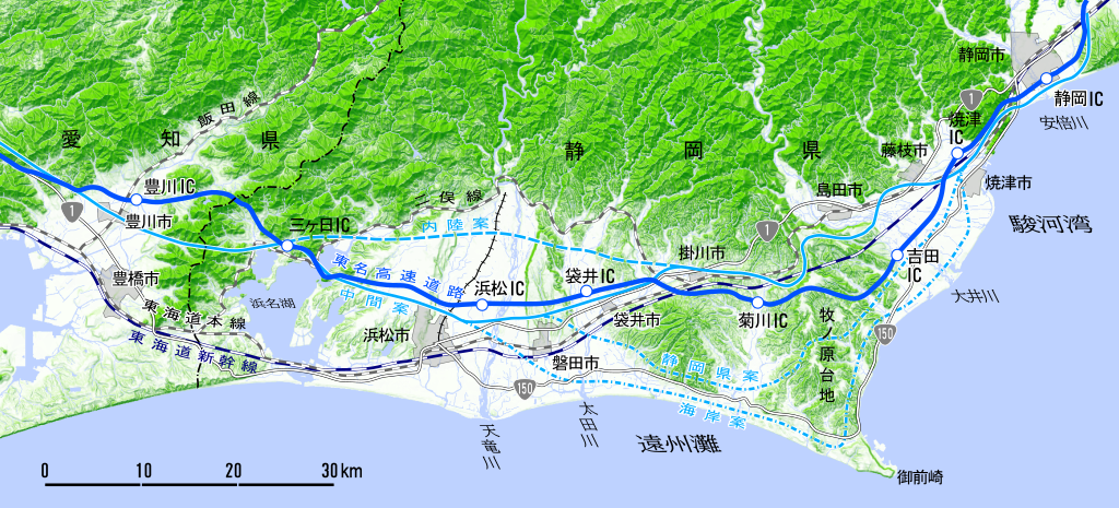
| Description | E1東名高速道路 静岡-豊川間比較線図 |
| Date | |
| Source | 典拠:『東名高速道路』(中公新書188)池上雅夫、16-17頁 |
| Author | 国土地理院・Oka21000 |
Licensing
edit

|
The copyright holder of this file, the Ministry of Land, Infrastructure, Transport and Tourism of Japan, allows anyone to use it for any purpose, provided that the copyright holder is properly attributed. Redistribution, derivative work, commercial use, and all other use is permitted. |
Attribution:
Copyright © National Land Image Information (Color Aerial Photographs), Ministry of Land, Infrastructure, Transport and Tourism
|
 |
This image is copyrighted by the Ministry of Land, Infrastructure, Transport and Tourism of Japan. For terms of use, see the stipulation to use of National Land Information (in Japanese) and message from MLIT (in Japanese and English). When you display this image on an article, include the following phrase in the description: "Made based on National Land Image Information (Color Aerial Photographs), Ministry of Land, Infrastructure, Transport and Tourism".
|
File history
Click on a date/time to view the file as it appeared at that time.
| Date/Time | Thumbnail | Dimensions | User | Comment | |
|---|---|---|---|---|---|
| current | 03:31, 28 November 2021 | | 1,772 × 804 (4.71 MB) | Oka21000 (talk | contribs) | トリミング忘れ |
| 03:28, 28 November 2021 |  | 1,772 × 1,772 (4.71 MB) | Oka21000 (talk | contribs) | {{Information |Description=E1東名高速道路 静岡-豊川間比較線図 |Source=典拠:『東名高速道路』(中公新書188)池上雅夫、16-17頁 |Date=2021-11-28 |Author=国土地理院・Oka21000 |Permission= |other_versions= }} Category:Tomei Expressway in Shizuoka prefecture |
You cannot overwrite this file.
File usage on Commons
There are no pages that use this file.
File usage on other wikis
The following other wikis use this file:
- Usage on ja.wikipedia.org