File:Döbling (Wien) - Gipfelareal des Leopoldsbergs.JPG

Size of this preview: 800 × 450 pixels. Other resolutions: 320 × 180 pixels | 640 × 360 pixels | 1,024 × 576 pixels | 1,280 × 720 pixels | 2,560 × 1,441 pixels | 4,800 × 2,701 pixels.
Original file (4,800 × 2,701 pixels, file size: 9.53 MB, MIME type: image/jpeg)
Captions
Captions
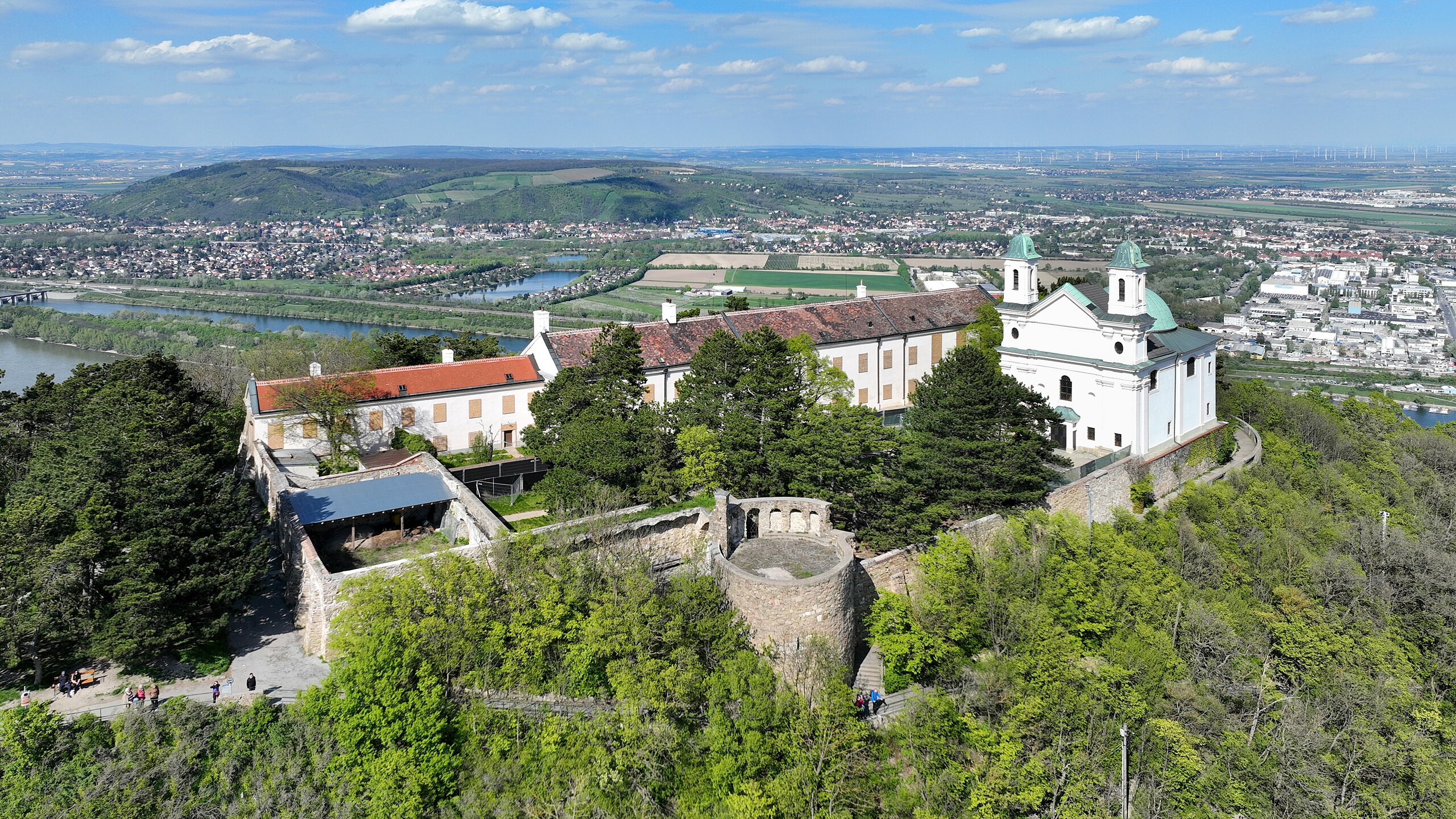
Summit area of the Leopoldsberg in Vienna.
Summary edit
_-_Gipfelareal_des_Leopoldsbergs.JPG&action=edit§ion=1)
| Description |
Deutsch: Das Gipfelplateau des Leopoldsberges von Südwesten aus gesehen mit der Leopoldsbergkirche, dem Heimkehrer-Gedächtnismal und der Leopoldsbergburg und links im Hintergrund der Bisamberg.
Ursprünglich befand sich auf dem Gipfel eine Burg. Am 22. September 1529 wurde die Burg von kaiserlichen Truppen in Brand gesteckt, um sie für die herannahenden Türken als Stützpunkt zu entwerten. In der zweiten Hälfte des 17. Jahrhundert wurde eine Art Schlossgebäude errichtet und 1717 um eine Försterei (heutiger Pfarrhof) und Stallungen (beim heutigen Tor) erweitert wurde: [1]. In den Ruinen der mittelalterlichen Burg ließ Leopold I. 1679 den Grundstein zu einer dem heiligen Leopold geweihten Kapelle legen. Der damalige Bau war ein kleiner Zentralbau mit Kuppel über einem kurzarmigen griechischen Kreuz. In der unvollendeten Kapelle las der päpstliche Legat Marco d'Aviano am 12. September 1683 jene historische Messe, bei der König Jan III. Sobieski ministrierte und der das Entsatzheer auf der heutigen Josefinenwiese beiwohnte. 1717 wurde die Kapelle nach einem Entwurf von Antonio Beduzzi zu einem frühbarocken Kuppelbau mit doppeltürmiger Fassade erweitert bzw. umgebaut: [2]. Das Heimkehrer-Gedächtnismal, nach einem Entwurf von Mario Petrucci 1948 errichtet, wurde im Jahr 2018 zum Teil abgetragen: [3]. English: Summit area of the Leopoldsberg in Vienna. |
| Date | |
| Source | Own work |
| Author | C.Stadler/Bwag |
| Permission (Reusing this file) |
Deutsch: Hallo, du darfst mein Foto kostenlos nutzen, aber nenne mich bitte als Fotograf, beispielsweise „Foto: C.Stadler/Bwag“ oder © C.Stadler/Bwag; CC-BY-SA-4.0. Auf mehr Angaben bestehe ich nicht - im Gegensatz zu manch anderen, die die Vorgaben der unten angeführten Lizenzierung auf Punkt und Beistrich einfordern. English: Feel free to use my photos, but please mention me as the author like © C.Stadler/Bwag or © C.Stadler/Bwag; CC-BY-SA-4.0 (that's good enough) and if you want send me a message: bwag@gmx.net. |
| Object location | | View this and other nearby images on: OpenStreetMap |
|---|
_-_Gipfelareal_des_Leopoldsbergs.JPG¶ms=048.278000_N_0016.346410_E_globe:Earth_class:object_type:object__&language=en)
| Camera location | | View this and other nearby images on: OpenStreetMap |
|---|
_-_Gipfelareal_des_Leopoldsbergs.JPG¶ms=048.277280_N_0016.345360_E_globe:Earth_type:camera_heading:45.00&language=en)
Licensing edit
_-_Gipfelareal_des_Leopoldsbergs.JPG&action=edit§ion=2)
I, the copyright holder of this work, hereby publish it under the following license:
This file is licensed under the Creative Commons Attribution-Share Alike 4.0 International license.
- You are free:
- to share – to copy, distribute and transmit the work
- to remix – to adapt the work
- Under the following conditions:
- attribution – You must give appropriate credit, provide a link to the license, and indicate if changes were made. You may do so in any reasonable manner, but not in any way that suggests the licensor endorses you or your use.
- share alike – If you remix, transform, or build upon the material, you must distribute your contributions under the same or compatible license as the original.
| Annotations | This image is annotated: View the annotations at Commons |
_-_Gipfelareal_des_Leopoldsbergs.JPG)
File history
Click on a date/time to view the file as it appeared at that time.
| Date/Time | Thumbnail | Dimensions | User | Comment | |
|---|---|---|---|---|---|
| current | 20:35, 29 April 2023 | | 4,800 × 2,701 (9.53 MB) | Bwag (talk | contribs) | == {{int:filedesc}} == {{Information |Description= {{de|1=Das Gipfelplateau des Leopoldsberges von Südwesten aus gesehen mit der Leopoldsbergkirche, dem Heimkehrer-Gedächtnismal und der Leopoldsbergburg und links im Hintergrund der Bisamberg.<br/>Ursprünglich befand sich auf dem Gipfel eine Burg. Am 22. September 1529 wurde die Burg von kaiserlichen Truppen in Brand gesteckt, um... |
You cannot overwrite this file.
File usage on Commons
The following 2 pages use this file:
File usage on other wikis
The following other wikis use this file:
- Usage on de.wikipedia.org
- Usage on en.wikipedia.org
- Usage on fr.wikipedia.org
_-_Gipfelareal_des_Leopoldsbergs.JPG&oldid=877964466)