File:Döbling (Wien) - Krapfenwaldlbad.JPG

Size of this preview: 800 × 386 pixels. Other resolutions: 320 × 154 pixels | 640 × 309 pixels | 1,024 × 494 pixels | 1,280 × 617 pixels | 2,560 × 1,235 pixels | 4,762 × 2,297 pixels.
Original file (4,762 × 2,297 pixels, file size: 9.63 MB, MIME type: image/jpeg)
Captions
Captions
Add a one-line explanation of what this file represents
Summary edit
_-_Krapfenwaldlbad.JPG&action=edit§ion=1)
| Description |
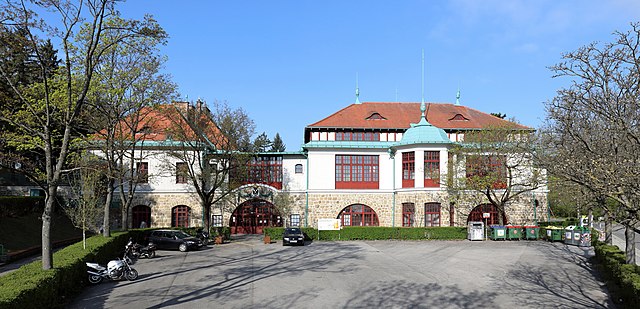
Deutsch: Hauptgebäude des Krapfenwaldlbades im 19. Wiener Bezirk Döbling. Das Gebäude wurde als Volksrestaurant in „Heimatstilbauweise“ an Stelle eines alten Glassalons errichtet und am 30. April 1911 eröffnet. Neben dem Restaurant eröffnete am 17. Juni 1923 die Gemeinde Wien ein Freibad. Nach dem II. WK wurde das Freibad umgebaut, erweitert (Fassungsvermögen 4.500 Personen, Gesamtfläche 44.000 m²) und am 29.Mai 1952 neu eröffnet. Im Zuge dieser Umgestaltung des Freibades wurde das ehemalige Restaurantgebäude in die Badeanlage integriert. |
| Date | |
| Source | Own work |
| Author | C.Stadler/Bwag |
| Permission (Reusing this file) |
Deutsch: Hallo, du darfst mein Foto kostenlos nutzen, aber nenne mich bitte als Fotograf, beispielsweise „Foto: C.Stadler/Bwag“ oder © C.Stadler/Bwag; CC-BY-SA-4.0. Auf mehr Angaben bestehe ich nicht - im Gegensatz zu manch anderen, die die Vorgaben der unten angeführten Lizenzierung auf Punkt und Beistrich einfordern. English: Feel free to use my photos, but please mention me as the author like © C.Stadler/Bwag or © C.Stadler/Bwag; CC-BY-SA-4.0 (that's good enough) and if you want send me a message: bwag@gmx.net. |
| Object location | | View this and other nearby images on: OpenStreetMap |
|---|
_-_Krapfenwaldlbad.JPG¶ms=048.266950_N_0016.330990_E_globe:Earth_class:object_type:object__&language=en)
| Camera location | | View this and other nearby images on: OpenStreetMap |
|---|
_-_Krapfenwaldlbad.JPG¶ms=048.267020_N_0016.331620_E_globe:Earth_type:camera_heading:265.00&language=en)
Licensing edit
_-_Krapfenwaldlbad.JPG&action=edit§ion=2)
I, the copyright holder of this work, hereby publish it under the following license:
This file is licensed under the Creative Commons Attribution-Share Alike 4.0 International license.
- You are free:
- to share – to copy, distribute and transmit the work
- to remix – to adapt the work
- Under the following conditions:
- attribution – You must give appropriate credit, provide a link to the license, and indicate if changes were made. You may do so in any reasonable manner, but not in any way that suggests the licensor endorses you or your use.
- share alike – If you remix, transform, or build upon the material, you must distribute your contributions under the same or compatible license as the original.
File history
Click on a date/time to view the file as it appeared at that time.
| Date/Time | Thumbnail | Dimensions | User | Comment | |
|---|---|---|---|---|---|
| current | 18:26, 17 April 2019 | | 4,762 × 2,297 (9.63 MB) | Bwag (talk | contribs) | r |
| 18:20, 17 April 2019 |  | 4,795 × 2,313 (9.93 MB) | Bwag (talk | contribs) | {{Information |Description= {{de|1= Hauptgebäude des Krapfenwaldlbad im 19. Wiener Bezirk Döbling.<br/>Das Gebäude wurde als Volksrestaurant in „Heimatstilbauweise“ an Stelle eines alten Glassalons errichtet und am 30. April 1911 eröffnet. Neben dem Restaurant wurde am 17. Juni 1923 von der Gemeinde Wien ein Freibad eröffnet. 1952 wurde das Restaurant aufgelassen und das Gebäude zu einem Kabinentrakt für das Freibad umgebaut.}} |Source= {{... |
You cannot overwrite this file.
File usage on Commons
The following 2 pages use this file:
File usage on other wikis
The following other wikis use this file:
- Usage on de.wikipedia.org
- Usage on www.wikidata.org
_-_Krapfenwaldlbad.JPG&oldid=706366228)