File:Desmarest - Carte topographique et minéralogique d'une partie de la Province d'Auvergne - CA 5066.pdf

Size of this JPG preview of this PDF file: 508 × 599 pixels. Other resolutions: 203 × 240 pixels | 407 × 480 pixels | 651 × 768 pixels | 868 × 1,024 pixels | 2,216 × 2,614 pixels.
Original file (2,216 × 2,614 pixels, file size: 21.63 MB, MIME type: application/pdf)
Captions
Captions
Add a one-line explanation of what this file represents
Summary
edit| Description |
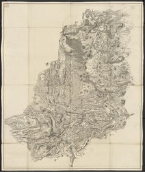
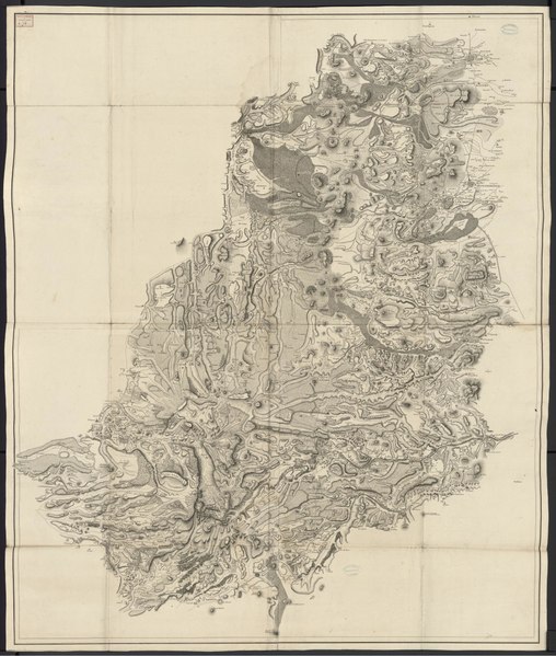
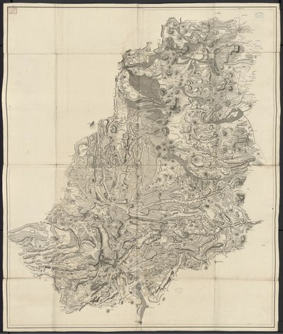
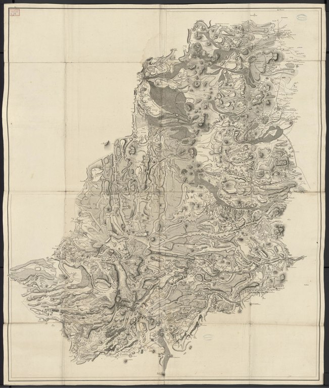
Français : Sont déterminées la Marche et les Limites des matières fondues par les Volcants [sic], ainsi que les courants anciens et modernes. Relative aux Recherches sur l'Histoire Naturelle de cette Province publiées par M. Desmarest Inspecteur des Manufactures. Voir la carte et ses références sur Gallica. |
||
| Date | |||
| Source |
|
||
| Author | Nicolas Desmarest, François Pasumot, Dailley, Guillaume-Nicolas Delahaye |
| Author |
|
 | |||||||||||||||||||
| Illustrator |
|
||||||||||||||||||||
| Title |
French: Carte topographique et minéralogique d'une partie de la Province d'Auvergne où sont déterminées la Marche et les Limites des matières fondues par les Volcants [sic], ainsi que les courants anciens et modernes Clermont-Ferrand. Bibliothèque du Patrimoine, CA 5066 |
||||||||||||||||||||
| Object type |
geological map |
||||||||||||||||||||
| Language |
French |
||||||||||||||||||||
| Publication date |
1771 |
||||||||||||||||||||
| Medium |
paper and intaglio printing |
||||||||||||||||||||
| Dimensions |
height: 132 cm (51.9 in) |
||||||||||||||||||||
| Collection |
|
||||||||||||||||||||
| Place of publication |
Paris |
||||||||||||||||||||
| Place of creation |
France |
||||||||||||||||||||
| Source/Photographer |
|
||||||||||||||||||||


Licensing
edit|
This work is in the public domain in its country of origin and other countries and areas where the copyright term is the author's life plus 70 years or fewer. This work is in the public domain in the United States because it was published (or registered with the U.S. Copyright Office) before January 1, 1929. | |
| This file has been identified as being free of known restrictions under copyright law, including all related and neighboring rights. | |
File history
Click on a date/time to view the file as it appeared at that time.
| Date/Time | Thumbnail | Dimensions | User | Comment | |
|---|---|---|---|---|---|
| current | 14:56, 14 December 2021 |  | 2,216 × 2,614 (21.63 MB) | Elo.Al (talk | contribs) | Uploaded a work by Nicolas Desmarest, François Pasumot, Dailley, Guillaume-Nicolas Delahaye from id=72492 with UploadWizard |
You cannot overwrite this file.
File usage on Commons
The following page uses this file:
File usage on other wikis
The following other wikis use this file:
- Usage on fr.wikipedia.org
- Usage on www.wikidata.org