File:District DiekirchLocatie.png
No higher resolution available.
District_DiekirchLocatie.png (203 × 270 pixels, file size: 4 KB, MIME type: image/png)
Captions
Captions
Add a one-line explanation of what this file represents
Summary
edit
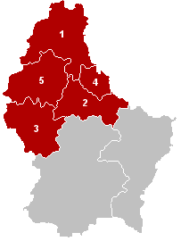
English: This image was copied from nl.wikipedia.org. The original description was: Districtkaart, eigen werk
Nummering
edit
| This work has been released into the public domain by its author, LennartBolks. This applies worldwide. In some countries this may not be legally possible; if so: |
nl:Afbeelding:District DiekirchLocatie.png
File history
Click on a date/time to view the file as it appeared at that time.
| Date/Time | Thumbnail | Dimensions | User | Comment | |
|---|---|---|---|---|---|
| current | 17:24, 27 October 2011 | | 203 × 270 (4 KB) | Les Meloures (talk | contribs) | New version after changes in composition of muninipalities |
| 13:26, 1 August 2006 |  | 203 × 270 (4 KB) | Bastin8 (talk | contribs) | ||
| 17:59, 8 May 2006 |  | 203 × 270 (4 KB) | Markussep (talk | contribs) | Bastendorf + Fouhren --> Tandel | |
| 18:27, 22 December 2004 |  | 203 × 270 (3 KB) | LennartBolks~commonswiki (talk | contribs) | This image was copied from nl.wikipedia.org. The original description was: Districtkaart, eigen werk ==Nummering== #Clervaux #Diekirch #Redange #Vianden #[[Kanton Wiltz|Wiltz] |
You cannot overwrite this file.
File usage on Commons
The following 3 pages use this file:
File usage on other wikis
The following other wikis use this file:
- Usage on als.wikipedia.org
- Usage on be.wikipedia.org
- Usage on bg.wikipedia.org
- Usage on ca.wikipedia.org
- Usage on da.wikipedia.org
- Usage on de.wikipedia.org
- Usage on en.wikipedia.org
- Usage on en.wikivoyage.org
- Usage on eo.wikipedia.org
- Usage on es.wikipedia.org
- Usage on eu.wikipedia.org
- Usage on id.wikipedia.org
- Usage on it.wikipedia.org
- Usage on ja.wikipedia.org
- Usage on kk.wikipedia.org
- Usage on ko.wikipedia.org
- Usage on lb.wikipedia.org
- Usage on li.wikipedia.org
- Usage on lt.wikipedia.org
- Usage on nl.wikipedia.org
- Usage on nn.wikipedia.org
- Usage on no.wikipedia.org
- Usage on pl.wikipedia.org
- Usage on pnb.wikipedia.org
- Usage on pt.wikipedia.org
- Usage on ro.wikipedia.org
- Usage on ru.wikipedia.org
- Usage on sco.wikipedia.org
- Usage on simple.wikipedia.org
- Usage on sk.wikipedia.org
- Usage on sv.wikipedia.org
- Usage on tr.wikipedia.org
- Usage on uk.wikipedia.org
- Usage on www.wikidata.org
- Usage on zh-min-nan.wikipedia.org
- Usage on zh.wikipedia.org