File:Dorogomilovsky Val Street overlaid on present-day map.png

Size of this preview: 628 × 599 pixels. Other resolutions: 252 × 240 pixels | 503 × 480 pixels | 740 × 706 pixels.
Original file (740 × 706 pixels, file size: 597 KB, MIME type: image/png)
Captions
Captions
Add a one-line explanation of what this file represents
Summary
edit
| Description |
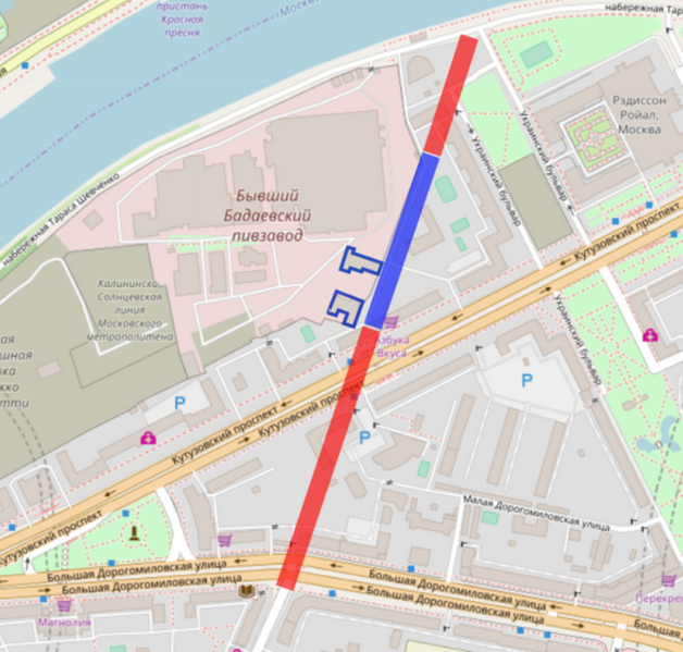
OpenStreetMap cut-out (or derivative work based on it): Русский: Трасса несуществующей ныне улицы Дорогомиловский Вал. Красным = утраченные фрагменты, синим = сохранившийся внутриквартальный проезд.
English: Route of former Dorogomilovsky Val Street (Moscow) overlaid on present-day map This cut-out may be incomplete, and may contain errors, or may be obsolete. Don't rely solely on it for navigation. Seek for the present state in original context on the OpenStreetMap wiki page |
| Date | |
| Source | OpenStreetMap project data |
| Author | OpenStreetMap contributors |
| Permission (Reusing this file) |
All OpenStreetMap data and maps are licensed under: This file is licensed under the Creative Commons Attribution-Share Alike 2.0 Generic license.
|
OpenStreetMap maps of Moscow
File history
Click on a date/time to view the file as it appeared at that time.
| Date/Time | Thumbnail | Dimensions | User | Comment | |
|---|---|---|---|---|---|
| current | 22:02, 22 February 2018 | | 740 × 706 (597 KB) | Retired electrician (talk | contribs) | |
| 21:56, 22 February 2018 |  | 853 × 751 (664 KB) | Retired electrician (talk | contribs) | {{OpenStreetMapImage |description = {{ru|1= Трасса несуществующей ныне улицы Дорогомиловский Вал. Красным = утраченные фрагменты, синим = сохранившийся внутриквартальный проезд.}} {{en|1= Route of former Dorogomilovsky Val Street (Moscow) overlaid on present-day map }} |date = 2018-02-22 |name = Dorogomilovo |cat = OpenStreetMap maps of Moscow }} Category:Dorogomilovo Category:Kamer-Kollezhsky Val |
You cannot overwrite this file.
File usage on Commons
The following 2 pages use this file:
File usage on other wikis
The following other wikis use this file:
- Usage on ru.wikipedia.org