File:East Prussia 1923-1939 map-fr.svg

Size of this PNG preview of this SVG file: 651 × 600 pixels. Other resolutions: 261 × 240 pixels | 521 × 480 pixels | 834 × 768 pixels | 1,111 × 1,024 pixels | 2,223 × 2,048 pixels | 865 × 797 pixels.
Original file (SVG file, nominally 865 × 797 pixels, file size: 234 KB)
Captions
Captions
Add a one-line explanation of what this file represents
Summary
edit| Description |
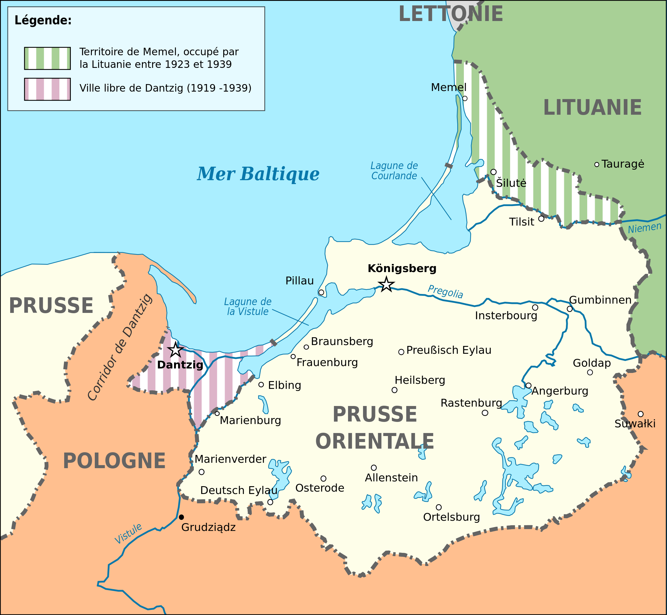
Deutsch: Karte von Ostpreußen 1923-1939. English: Map of Germany's province of East Prussia from 1923 to 1939, with Memelland occupied by Lithuania since 1923. Français : Carte de la province allemande de Prusse-Orientale entre 1923 et 1939, montrant la zone de Memel occupée par la Lituanie depuis 1923. Magyar: Kelet-Poroszország térképe 1923-1939 között. |
||||
| Date | (UTC) | ||||
| Source |
This file was derived from: East Prussia 1939.JPG:  |
||||
| Author |
|
||||
| Other versions |
[]
| ||||
| SVG | W3C-validity not checked.
|
||||
| Graphic Lab |


| Object location | | View this and other nearby images on: OpenStreetMap |
|---|
Licensing
edit
I, the copyright holder of this work, hereby publish it under the following license:
This file is licensed under the Creative Commons Attribution-Share Alike 3.0 Unported license.
- You are free:
- to share – to copy, distribute and transmit the work
- to remix – to adapt the work
- Under the following conditions:
- attribution – You must give appropriate credit, provide a link to the license, and indicate if changes were made. You may do so in any reasonable manner, but not in any way that suggests the licensor endorses you or your use.
- share alike – If you remix, transform, or build upon the material, you must distribute your contributions under the same or compatible license as the original.
Original upload log
edit
This image is a derivative work of the following images:
- File:East_Prussia_1939.JPG licensed with Cc-by-sa-3.0-migrated, GFDL
- 2008-03-24T22:23:30Z Renata3 752x808 (95143 Bytes) did not crop properly
- 2008-03-24T20:41:51Z Renata3 824x818 (96055 Bytes) cropped white space
- 2006-12-22T22:30:28Z Electionworld 824x818 (303157 Bytes) {{ew|en|Schwartz und Weiss}} East Prussia 1939 {{GFDL}} [[Category:Maps of East Prussia]] [[Category:Maps of the history of Poland]] [[Category:Maps of the history of Russia]] [[Category:Maps of the history of Germany]] [[Cat
Uploaded with derivativeFX
File history
Click on a date/time to view the file as it appeared at that time.
| Date/Time | Thumbnail | Dimensions | User | Comment | |
|---|---|---|---|---|---|
| current | 02:03, 3 May 2024 | | 865 × 797 (234 KB) | BlackShadowG (talk | contribs) | File uploaded using svgtranslate tool (https://svgtranslate.toolforge.org/). Added translation for zh-hans. |
| 20:09, 13 October 2022 |  | 865 × 797 (202 KB) | Ispanas (talk | contribs) | File uploaded using svgtranslate tool (https://svgtranslate.toolforge.org/). Added translation for lt. | |
| 13:53, 13 June 2020 |  | 865 × 797 (170 KB) | Nk (talk | contribs) | File uploaded using svgtranslate tool (https://svgtranslate.toolforge.org/). Added translation for bg. | |
| 09:53, 17 April 2020 |  | 865 × 797 (127 KB) | Flappiefh (talk | contribs) | Baltiisk was named Pillau before 1946. | |
| 13:12, 26 May 2014 |  | 865 × 797 (127 KB) | Sémhur (talk | contribs) | Valid SVG | |
| 14:40, 4 September 2012 |  | 865 × 797 (127 KB) | Sémhur (talk | contribs) | == {{int:filedesc}} == {{Information |Description={{Multilingual description |en= Map of Germany's province of en:East Prussia from 1923 to 1939, with Memelland occupied by Lithuania since 1923 |fr= Carte de la province allemande de [[:fr:Prusse-... |
You cannot overwrite this file.
File usage on Commons
The following 12 pages use this file:
- File:East Prussia 1923-1939.png
- File:East Prussia 1923-1939.svg
- File:East Prussia 1923-1939 map-el.svg
- File:East Prussia 1923-1939 map-es.svg
- File:East Prussia 1923-1939 map-fr.svg
- File:East Prussia 1923-1939 map-nl.svg
- File:East Prussia 1923-1939 map-zh-hans.svg
- File:East Prussia 1923-1939 map hu.svg
- File:East Prussia 1939.JPG
- File:Ostpreußen hu 1923-1939.jpg
- Template:Other versions/East Prussia 1923-1939
- Category:1920 stamps of Marienwerder
File usage on other wikis
The following other wikis use this file:
- Usage on bg.wikipedia.org
- Usage on fr.wikipedia.org
- Usage on ko.wikipedia.org
- Usage on lt.wikipedia.org
- Usage on www.wikidata.org