File:Edstone Aqueduct in Warwickshire, geograph 4723831 by Mat Fascione.jpg
Size of this preview: 683 × 599 pixels. Other resolutions: 274 × 240 pixels | 547 × 480 pixels.
Original file (800 × 702 pixels, file size: 173 KB, MIME type: image/jpeg)
Captions
Captions
Add a one-line explanation of what this file represents
Summary
edit| Description |
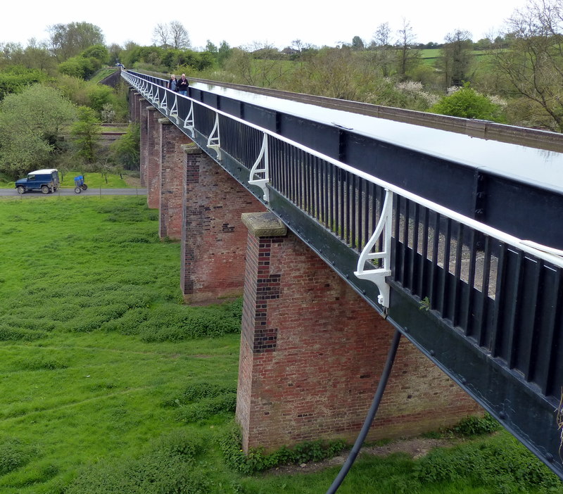
English: This 475 feet (145 m) aqueduct is the longest in England, it opened in 1816 and is a Grade II listed structure. It carries the Stratford-upon-Avon Canal across a road, a stream and the Birmingham and North Warwickshire railway. |
||
| Date | |||
| Source | geograph.org.uk | ||
| Author | Mat Fascione | ||
| Permission (Reusing this file) |
This file is licensed under the Creative Commons Attribution-Share Alike 2.0 Generic license. Attribution: Mat Fascione
|
||
| Attribution (required by the license) | Mat Fascione / Edstone Aqueduct in Warwickshire / | ||

| Camera location | | View this and other nearby images on: OpenStreetMap |
|---|
_region:GB-ENG_heading:180.00&language=en)
| Object location | | View this and other nearby images on: OpenStreetMap |
|---|
_region:GB-ENG_heading:180.00&language=en)
File history
Click on a date/time to view the file as it appeared at that time.
| Date/Time | Thumbnail | Dimensions | User | Comment | |
|---|---|---|---|---|---|
| current | 01:26, 29 April 2022 | | 800 × 702 (173 KB) | G-13114 (talk | contribs) | {{Information |description={{en|1=This 475 feet (145 m) aqueduct is the longest in England, it opened in 1816 and is a Grade II listed structure. It carries the Stratford-upon-Avon Canal across a road, a stream and the Birmingham and North Warwickshire railway.}} |date=2015-05-04 |source= [https://www.geograph.org.uk geograph.org.uk] |author= Mat Fascione |permission= {{Geograph|4723831|Mat Fascione}} |other_versions= |other fields= {{Credit line |Author = Mat Fascione |Other = ''Eds... |
You cannot overwrite this file.
File usage on Commons
There are no pages that use this file.
File usage on other wikis
The following other wikis use this file:
- Usage on en.wikipedia.org