File:Elijah Saphir, מפת ארץ ישראל (פלשתינה) (FL199992287 2369250).tif

Size of this JPG preview of this TIF file: 403 × 599 pixels. Other resolutions: 161 × 240 pixels | 323 × 480 pixels | 517 × 768 pixels | 689 × 1,024 pixels | 1,379 × 2,048 pixels | 13,304 × 19,761 pixels.
Original file (13,304 × 19,761 pixels, file size: 752.24 MB, MIME type: image/tiff)
Captions
Captions
Add a one-line explanation of what this file represents
Summary
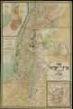
edit| Map of Palestine
|
|||||||||||||||||||||||||||||||||||||||||||||||||||||||||
|---|---|---|---|---|---|---|---|---|---|---|---|---|---|---|---|---|---|---|---|---|---|---|---|---|---|---|---|---|---|---|---|---|---|---|---|---|---|---|---|---|---|---|---|---|---|---|---|---|---|---|---|---|---|---|---|---|---|
| Artist |
|
_(FL199992287_2369250).jpg) | |||||||||||||||||||||||||||||||||||||||||||||||||||||||
| Title |
Hebrew: מפת ארץ ישראל Map of Palestine |
||||||||||||||||||||||||||||||||||||||||||||||||||||||||
| Publisher | |||||||||||||||||||||||||||||||||||||||||||||||||||||||||
| Object type |
topographic map |
||||||||||||||||||||||||||||||||||||||||||||||||||||||||
| Genre |
map |
||||||||||||||||||||||||||||||||||||||||||||||||||||||||
| Description |
מפת ארץ ישראל (פלשתינה). עפי מפת קיפרט ערוכה עי א. ספיר והמהנדס א. קרוזה.. |
||||||||||||||||||||||||||||||||||||||||||||||||||||||||
| Language |
Hebrew |
||||||||||||||||||||||||||||||||||||||||||||||||||||||||
| Publication date |
between 1912 and 1913 |
||||||||||||||||||||||||||||||||||||||||||||||||||||||||
| Dimensions |
height: 1,920 mm (75.5 in) |
||||||||||||||||||||||||||||||||||||||||||||||||||||||||
| Collection |
|
||||||||||||||||||||||||||||||||||||||||||||||||||||||||
| Current location |
|
||||||||||||||||||||||||||||||||||||||||||||||||||||||||
| Place of publication |
Berlin |
||||||||||||||||||||||||||||||||||||||||||||||||||||||||
| Notes |
Gezeichnet v. Paul Krause & Sandor Kästner; Lithographie & Druck v. Dietrich Reimer (E.Vohsen) | ||||||||||||||||||||||||||||||||||||||||||||||||||||||||
| IE PID | IE199992285 | ||||||||||||||||||||||||||||||||||||||||||||||||||||||||
| Rosetta filename | FL199992287 | ||||||||||||||||||||||||||||||||||||||||||||||||||||||||
| NNL item ID (P3959) | 990023692500205171 | ||||||||||||||||||||||||||||||||||||||||||||||||||||||||
| search Merhav catalog | Hebrew, Elijah Saphir, Berlin | ||||||||||||||||||||||||||||||||||||||||||||||||||||||||
| search Merhav catalog | Twelve tribes of IsraelMapsהוצאת הועד הפועל הציוני (ברלין) | ||||||||||||||||||||||||||||||||||||||||||||||||||||||||
| Source/Photographer |
|
||||||||||||||||||||||||||||||||||||||||||||||||||||||||
| Other versions | |||||||||||||||||||||||||||||||||||||||||||||||||||||||||
| Jpg / Tif version |
|
||||||||||||||||||||||||||||||||||||||||||||||||||||||||

Loescher_%26_btv1b8453164n_(cropped).jpg)


Licensing
editThe copyright situation of this work is theoretically uncertain, because in the country of origin copyright lasts 70 years after the death of the author, and the date of the author's death is unknown. However, the date of creation of the work was over 120 years ago, and it is thus a reasonable assumption that the copyright has expired (see here for the community discussion). Do not use this template if the date of death of the author is known.
| |
| This file has been identified as being free of known restrictions under copyright law, including all related and neighboring rights. | |
File history
Click on a date/time to view the file as it appeared at that time.
| Date/Time | Thumbnail | Dimensions | User | Comment | |
|---|---|---|---|---|---|
| current | 23:06, 27 July 2023 |  | 13,304 × 19,761 (752.24 MB) | Geagea (talk | contribs) | c:User:Rillke/bigChunkedUpload.js: =={{int:filedesc}}== {{Artwork |artist = |author = |title = |description = מפת ארץ ישראל (פלשתינה). עפי מפת קיפרט ערוכה עי א. ספיר והמהנדס א. קרוזה.. |language = |date = |publication date = |medium = |dimensions = |institution = |department = {{Institution:National Library of Israel}} |place of publication = |object history = |exhibition history = |credit line = |inscriptions = |publisher = |notes = Gezeichnet v. Paul Kr... |
You cannot overwrite this file.
File usage on Commons
The following 7 pages use this file:
- File:Elijah Saphir, מפת ארץ ישראל (פלשתינה) (FL199992287 2369250).jpg
- File:Elijah Saphir, מפת ארץ ישראל (פלשתינה) (FL199992287 2369250).tif
- File:Elijah Saphir, מפת ארץ ישראל (פלשתינה) (FL199992287 2369250) (cropped).jpg
- File:ים כנרת. Elijah Saphir, מפת ארץ ישראל (פלשתינה) (FL199992287 2369250) (cropped).jpg
- File:ירוּשׁלם בימי החורבן השניElijah Saphir, מפת ארץ ישראל (פלשתינה) (FL199992287 2369250) (cropped).jpg
- File:קנה המדה. Elijah Saphir, מפת ארץ ישראל (פלשתינה) (FL199992287 2369250) (cropped).jpg
- File:שבטי ישראל. Elijah Saphir, מפת ארץ ישראל (פלשתינה) (FL199992287 2369250) (cropped).jpg
_(FL199992287_2369250)_(cropped).jpg)
_(FL199992287_2369250)_(cropped).jpg)
_(FL199992287_2369250)_(cropped).jpg)
_(FL199992287_2369250)_(cropped).jpg)
_(FL199992287_2369250)_(cropped).jpg)