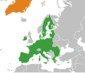
File:European Union Greenland Locator.svg

Size of this PNG preview of this SVG file: 800 × 406 pixels. Other resolutions: 320 × 162 pixels | 640 × 325 pixels | 1,024 × 520 pixels | 1,280 × 650 pixels | 2,560 × 1,300 pixels | 2,754 × 1,398 pixels.
Original file (SVG file, nominally 2,754 × 1,398 pixels, file size: 1.05 MB)
File information
Structured data
Captions
Captions
Add a one-line explanation of what this file represents
| DescriptionEuropean Union Greenland Locator.svg | European Union - Greenland locator map | |||
| Date | ||||
| Source | Own work | |||
| Author | Own work | |||
| Permission (Reusing this file) |
|
File history
Click on a date/time to view the file as it appeared at that time.
| Date/Time | Thumbnail | Dimensions | User | Comment | |
|---|---|---|---|---|---|
| current | 10:21, 24 January 2022 |  | 2,754 × 1,398 (1.05 MB) | Saftorangen (talk | contribs) | use BlankMap-World.svg as template to show all affected areas |
| 09:38, 27 March 2020 |  | 1,981 × 1,701 (641 KB) | Hogweard (talk | contribs) | Update | |
| 18:21, 29 July 2014 |  | 2,047 × 1,720 (830 KB) | Masterdeis (talk | contribs) | +Croatia | |
| 14:17, 2 September 2010 |  | 2,047 × 1,720 (870 KB) | Alvaro1984 18 (talk | contribs) | {{Information |Description={{en|1=The European Union and Greenland}} |Source=*File:European_Union_Israel_Locator.svg |Date=2010-09-02 14:15 (UTC) |Author=*File:European_Union_Israel_Locator.svg: Ssolbergj *derivative work: ~ | |
| 23:12, 14 May 2010 |  | 940 × 415 (1.54 MB) | CGN2010 (talk | contribs) | {{Information |Description=European Union - Greenland locator map |Source={{own}} |Date=2010-05-15 |Author={{own}} |Permission={{PD-self}} |other_versions= }} Category:Bilateral maps of the European Union Category:maps of Greenland |
You cannot overwrite this file.
File usage on Commons
There are no pages that use this file.
File usage on other wikis
The following other wikis use this file:
- Usage on da.wikipedia.org
- Usage on en.wikipedia.org
- Usage on es.wikipedia.org
- Usage on et.wikipedia.org
- Usage on fr.wikipedia.org
- Usage on nl.wikipedia.org
- Usage on ru.wikipedia.org
- Usage on uk.wikipedia.org
- Usage on www.wikidata.org
- Usage on zh.wikipedia.org
Metadata
This file contains additional information such as Exif metadata which may have been added by the digital camera, scanner, or software program used to create or digitize it. If the file has been modified from its original state, some details such as the timestamp may not fully reflect those of the original file. The timestamp is only as accurate as the clock in the camera, and it may be completely wrong.
| Short title | World Map |
|---|---|
| Width | 2754 |
| Height | 1398 |