File:Füssen - Blick über den Allgäu vom Tegelberg (3179-81).jpg

Original file (3,000 × 2,000 pixels, file size: 2.31 MB, MIME type: image/jpeg)
Captions
Captions
Summary
edit| Description |
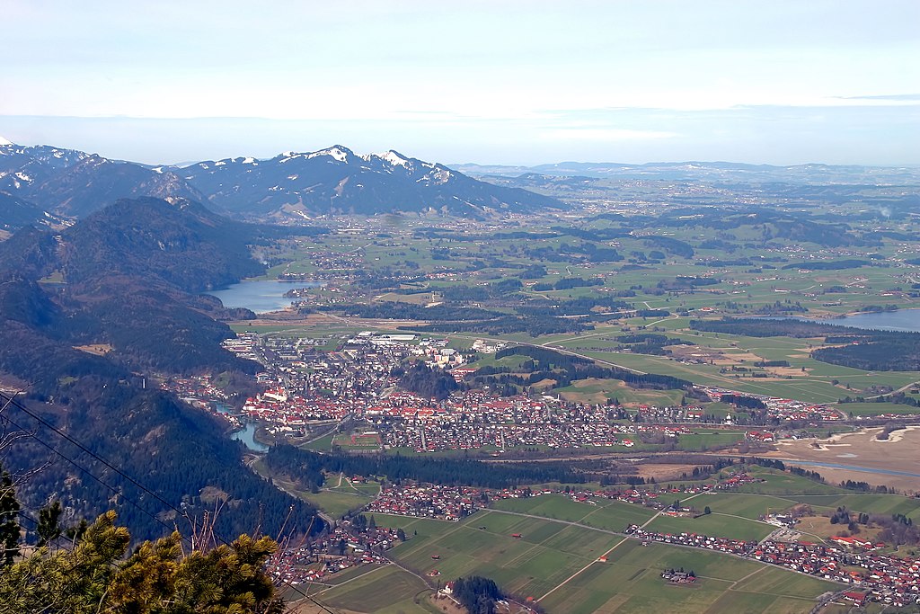
Deutsch: Blick auf Füssen und Umgebung vom Tegelberg: Falkensteinkamm mit Salober und den anderen überwiegend bewaldeten Gipfeln von Bad Faulenbach am Lech in Richtung Pfronten (nach Westen). In den Hügeln nahe Füssen andeutungsweise der Obersee bzw. der hellbeige Uferbereich, weiter entfernt der kleine Alatsee etwa auf Höhe des weit ausgedehnteren Weißensees am Rand vom Voralpenland (im Foto rechts des Falkensteinkamms). Einige niedrigere Berge der Allgäuer Alpen mit Schnee auf den Hängen - Edelsberg und Alpspitz. |
|||||||||||||||||
| Date | ||||||||||||||||||
| Source | Own work | |||||||||||||||||
| Author |
|
|||||||||||||||||
| Attribution (required by the license) | © Raimond Spekking / | |||||||||||||||||

.jpg&action=edit§ion=1)
| Camera location | | View this and other nearby images on: OpenStreetMap |
|---|
.jpg¶ms=047.559731_N_0010.779428_E_globe:Earth_type:camera_alt:1695_source:exif_heading:281.43&language=en)
Licensing
edit.jpg&action=edit§ion=2)
I have published this image as author under the Creative-Commons-Licence CC BY-SA 4.0.. This means that free online usage outside of Wikimedia projects under the following terms of licence is possible:
- The image is credited with "© Raimond Spekking / CC BY-SA 4.0 (via Wikimedia Commons)"
For all other kind of usages (books, journales, flyers, etc.) click on the following button. You will get all information needed.
.jpg)
I would be happy to receive a specimen copy or the URL of the website where the image is used.
Please write an email to raimond.spekking@gmail.com (GPG encrypted emails are welcome: Key-ID: 0xB12BE7A6), if you
- need the image in a higher resolution
- need my postal address for sending a specimen copy
- have further questions to the terms of licence
- You are free:
- to share – to copy, distribute and transmit the work
- to remix – to adapt the work
- Under the following conditions:
- attribution – You must give appropriate credit, provide a link to the license, and indicate if changes were made. You may do so in any reasonable manner, but not in any way that suggests the licensor endorses you or your use.
- share alike – If you remix, transform, or build upon the material, you must distribute your contributions under the same or compatible license as the original.
| Annotations | This image is annotated: View the annotations at Commons |
.jpg)
File history
Click on a date/time to view the file as it appeared at that time.
| Date/Time | Thumbnail | Dimensions | User | Comment | |
|---|---|---|---|---|---|
| current | 19:50, 9 November 2010 | | 3,000 × 2,000 (2.31 MB) | Raymond (talk | contribs) | == {{int:filedesc}} == {{Information |Description={{de|Blick auf Füssen und Umgebung vom Tegelberg.}} |Source={{own}} |Date=2010-04-03 |Author=Raymond - Raimond Spekking |Permission= |other_versions= |other_fields={{User:Raymond/attribut |
You cannot overwrite this file.
File usage on Commons
The following 2 pages use this file:
.jpg&oldid=837972354)