File:FAW-points2.jpg

Size of this preview: 800 × 600 pixels. Other resolutions: 320 × 240 pixels | 640 × 480 pixels | 1,024 × 768 pixels | 1,280 × 960 pixels | 1,600 × 1,200 pixels.
Original file (1,600 × 1,200 pixels, file size: 814 KB, MIME type: image/jpeg)
Captions
Captions
Add a one-line explanation of what this file represents
| Description |
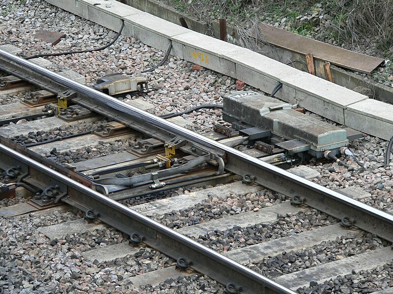
English: A closeup of the converging points immediately north of w:Filton Abbey Wood railway station. In this configuration the track is set for trains from w:South Wales or Avonmouth via Brentry.
Русский: Железнодорожная стрелка к северу от станции Филтон Эбби Вуд крупным планом. В данном положении маршрут задан для поездов из Уэльса или Эвонмауфа через Брентри. |
|
| Date | ||
| Source | Own work | |
| Author | Chris McKenna | |
| Permission (Reusing this file) |
Chris McKenna (en:User:Thryduulf), the copyright holder of this work, hereby publishes it under the following licenses: This file is licensed under the Creative Commons Attribution-Share Alike 4.0 International license. Attribution: Chris McKenna (Thryduulf)
This file is licensed under the Creative Commons Attribution-Share Alike 3.0 Unported, 2.5 Generic, 2.0 Generic and 1.0 Generic license. Attribution: Chris McKenna (Thryduulf)
You may select the license of your choice.
|
| Camera location | | View this and other nearby images on: OpenStreetMap |
|---|
File history
Click on a date/time to view the file as it appeared at that time.
| Date/Time | Thumbnail | Dimensions | User | Comment | |
|---|---|---|---|---|---|
| current | 15:37, 17 March 2006 | | 1,600 × 1,200 (814 KB) | Thryduulf (talk | contribs) | A closeup of the converging points immediately north of w:Filton Abbey Wood railway station. In this configuration the track is set for trains from w:South Wales or w:Avonmouth via w:Brentry {{user:Thryduulf/cc-by-sa-all}} [[category:Fi |
You cannot overwrite this file.
File usage on Commons
There are no pages that use this file.