File:Fazendeville Louisiana Map 1951.jpg

Size of this preview: 551 × 600 pixels. Other resolutions: 220 × 240 pixels | 441 × 480 pixels | 705 × 768 pixels | 940 × 1,024 pixels | 1,881 × 2,048 pixels | 4,275 × 4,655 pixels.
Original file (4,275 × 4,655 pixels, file size: 6.67 MB, MIME type: image/jpeg)
Captions
Captions
Add a one-line explanation of what this file represents
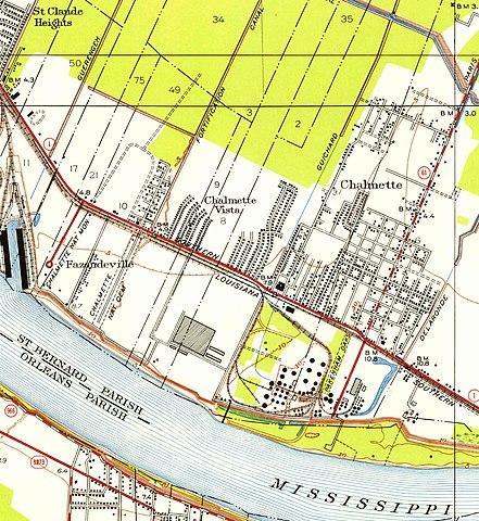
| Description | Portion of 1951 United States Geological Survey map of Chalmette area, showing the since destroyed town of Fazendeville and its relationship to the Battle of New Orleans site and town of Chalmette. | |||
| Date | map date; published 1953 | |||
| Source | Via USGS website [1]; converted from PDF to jpg, cropped to show Fazendeville area, before uploading to Wikimedia Commons | |||
| Author | US Geological Survey | |||
| Permission (Reusing this file) |
|
|||
| Other versions | Full map: File:LA Chalmette 331651 1951 24000 geo.jpg |
File history
Click on a date/time to view the file as it appeared at that time.
| Date/Time | Thumbnail | Dimensions | User | Comment | |
|---|---|---|---|---|---|
| current | 13:41, 19 April 2012 | | 4,275 × 4,655 (6.67 MB) | Infrogmation (talk | contribs) | {{Information |Description= Portion of 1951 United States Geological Survey map of Chalmette area, showing the since destroyed town of Fazendeville and its relationship to the Battle of New Orleans site and town of Chalmette. |Source= Via USGS website ... |
You cannot overwrite this file.
File usage on Commons
There are no pages that use this file.
File usage on other wikis
The following other wikis use this file:
- Usage on en.wikipedia.org