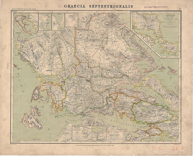
File:Formae Orbis Antiqui - XV Graecia septentrionalis (UoCL G6812-C4S2-1894-K5).jpg

Size of this preview: 741 × 600 pixels. Other resolutions: 297 × 240 pixels | 593 × 480 pixels | 949 × 768 pixels | 1,265 × 1,024 pixels | 2,530 × 2,048 pixels | 9,804 × 7,938 pixels.
Original file (9,804 × 7,938 pixels, file size: 26.04 MB, MIME type: image/jpeg)
File information
Structured data
Captions
Captions
Add a one-line explanation of what this file represents
Summary edit
| Title |
Graecia septentrionalis |
|||||||||||||||||||||||
| DescriptionFormae Orbis Antiqui - XV Graecia septentrionalis (UoCL G6812-C4S2-1894-K5).jpg |
English: Ancient central Greece and Euboea |
|||||||||||||||||||||||
| Date | ||||||||||||||||||||||||
| Source | University of Chicago Digital Preservation Collection | |||||||||||||||||||||||
| Creator |
creator QS:P170,Q65958
lithographer: J. & R. Sulzer |
|||||||||||||||||||||||
| Permission (Reusing this file) |
|
|||||||||||||||||||||||
| Geotemporal data | ||||||||||||||||||||||||
| Map location | Central Greece and Euboea | |||||||||||||||||||||||
| Map type | Topographic map | |||||||||||||||||||||||
| Scale | 1:600,000 | |||||||||||||||||||||||
| Heading |
|
|||||||||||||||||||||||
| Bounding box |
|
|||||||||||||||||||||||
| Georeferencing | Georeference the map in Wikimaps Warper If inappropriate please set warp_status = skip to hide. | |||||||||||||||||||||||
| Bibliographic data | ||||||||||||||||||||||||
| Part of the series | Formae Orbis Antiqui | |||||||||||||||||||||||
| Map sheet | XV | |||||||||||||||||||||||
| Language | Latin | |||||||||||||||||||||||
| Publisher |
Dietrich Reimer (Hoefer & Vohsen) |
|||||||||||||||||||||||
| Printed by |
L. Kraatz |
|||||||||||||||||||||||
| Archival data | ||||||||||||||||||||||||
| Collection |
institution QS:P195,Q7895259 |
|||||||||||||||||||||||
| Accession number |
G6812.C4S2 1894 .K5 |
|||||||||||||||||||||||
| Dimensions |
height: 43 cm (16.9 in); width: 55 cm (21.6 in) dimensions QS:P2048,43U174728 dimensions QS:P2049,55U174728 [height: 51 cm (20 in); width: 63 cm (24.8 in)dimensions QS:P2048,51U174728 dimensions QS:P2049,63U174728 ] |
|||||||||||||||||||||||
| Notes |
English: Includes inset continuation map and inset maps:
Latina: Euboeae pars orientalis 1:600000 – Cocyra insula 1:800000 – Corcyra urbs 1:100000 – Leucas urbs 1:100000 – Dodona urbs 1:25000 – Malidis (ionice Melidis) ora circa Thermopylas tempore belli Persici 1:300000 |
|||||||||||||||||||||||
File history
Click on a date/time to view the file as it appeared at that time.
| Date/Time | Thumbnail | Dimensions | User | Comment | |
|---|---|---|---|---|---|
| current | 19:37, 4 May 2017 |  | 9,804 × 7,938 (26.04 MB) | WaldiWuff (talk | contribs) | == {{int:filedesc}} == {{Map |title = Graecia septentrionalis |description = {{en|Ancient central Greece and Euboea}} |legend = |author = {{Creator:Heinrich Kiepert}} {{Occupation|lithographer}}: J. & R. Sulzer... |
You cannot overwrite this file.
File usage on Commons
The following page uses this file:


