File:France, administrative divisions - de (+overseas) - colored 2016.svg

Size of this PNG preview of this SVG file: 624 × 600 pixels. Other resolutions: 250 × 240 pixels | 499 × 480 pixels | 799 × 768 pixels | 1,066 × 1,024 pixels | 2,131 × 2,048 pixels | 2,000 × 1,922 pixels.
Original file (SVG file, nominally 2,000 × 1,922 pixels, file size: 1.81 MB)
Captions
Captions
Add a one-line explanation of what this file represents
Summary edit
_-_colored_2016.svg&action=edit§ion=1)
| Description |
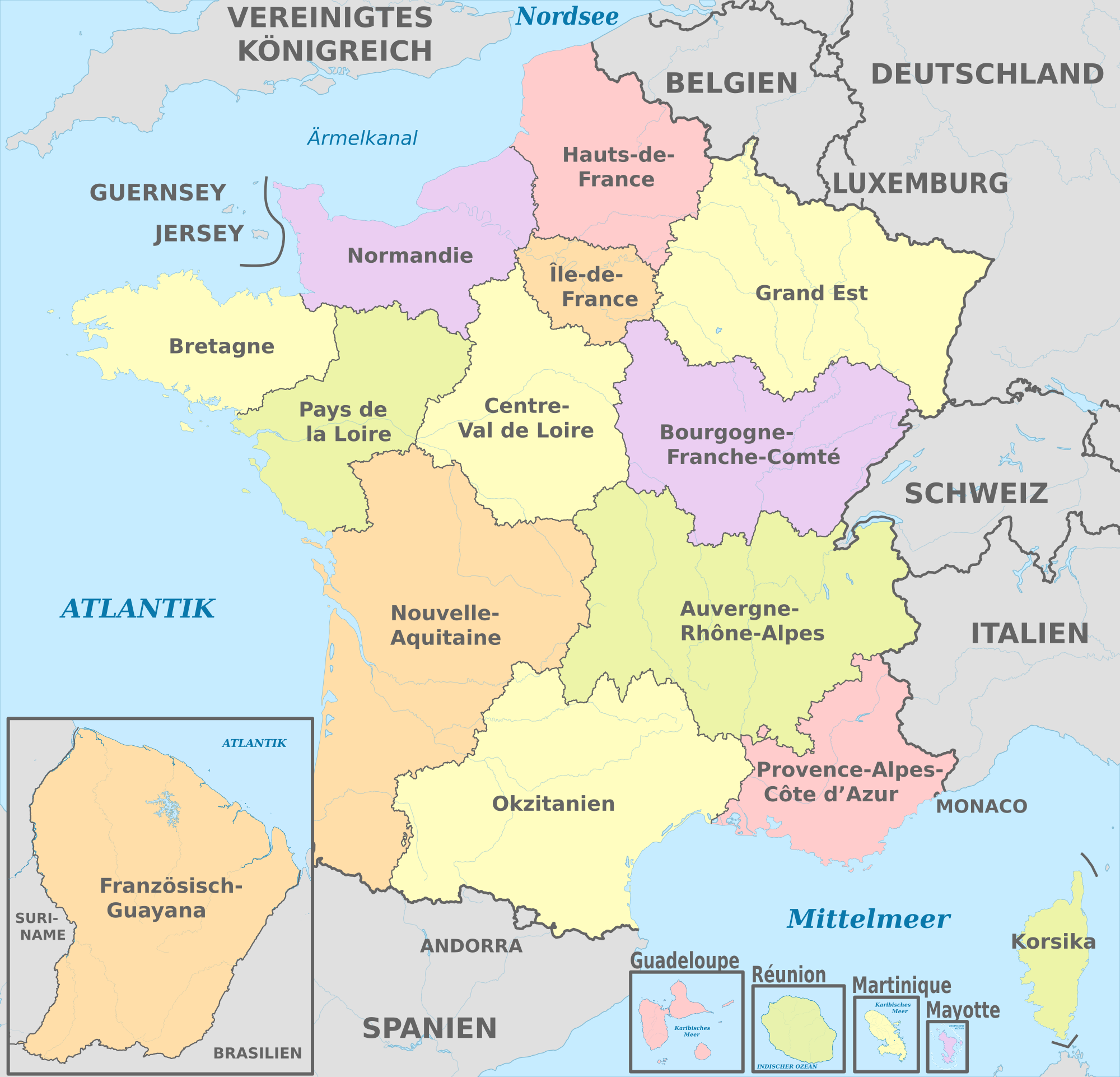
Deutsch: Karte der politischen Gliederung von Frankreich ab 1. Januar 2016 (Arbeitsnamen)
English: Map of administrative divisions of France since 1st Jan 2016 (working titles) |
||
| Date | |||
| Source |
Own work This W3C-unspecified vector image was created with Adobe Illustrator. This vector image includes elements that have been taken or adapted from this file: This vector image includes elements that have been taken or adapted from this file: |
||
| Author |
TUBS |
||
| Other versions |
|
_-_colored.svg)
Licensing edit
_-_colored_2016.svg&action=edit§ion=2)
I, the copyright holder of this work, hereby publish it under the following license:
This file is licensed under the Creative Commons Attribution-Share Alike 3.0 Germany license.
- You are free:
- to share – to copy, distribute and transmit the work
- to remix – to adapt the work
- Under the following conditions:
- attribution – You must give appropriate credit, provide a link to the license, and indicate if changes were made. You may do so in any reasonable manner, but not in any way that suggests the licensor endorses you or your use.
- share alike – If you remix, transform, or build upon the material, you must distribute your contributions under the same or compatible license as the original.


|
I'd greatly appreciate, that you attribute this media file to Wikimedia Commons, if used outside Wikipedia or Commons. For use in publications such as books, newspapers, blogs, websites, please insert here the following line:
|
_-_colored_2016.svg)
File history
Click on a date/time to view the file as it appeared at that time.
| Date/Time | Thumbnail | Dimensions | User | Comment | |
|---|---|---|---|---|---|
| current | 20:13, 9 December 2016 | | 2,000 × 1,922 (1.81 MB) | Chumwa (talk | contribs) | neue Regionsnamen sind festgelegt |
| 14:15, 28 December 2015 |  | 2,000 × 1,922 (1.84 MB) | TUBS (talk | contribs) | == {{int:filedesc}} == {{Information |Description={{de|Karte der politischen Gliederung von Frankreich ab 1. Januar 2016 (Arbeitsnamen)}} {{en|Map of administrative divisions of France since 1st Jan 2016 (working titles)}} |Source={{own}}{{Adobe Illus... |
You cannot overwrite this file.
File usage on Commons
The following 11 pages use this file:
- User:Arnaud Palastowicz/Film cats
- User:Chumwa/Gallery
- File:France, administrative divisions - de (+overseas) - colored 2016, Noto font.svg
- File:France, administrative divisions - en (+overseas) - colored 2016.svg
- File:France, administrative divisions - es (+overseas) - colored 2016.svg
- File:France, administrative divisions - fr (+overseas) - colored 2016.svg
- File:France, administrative divisions - ja (+overseas) - colored 2016.svg
- File:France, administrative divisions - th (+overseas) - colored 2016.svg
- File:France, administrative divisions - zh-hans (+overseas) - colored 2016.svg
- File:France, administrative divisions - zh-hant (+overseas) - colored 2016.svg
- File:Regioni amministrative francesi.svg
_-_colored_2016,_Noto_font.svg)
_-_colored_2016.svg)
_-_colored_2016.svg)
_-_colored_2016.svg)
_-_colored_2016.svg)
_-_colored_2016.svg)
_-_colored_2016.svg)
_-_colored_2016.svg)
File usage on other wikis
The following other wikis use this file:
- Usage on als.wikipedia.org
- Usage on de.wikipedia.org
- Usage on es.wikipedia.org
- Usage on frr.wikipedia.org
- Usage on it.wikipedia.org
- Usage on lv.wikipedia.org
- Usage on sl.wikipedia.org
- Usage on to.wikipedia.org
_-_colored_2016.svg&oldid=501394448)