File:Gask Ridge Limes 85 n. chr.png

Size of this preview: 800 × 595 pixels. Other resolutions: 320 × 238 pixels | 640 × 476 pixels | 1,024 × 761 pixels | 1,280 × 952 pixels | 1,434 × 1,066 pixels.
Original file (1,434 × 1,066 pixels, file size: 692 KB, MIME type: image/png)
Captions
Captions
Add a one-line explanation of what this file represents
Summary edit
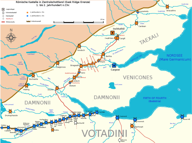
| Description | Römische Kastelle in Zentralschottland (Gask Ridge), 1. bis 2. Jahrhundert n.Chr. |
| Date | |
| Source | Own work |
| Author | Veleius |
Licensing edit
I, the copyright holder of this work, hereby publish it under the following license:
This file is licensed under the Creative Commons Attribution 3.0 Unported license.
- You are free:
- to share – to copy, distribute and transmit the work
- to remix – to adapt the work
- Under the following conditions:
- attribution – You must give appropriate credit, provide a link to the license, and indicate if changes were made. You may do so in any reasonable manner, but not in any way that suggests the licensor endorses you or your use.
File history
Click on a date/time to view the file as it appeared at that time.
| Date/Time | Thumbnail | Dimensions | User | Comment | |
|---|---|---|---|---|---|
| current | 17:39, 7 April 2021 | | 1,434 × 1,066 (692 KB) | Veleius (talk | contribs) | WT Blackhill ergänzt. |
| 12:30, 27 October 2020 |  | 1,376 × 1,023 (582 KB) | Veleius (talk | contribs) | Korrektur Datierung Kastell Camelon. | |
| 12:12, 27 October 2020 |  | 1,376 × 1,023 (583 KB) | Veleius (talk | contribs) | Korrigiert und ergänzt. | |
| 23:20, 26 October 2020 |  | 1,372 × 1,020 (297 KB) | Veleius (talk | contribs) | {{Information |Description= Römische Kastelle in Zentralschottland (Gask Ridge), 1. bis 2. Jahrhundert n.Chr. |Source={{own}} |Date= 2020-10-27 |Author= Veleius |Permission= |other_versions= }} Category:Maps of Roman Britain Category:Maps of the history of Scotland |
You cannot overwrite this file.
File usage on Commons
The following 2 pages use this file:
- File:Gask Ridge Limes 85 n. Chr..png (file redirect)
- Category:Ardoch Roman Fort
File usage on other wikis
The following other wikis use this file:
- Usage on de.wikipedia.org
- Limes (Grenzwall)
- Antoninuswall
- Schlacht am Mons Graupius
- Wikipedia:Redaktion Altertum/Römischer Limes
- Limes Britannicus
- Kastell Ardoch
- Gask Ridge
- Vorlage:Navigationsleiste Limes Britannien (Gask Ridge)
- Kleinkastelle und Wachtürme der Gask Ridge
- Legionslager Inchtuthil
- Kastell Stracathro
- Kastell Cardean
- Kastelle von Cargill
- Usage on en.wikipedia.org
- Usage on www.wikidata.org