File:Germany, administrative divisions (+districts) - de - colored.svg

Size of this PNG preview of this SVG file: 506 × 600 pixels. Other resolutions: 202 × 240 pixels | 405 × 480 pixels | 648 × 768 pixels | 864 × 1,024 pixels | 1,728 × 2,048 pixels | 1,073 × 1,272 pixels.
Original file (SVG file, nominally 1,073 × 1,272 pixels, file size: 4.2 MB)
Captions
Captions
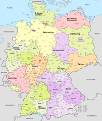
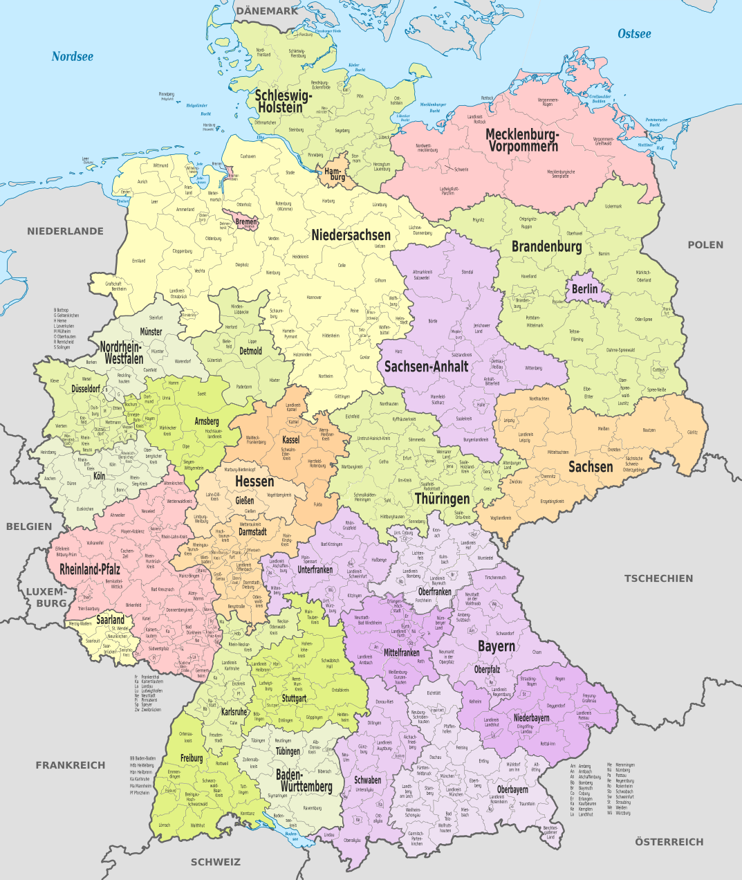
Map of administrative divisions of Germany. States, government districts, districts and district-free towns.
Summary
edit_-_de_-_colored.svg&action=edit§ion=1)
| Description |
Deutsch: Karte der politischen Gliederung Deutschlands in Länder, Regierungsbezirke, Landkreise und krsfr. Städte
English: Map of administrative divisions of Germany. States, government districts, districts and district-free towns. |
||
| Date | |||
| Source |
Own work This W3C-unspecified vector image was created with Adobe Illustrator. This SVG file was uploaded with Commonist. This vector image includes elements that have been taken or adapted from this file: This vector image includes elements that have been taken or adapted from this file: |
||
| Author |
TUBS |
||
| Other versions |
_location_map.svg)
|
Licensing
edit_-_de_-_colored.svg&action=edit§ion=2)
I, the copyright holder of this work, hereby publish it under the following licenses:
This file is licensed under the Creative Commons Attribution-Share Alike 3.0 Unported license.
- You are free:
- to share – to copy, distribute and transmit the work
- to remix – to adapt the work
- Under the following conditions:
- attribution – You must give appropriate credit, provide a link to the license, and indicate if changes were made. You may do so in any reasonable manner, but not in any way that suggests the licensor endorses you or your use.
- share alike – If you remix, transform, or build upon the material, you must distribute your contributions under the same or compatible license as the original.

|
Permission is granted to copy, distribute and/or modify this document under the terms of the GNU Free Documentation License, Version 1.2 or any later version published by the Free Software Foundation; with no Invariant Sections, no Front-Cover Texts, and no Back-Cover Texts. A copy of the license is included in the section entitled GNU Free Documentation License. |
You may select the license of your choice.

|
I'd greatly appreciate, that you attribute this media file to Wikimedia Commons, if used outside Wikipedia or Commons. For use in publications such as books, newspapers, blogs, websites, please insert here the following line:
|
_-_de_-_colored.svg)
File history
Click on a date/time to view the file as it appeared at that time.
| Date/Time | Thumbnail | Dimensions | User | Comment | |
|---|---|---|---|---|---|
| current | 09:04, 7 December 2021 | | 1,073 × 1,272 (4.2 MB) | TUBS (talk | contribs) | erlangen + höchstadt vereint |
| 08:46, 7 December 2021 |  | 1,073 × 1,272 (4.15 MB) | TUBS (talk | contribs) | ||
| 19:56, 3 July 2021 |  | 1,073 × 1,272 (6.08 MB) | NordNordWest (talk | contribs) | upd | |
| 14:12, 6 November 2016 |  | 1,073 × 1,272 (6.05 MB) | NordNordWest (talk | contribs) | upd | |
| 16:28, 9 December 2013 |  | 1,073 × 1,272 (6.02 MB) | TUBS (talk | contribs) | rv lass mal eine Version mit den ganzen Ebenen so. Hilft bei der Aktualisierung. Speicher deine neue (tolle) Version bitte unter anderem Namen | |
| 13:19, 9 December 2013 |  | 9,463 × 12,526 (3.57 MB) | Mapmaster (talk | contribs) | Größer, weniger Ebenen | |
| 12:24, 9 December 2013 |  | 1,073 × 1,272 (6.02 MB) | Mapmaster (talk | contribs) | Landkreis Kehlheim -> Niederbayern | |
| 11:35, 9 December 2013 |  | 1,073 × 1,272 (6 MB) | Mapmaster (talk | contribs) | Landkreis Fulda -> Regierungsbezirk Kassel | |
| 13:07, 29 October 2013 |  | 1,073 × 1,272 (5.98 MB) | TUBS (talk | contribs) | trischen>holstein | |
| 12:59, 29 October 2013 |  | 1,073 × 1,272 (5.98 MB) | TUBS (talk | contribs) | == {{int:filedesc}} == {{Information |Description={{de|Karte der politischen Gliederung Deutschlands in Länder, Regierungsbezirke, Landkreise und krsfr. Städte}} {{en|Map of administrative divisions of Germany. States, government districts, districts... |
You cannot overwrite this file.
File usage on Commons
The following 4 pages use this file:
File usage on other wikis
The following other wikis use this file:
- Usage on ar.wikipedia.org
- Usage on be.wikipedia.org
- Usage on bg.wikipedia.org
- Usage on de.wikipedia.org
- Usage on de.wiktionary.org
- Usage on el.wikipedia.org
- Usage on en.wikipedia.org
- Usage on fi.wikipedia.org
- Usage on fr.wiktionary.org
- Usage on hu.wikipedia.org
- Usage on ia.wikipedia.org
- Usage on it.wikipedia.org
- Usage on lb.wikipedia.org
- Usage on mk.wikipedia.org
- Usage on nl.wikipedia.org
- Usage on ro.wikipedia.org
- Usage on rue.wikipedia.org
- Usage on sr.wikipedia.org
- Usage on vec.wikipedia.org
- Usage on www.wikidata.org
- Usage on zh.wikipedia.org
_-_de_-_colored.svg&oldid=634140147)