File:Germany sorbian region.png
No higher resolution available.
Germany_sorbian_region.png (188 × 235 pixels, file size: 3 KB, MIME type: image/png)
Captions
Captions
Add a one-line explanation of what this file represents
Summary edit
| Description |
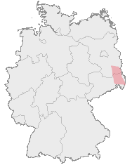
Deutsch: Karte von Deutschland mit den Grenzen der Bundesländer und dem ungefähren Verbreitungegebiet der Sorben rot markiert.
Hornjoserbsce: Korta z čerwjenje markěrowanym sydlenskim rumom Serbow.
English: Map of Germany with borders of its federal states and the red marked region where the Sorbs are living.
Español: En rojo la región aproximada donde viven los sorabos, superpuesta al mapa federal alemán. |
| Source | Map drawn by User:Dabbelju on basis of Maps generated with http://www.opengeodb.de. |
| Author | User:Dabbelju |
| Permission (Reusing this file) |
GFDL |
Licensing edit

|
Permission is granted to copy, distribute and/or modify this document under the terms of the GNU Free Documentation License, Version 1.2 or any later version published by the Free Software Foundation; with no Invariant Sections, no Front-Cover Texts, and no Back-Cover Texts. A copy of the license is included in the section entitled GNU Free Documentation License. |
| This file is licensed under the Creative Commons Attribution-Share Alike 3.0 Unported license. | ||
| ||
| This licensing tag was added to this file as part of the GFDL licensing update. |
File history
Click on a date/time to view the file as it appeared at that time.
| Date/Time | Thumbnail | Dimensions | User | Comment | |
|---|---|---|---|---|---|
| current | 20:10, 29 August 2007 | | 188 × 235 (3 KB) | 32X (talk | contribs) | updated by using Image:Karte Deutschland.png, added transparency |
| 21:16, 15 November 2005 |  | 188 × 235 (5 KB) | Dabbelju (talk | contribs) | ==Description== {{deutsch}} Karte von Deutschland mit den Grenzen der Bundesländer und dem rot markierten Lebensraum der Sorben. {{english}} Map of Germany with borders of its federal states and the red marked region where the [[:en:Sorbs |
You cannot overwrite this file.
File usage on Commons
There are no pages that use this file.
File usage on other wikis
The following other wikis use this file:
- Usage on ar.wikipedia.org
- Usage on ast.wikipedia.org
- Usage on ba.wikipedia.org
- Usage on be-tarask.wikipedia.org
- Usage on br.wikipedia.org
- Usage on bs.wikipedia.org
- Usage on cs.wikipedia.org
- Usage on cy.wikipedia.org
- Usage on da.wikipedia.org
- Usage on de.wikipedia.org
- Usage on dsb.wikipedia.org
- Usage on en.wikipedia.org
- Usage on eo.wikipedia.org
- Usage on et.wikipedia.org
- Usage on fa.wikipedia.org
- Usage on fr.wikipedia.org
- Usage on fur.wikipedia.org
- Usage on fy.wikipedia.org
- Usage on hr.wikipedia.org
- Usage on hsb.wikipedia.org
- Usage on hu.wikipedia.org
- Usage on io.wikipedia.org
- Usage on ja.wikipedia.org
- Usage on lt.wikipedia.org
- Usage on mn.wikipedia.org
- Usage on oc.wikipedia.org
- Usage on pl.wikipedia.org
- Usage on ru.wikipedia.org
- Usage on sv.wikipedia.org
- Usage on uk.wikipedia.org
- Usage on xmf.wikipedia.org