File:Gochang-map.png

Size of this preview: 611 × 599 pixels. Other resolutions: 245 × 240 pixels | 489 × 480 pixels | 783 × 768 pixels | 1,044 × 1,024 pixels | 1,500 × 1,471 pixels.
Original file (1,500 × 1,471 pixels, file size: 590 KB, MIME type: image/png)
Captions
Captions
Add a one-line explanation of what this file represents
Summary edit
| Description |
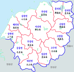
한국어: 고창군 행정구역도 |
| Date | |
| Source | Own work |
| Author | 장길산 |
Licensing edit
| I, the copyright holder of this work, release this work into the public domain. This applies worldwide. In some countries this may not be legally possible; if so: I grant anyone the right to use this work for any purpose, without any conditions, unless such conditions are required by law. |
File history
Click on a date/time to view the file as it appeared at that time.
| Date/Time | Thumbnail | Dimensions | User | Comment | |
|---|---|---|---|---|---|
| current | 03:37, 30 December 2021 | | 1,500 × 1,471 (590 KB) | Magog the Ogre (talk | contribs) | Reverted to version as of 23:14, 16 August 2012 (UTC) |
| 23:14, 16 August 2012 |  | 1,500 × 1,471 (590 KB) | Asfreeas (talk | contribs) | 색상정리 배경 지역 추가 | |
| 15:20, 26 December 2011 |  | 1,500 × 1,471 (668 KB) | Gloyacks (talk | contribs) | {{파일 정보 |설명=고창군 행정구역도 |출처=자작 |날짜=2011년 12월 26일 |만든이=장길산 |저작권= |기타= }} |
You cannot overwrite this file.
File usage on Commons
The following 2 pages use this file:
File usage on other wikis
The following other wikis use this file:
- Usage on frr.wikipedia.org
- Usage on ja.wikipedia.org
- Usage on www.wikidata.org