File:Golan heights rel89B.jpg

Size of this preview: 468 × 599 pixels. Other resolutions: 187 × 240 pixels | 375 × 480 pixels | 1,022 × 1,308 pixels.
Original file (1,022 × 1,308 pixels, file size: 231 KB, MIME type: image/jpeg)
Captions
Captions
Add a one-line explanation of what this file represents
Summary edit
| Description |
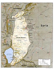
English: I created this image myself, by modifying the existing Image:Golan_heights_rel89A.jpg, which was itself a modified version of a modified CIA (and hence public domain) Image:Golan_92.jpg. Previous modifications were done to provide a map that was impartial about the contentious issue of which country owns the Golan Heights. The previous modifications were effective in creating a neutral map by removing the names "Syria" and "Israel" from the contentious territory and left only the label "Golan Heights". The present modification was intended solely to restore the names and locations of villages that were included on the original CIA map but had been (inadvertently) moved or erased by relocating the country titles. Due to the recurrent conflict involving villages and settlements within the Golan Heights, I feel that it is important to retain the locations on the map. As with the earlier modifications of this file, I hope that this modification will be seen as a fair compromise that also maintains the cartographical accuracy of map. I make no copyright claim on my modification; its copyright status is the same as its source. dp_roberson 15:44, 21 October 2007 (UTC) |
| Date | 21 September 2007 (original upload date) |
| Source | Transferred from en.wikipedia to Commons. |
| Author | Dp roberson at English Wikipedia |
Licensing edit
| This work has been released into the public domain by its author, Dp roberson at English Wikipedia. This applies worldwide. In some countries this may not be legally possible; if so: Dp roberson grants anyone the right to use this work for any purpose, without any conditions, unless such conditions are required by law. |
Original upload log edit
The original description page was here. All following user names refer to en.wikipedia.
- 2008-12-29 03:13 كهيعص 1022×1308× (236080 bytes) added 4 villages to the map
- 2007-09-21 15:45 Dp roberson 1022×1308× (226330 bytes) I created this image myself, by modifying the existing Image:Golan_heights_rel89A.jpg, which was itself a modified version of a modified CIA (and hence public domain) Image:Golan_92.jpg. Previous modifications were done to provide a map that was impartia
File history
Click on a date/time to view the file as it appeared at that time.
| Date/Time | Thumbnail | Dimensions | User | Comment | |
|---|---|---|---|---|---|
| current | 04:56, 27 January 2015 | | 1,022 × 1,308 (231 KB) | Magog the Ogre (talk | contribs) | Reverted to version as of 22:56, 25 January 2015 |
| 22:56, 25 January 2015 |  | 468 × 599 (257 KB) | OgreBot (talk | contribs) | (BOT): Reverting to most recent version before archival | |
| 22:56, 25 January 2015 |  | 1,022 × 1,308 (231 KB) | OgreBot (talk | contribs) | (BOT): Uploading old version of file from en.wikipedia; originally uploaded on 2008-12-29 03:13:42 by كهيعص | |
| 13:20, 22 September 2010 |  | 468 × 599 (257 KB) | Ravpapa (talk | contribs) | Added the words "(Israeli occupied)" under the words "Golan Heights". This makes it clear that the area is occupied. | |
| 08:53, 5 March 2008 |  | 1,022 × 1,308 (221 KB) | Cansado (talk | contribs) | {{Information |Description={{en|I created this image myself, by modifying the existing Image:Golan_heights_rel89A.jpg, which was itself a modified version of a modified CIA (and hence public domain) Image:Golan_92.jpg. Previous modifications were done to |
You cannot overwrite this file.
File usage on Commons
There are no pages that use this file.
File usage on other wikis
The following other wikis use this file:
- Usage on ar.wikipedia.org
- Usage on ba.wikipedia.org
- Usage on de.wikinews.org
- Usage on en.wikipedia.org
- Usage on ru.wikipedia.org
- Usage on tr.wikipedia.org