File:Gustavus Nicolls 1816 plan of Fort York - e007140722LAC.jpg
Original file (7,348 × 6,360 pixels, file size: 2.14 MB, MIME type: image/jpeg)
Captions
Captions
Summary
edit| Description |
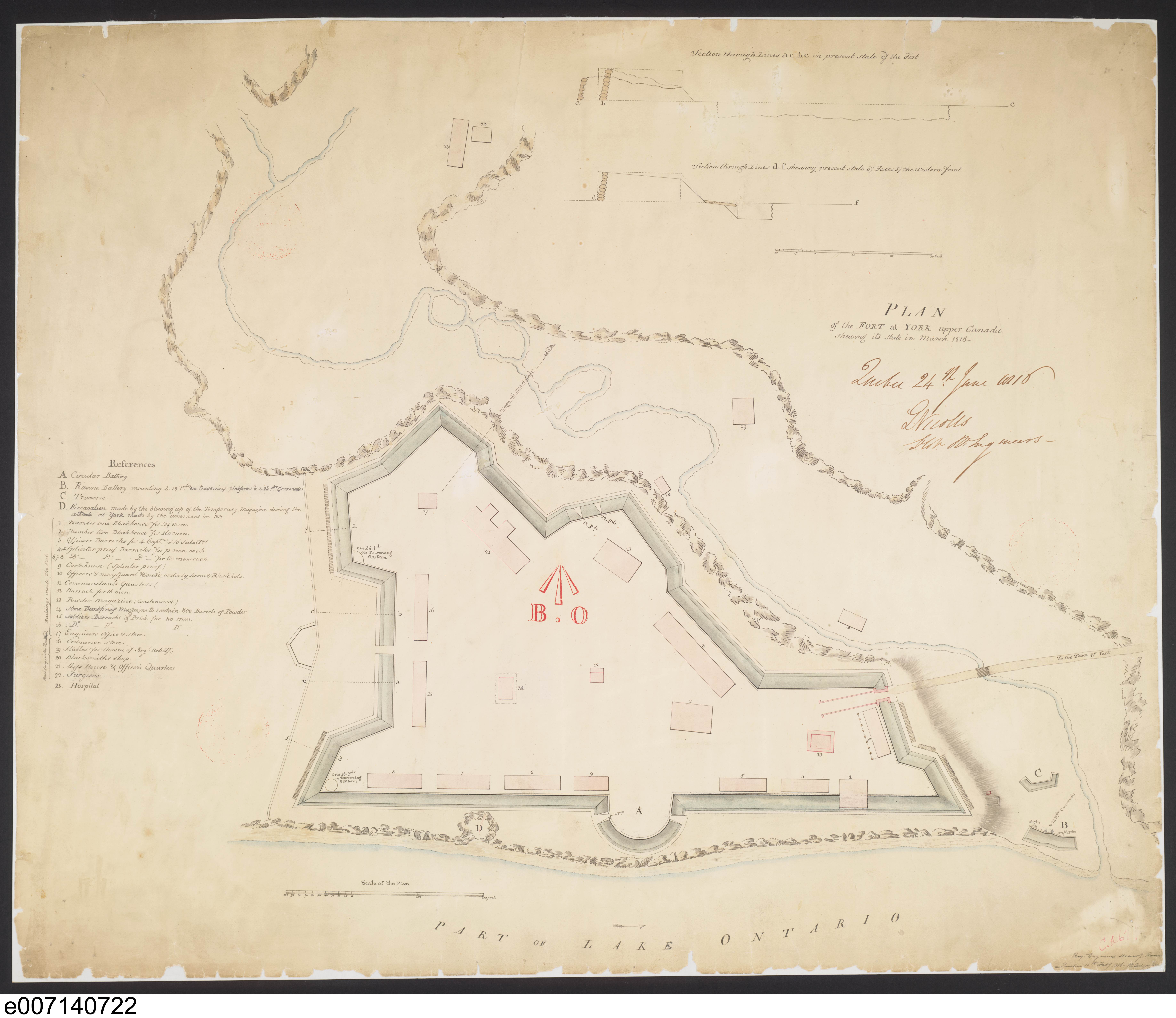
English: “After the War of 1812, Fort York was rebuilt to provide quarters for 950 men within a defensive wall. Today’s Old Fort York reconstructs the fort of this period.
Image courtesy Library and Archives Canada: NMC 22819. Winearls, MUC no. 2035Note the defensive position of the fort, which was located on a bluff above the lakeshore and protected by Garrison Creek ravine. Later fill has extended the shore and changed the surrounding topography. The crater at the lakeshore caused by the explosion of the powder magazine in 1813 is marked by 'D'. ” - Isobel Ganton & Joan Winearls, MAPPING TORONTO'S FIRST CENTURY 1787-1884 |
|||||||||||
| Date | ||||||||||||
| Source | http://oldtorontomaps.blogspot.com/2013/01/1816-nicolls-plan-of-fort-at-york-upper.html | |||||||||||
| Author |
|
|||||||||||
| Permission (Reusing this file) |
|
|||||||||||


File history
Click on a date/time to view the file as it appeared at that time.
| Date/Time | Thumbnail | Dimensions | User | Comment | |
|---|---|---|---|---|---|
| current | 14:14, 16 June 2021 | | 7,348 × 6,360 (2.14 MB) | Geo Swan (talk | contribs) | {{Information |Description={{en|1=“After the War of 1812, Fort York was rebuilt to provide quarters for 950 men within a defensive wall. Today’s Old Fort York reconstructs the fort of this period. Note the defensive position of the fort, which was located on a bluff above the lakeshore and protected by Garrison Creek ravine. Later fill has extended the shore and changed the surrounding topography. The crater at the lakeshore caused by the explosion of the powder magazine in 1813 is marked b... |
You cannot overwrite this file.
File usage on Commons
There are no pages that use this file.
File usage on other wikis
The following other wikis use this file:
- Usage on en.wikipedia.org