File:HUA-214097-Plattegrond van het door de Staten van Utrecht van de stad Utrecht aangekochte perceel grond voorheen het St Ceciliaklooster gelegen tussen de Oudegra.jpg

Size of this preview: 676 × 600 pixels. Other resolutions: 271 × 240 pixels | 541 × 480 pixels | 866 × 768 pixels | 1,154 × 1,024 pixels | 2,308 × 2,048 pixels | 4,558 × 4,044 pixels.
Original file (4,558 × 4,044 pixels, file size: 3.55 MB, MIME type: image/jpeg)
Captions
Captions
Add a one-line explanation of what this file represents
Summary
edit| Description |
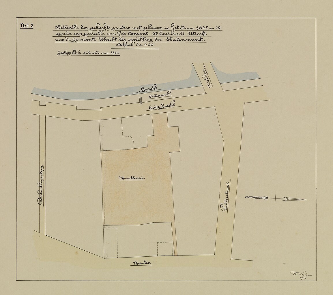
Nederlands: Plattegrond van het door de Staten van Utrecht van de stad Utrecht aangekochte perceel grond (voorheen het St. Ceciliaklooster), gelegen tussen de Oudegracht en de Neude te Utrecht, ten behoeve van de vestiging van de Statenmunt (Rijksmunt); met intekening van de perceelsgrenzen in 1823. |
|||||||||||||||||
| Date | between 1 January 1647 and 31 December 1648 | |||||||||||||||||
| Source | https://hetutrechtsarchief.nl/beeld/944A24128A13531FA94333FACC10FF8D | |||||||||||||||||
| Creator |
Verlaan, Th., tekenaar |
|||||||||||||||||
| Geotemporal data | ||||||||||||||||||
| Scale |
Nederlands: 1:400 |
|||||||||||||||||
| Georeferencing | If inappropriate please set warp_status = skip to hide. | |||||||||||||||||
| Archival data | ||||||||||||||||||
| Collection |
|
|||||||||||||||||
| Accession number |
GUID: 944A24128A13531FA94333FACC10FF8D, HUA Catalogusnummer: 214097 |
|||||||||||||||||
| Dimensions | height: 35 cm (13.7 in); width: 40 cm (15.7 in) | |||||||||||||||||
| Medium |
Nederlands: pen in zwart, penseel in kleur (waterverf) |
|||||||||||||||||
| Inscriptions |
Nederlands: "Situatie der gekochte gronden met gebouwen in het jaar 1647 en 48 zynde een gedeelte van het convent St. Cecilia te Utrecht van de Gemeente Utrecht ter oprichting der Statenmunt." |
|||||||||||||||||
| Notes |
Nederlands: Een in 1919 door Th. Verlaan vervaardigde reconstructietekening naar de situatie in 1647/1648, het jaar van de vestiging van de Statenmunt. Tussen 1919 en 1925 werd op deze locatie het nieuwe post-, telegraaf- en telefoonkantoor gebouwd. |
|||||||||||||||||

Licensing
edit
|
This work is in the public domain in its country of origin and other countries and areas where the copyright term is the author's life plus 70 years or fewer. | |
| This file has been identified as being free of known restrictions under copyright law, including all related and neighboring rights. | |
This media file is from the collections of the Het Utrechts Archief. This tag does not indicate the copyright status of the attached work. A normal copyright tag is still required. See Commons:Licensing.
|
File history
Click on a date/time to view the file as it appeared at that time.
| Date/Time | Thumbnail | Dimensions | User | Comment | |
|---|---|---|---|---|---|
| current | 16:44, 15 February 2021 | | 4,558 × 4,044 (3.55 MB) | CompanjeBot (talk | contribs) | Uploading image from Het Utrechts Archief: https://hetutrechtsarchief.nl/beeld/944A24128A13531FA94333FACC10FF8D |
You cannot overwrite this file.
File usage on Commons
There are no pages that use this file.