File:Hahnenkopf Faschina.jpg

Size of this preview: 800 × 417 pixels. Other resolutions: 320 × 167 pixels | 640 × 334 pixels | 1,024 × 534 pixels | 1,280 × 667 pixels | 2,844 × 1,483 pixels.
Original file (2,844 × 1,483 pixels, file size: 887 KB, MIME type: image/jpeg)
Captions
Captions
Add a one-line explanation of what this file represents
Summary edit

|
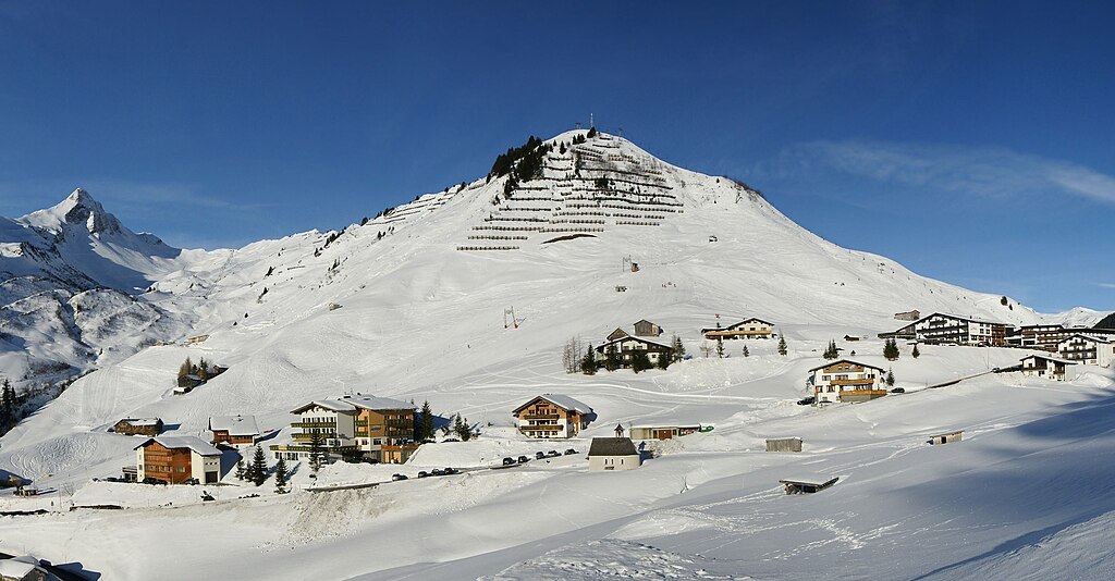
NOTE: This image is a panorama consisting of multiple frames that were merged or stitched in software. As a result, this image necessarily underwent some form of digital manipulation. These manipulations may include blending, blurring, cloning, and colour and perspective adjustments. As a result of these adjustments, the image content may be slightly different from reality at the points where multiple images were combined. This manipulation is often required due to lens, perspective, and parallax distortions.
|
| Description |
Deutsch: Blick vom Fusse des Zafernhorn im Ortsgebiet von Fontanella - Faschina auf links die Bettlerspitze, Rote Wand 2.704m, Formarin Rothorn, Glattmahd dem Gronggenkopf und der Kellaspitze. Die Bildmitte zeigt das Sonnenköpfle. Der markante Spitz ist der höchste Berg des Bregenzerwaldgebirges: das Glatthorn 2.134m. Der Hahnenkopf ist mit Lawinenfangzäunen verbaut. In der rechten Bildecke sieht man ganz klein der Hochblanken, das Hohe Licht, die Damülser Mittagspitze und zum Schluß der Elsenkopf auf den der Ugalift hinaufführt. Über das Faschina Joch gelangt man auf Damüls und in den Bregenzerwald. Über die Faschina Straße fährt man links hinunter in das Große Walsertal. English: View from the foot of the Zafernhorn in the area of Fontanella-Faschina, from left to right the Bettlerspitze, Rote Wand (2,704 m), Formarin Rothorn, Glattmahd dem Gronggenkopf and the Kellaspitze. The centre of the picture shows the Sonnenköpfle. The prominent peak is the highest mountain of the Bregenzerwaldgebirge: the Glatthorn (2,134 m). The Hahnenkopf is blocked with avanlanche barriers. In the right edge of the photo you can see very small the Hochblanken, the Hohe Licht, the Damülser Mittagsspitze and finally the Elsenkopf, up to which leads the Ugalift. Over the col Faschina you can get to Damüls and into the Bregenzerwald. Over the street Faschina you drive to the left down to the Great Walsertal. Français : Vue de montagnes depuis le pied du Zafernhorn dans la région autrichienne de Fontanella. Au centre de la photo est le Sonnenköpfle, alors que le sommet plus élevé à la droite est le Glatthorn qui culmine à 2 134 m. |
| Date | |
| Source | Own work |
| Author | böhringer friedrich |
| Permission (Reusing this file) |
I, the copyright holder of this work, hereby publish it under the following license: This file is licensed under the Creative Commons Attribution-Share Alike 2.5 Generic license.
|
| Other versions |
| Camera location | | View this and other nearby images on: OpenStreetMap |
|---|
Licensing edit
This Photo was taken by Böhringer Friedrich.
|
Feel free to use my photos, but please mention me as the author and if you want send me a message. or (rufre@lenz-nenning.at) |
File history
Click on a date/time to view the file as it appeared at that time.
| Date/Time | Thumbnail | Dimensions | User | Comment | |
|---|---|---|---|---|---|
| current | 18:28, 25 February 2024 | | 2,844 × 1,483 (887 KB) | Herzi Pinki (talk | contribs) | File:Faschina Panorama.jpg cropped 63 % horizontally, 30 % vertically using CropTool with precise mode. |
You cannot overwrite this file.
File usage on Commons
The following 2 pages use this file:
File usage on other wikis
The following other wikis use this file:
- Usage on ceb.wikipedia.org
- Usage on de.wikipedia.org
- Usage on www.wikidata.org