File:Holocaust Jewish death toll %.svg

Size of this PNG preview of this SVG file: 592 × 600 pixels. Other resolutions: 237 × 240 pixels | 474 × 480 pixels | 758 × 768 pixels | 1,010 × 1,024 pixels | 2,021 × 2,048 pixels | 2,000 × 2,027 pixels.
Original file (SVG file, nominally 2,000 × 2,027 pixels, file size: 983 KB)
Captions
Captions
Add a one-line explanation of what this file represents
Summary
edit
| Description |
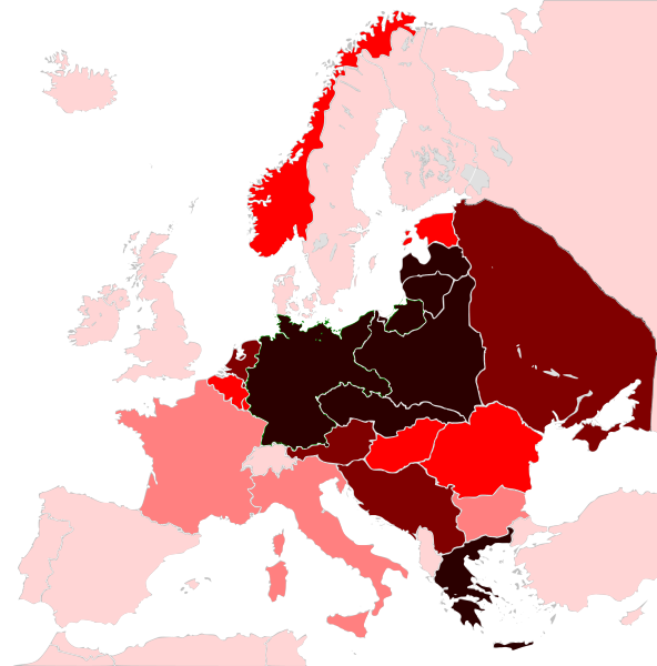
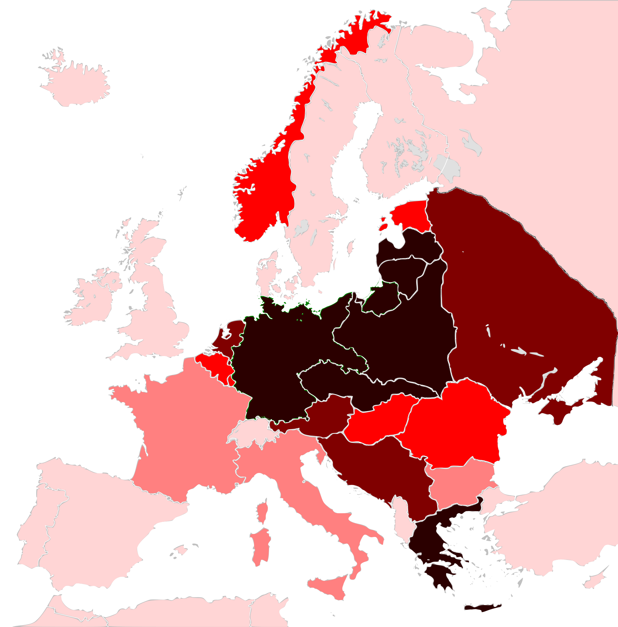
Map of the Jewish Holocaust death toll as a % of the total pre-war Jewish population by country/region
|
| Date | (UTC) |
| Source |
This file was derived from: Weimar Republic 1930.svg:  |
| Author |
|
| This is a retouched picture, which means that it has been digitally altered from its original version. Modifications: Used it to make a Holocaust death toll (%) by country/area. The original can be viewed here: Weimar Republic 1930.svg:
|
Licensing
edit
I, the copyright holder of this work, hereby publish it under the following license:
This file is licensed under the Creative Commons Attribution-Share Alike 3.0 Unported license.
- You are free:
- to share – to copy, distribute and transmit the work
- to remix – to adapt the work
- Under the following conditions:
- attribution – You must give appropriate credit, provide a link to the license, and indicate if changes were made. You may do so in any reasonable manner, but not in any way that suggests the licensor endorses you or your use.
- share alike – If you remix, transform, or build upon the material, you must distribute your contributions under the same or compatible license as the original.
Original upload log
edit
This image is a derivative work of the following images:
- File:Weimar_Republic_1930.svg licensed with Cc-by-sa-3.0
- 2011-10-27T03:00:17Z Alphathon 450x456 (480732 Bytes) Minor tweak
- 2011-10-27T02:49:21Z Alphathon 450x456 (480434 Bytes) Tweaked Romanian borders
- 2011-10-27T02:30:44Z Alphathon 450x456 (476278 Bytes) A few minor fixes (Malta grouped with UK, North Cyprus removed, a few Greek islands moved to Italy per 1930 ownership).
- 2011-10-27T02:10:50Z Alphathon 450x456 (477608 Bytes) == {{int:filedesc}} == {{Information |Description={{en|A Map of the Weimar Republic within Europe circa 1930.}} |Source=*[[:File:Blank_map_of_Europe.svg|]] |Date=2011-10-27 02:10 (UTC) |Author=*[[:File:Blank_map_of_Europe.svg
Uploaded with derivativeFX
File history
Click on a date/time to view the file as it appeared at that time.
| Date/Time | Thumbnail | Dimensions | User | Comment | |
|---|---|---|---|---|---|
| current | 23:09, 15 August 2012 | | 2,000 × 2,027 (983 KB) | Futurist110 (talk | contribs) | Fixed map. Sources: *http://frank.mtsu.edu/~baustin/jewvicts.html (for the countries listed in this link) *http://www.ahbjewishcenter.org/hashoah05stat.htm (for the other countries not mentioned in the other link) Very light pink: 0-1% of pre-war Jew... |
| 22:10, 25 July 2012 |  | 744 × 1,052 (1.57 MB) | Futurist110 (talk | contribs) | Added legend details | |
| 22:02, 25 July 2012 |  | 744 × 1,052 (1.57 MB) | Futurist110 (talk | contribs) | Added legend | |
| 21:00, 25 July 2012 |  | 744 × 1,052 (1.26 MB) | Futurist110 (talk | contribs) | Got rid of map errors | |
| 20:39, 25 July 2012 |  | 744 × 1,052 (960 KB) | Futurist110 (talk | contribs) | == {{int:filedesc}} == {{Information |Description={{en|Map of the Weimar Republic within Europe circa 1930.}}{{de|Karte der Weimarer Republik/Deutsches Reich innerhalb Europa, ca. 1930}} |Source={{Derived from|Weimar_Republic_1930.svg|display=50}} |Dat... |
You cannot overwrite this file.
File usage on Commons
The following page uses this file:
- File:Holocaustdeathtoll%.svg (file redirect)