File:Hopsten Brenninkmeyerstrasse 11.jpg
![File:Hopsten Brenninkmeyerstrasse 11.jpg](https://upload.wikimedia.org/wikipedia/commons/thumb/8/8f/Hopsten_Brenninkmeyerstrasse_11.jpg/483px-Hopsten_Brenninkmeyerstrasse_11.jpg?20170722074906)
Size of this preview: 483 × 599 pixels. Other resolutions: 193 × 240 pixels | 387 × 480 pixels | 619 × 768 pixels | 825 × 1,024 pixels | 1,651 × 2,048 pixels | 3,319 × 4,117 pixels.
Original file (3,319 × 4,117 pixels, file size: 8.51 MB, MIME type: image/jpeg)
File information
Structured data
Captions
Captions
Add a one-line explanation of what this file represents
Summary
editDescriptionHopsten Brenninkmeyerstrasse 11.jpg |
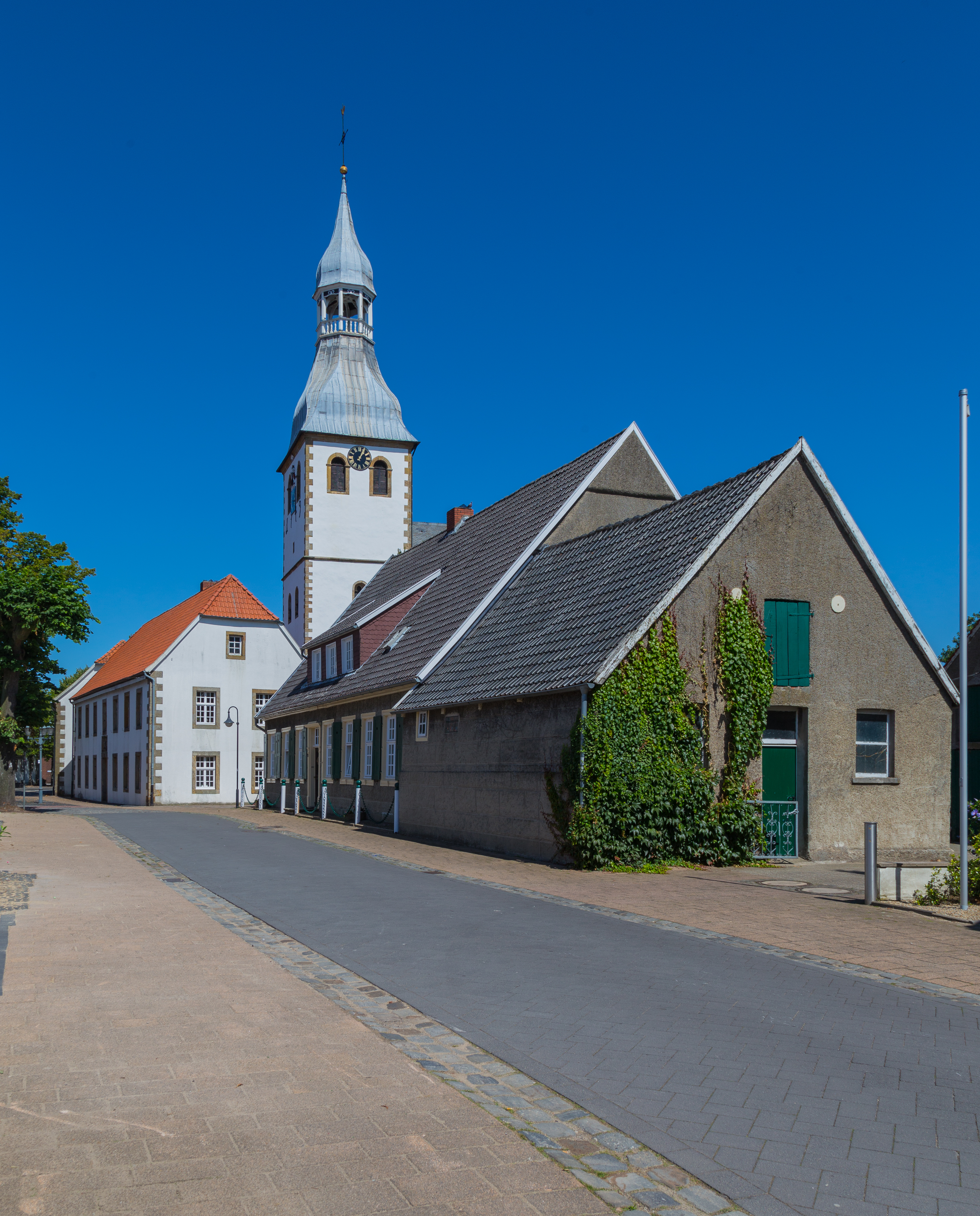
Deutsch: Brenninkmeyer Street (Brenninkmeyerstraße) in Hopsten, Kreis Steinfurt, North Rhine-Westphalia, Germany. In the background one can see the tower of the Roman Catholic St George Parish Church.
Deutsch: Die Brenninkmeyerstraße im Ortskern von Hopsten, Kreis Steinfurt, Nordrhein-Westfalen, Deutschland. Das frühere Kopfsteinpflaster wurde 2013 im Zuge einer Umgestaltung eines Abschnitts der Straße durch Betonsteinpflaster ersetzt. Dies soll die Barrierefreiheit dort erhöhen. Im Hintergrund ragt der Turm der Pfarrkirche St. Georg auf.
|
||||||
Date | |||||||
Source | Own work | ||||||
Author | J.-H. Janßen |
Camera location | 52° 22′ 56.93″ N, 7° 36′ 14.73″ E ![]() | View this and other nearby images on: OpenStreetMap | ![]() |
---|
Licensing
edit![w:en:Creative Commons](https://upload.wikimedia.org/wikipedia/commons/thumb/7/79/CC_some_rights_reserved.svg/90px-CC_some_rights_reserved.svg.png)
![attribution](https://upload.wikimedia.org/wikipedia/commons/thumb/1/11/Cc-by_new_white.svg/24px-Cc-by_new_white.svg.png)
![share alike](https://upload.wikimedia.org/wikipedia/commons/thumb/d/df/Cc-sa_white.svg/24px-Cc-sa_white.svg.png)
This file is licensed under the Creative Commons Attribution-Share Alike 4.0 International license.
- You are free:
- to share – to copy, distribute and transmit the work
- to remix – to adapt the work
- Under the following conditions:
- attribution – You must give appropriate credit, provide a link to the license, and indicate if changes were made. You may do so in any reasonable manner, but not in any way that suggests the licensor endorses you or your use.
- share alike – If you remix, transform, or build upon the material, you must distribute your contributions under the same or compatible license as the original.
File history
Click on a date/time to view the file as it appeared at that time.
Date/Time | Thumbnail | Dimensions | User | Comment | |
---|---|---|---|---|---|
current | 07:49, 22 July 2017 | ![]() | 3,319 × 4,117 (8.51 MB) | J.-H. Janßen (talk | contribs) | {{Information |Description ={{de|1=Brenninkmeyer Street (''Brenninkmeyerstraße'') in Hopsten, Kreis Steinfurt, North Rhine-Westphalia, Germany. In the background one can see the tower of the Roman Catholic St George Parish Church.}}... |
You cannot overwrite this file.
File usage on Commons
The following page uses this file:
Metadata
This file contains additional information such as Exif metadata which may have been added by the digital camera, scanner, or software program used to create or digitize it. If the file has been modified from its original state, some details such as the timestamp may not fully reflect those of the original file. The timestamp is only as accurate as the clock in the camera, and it may be completely wrong.
Camera manufacturer | Canon |
---|---|
Camera model | Canon EOS 6D |
Author | Wikimedia User J.-H. Janssen |
Exposure time | 1/160 sec (0.00625) |
F-number | f/11 |
ISO speed rating | 100 |
Date and time of data generation | 13:04, 9 August 2015 |
Lens focal length | 24 mm |
Latitude | 52° 22′ 56.93″ N |
Longitude | 7° 36′ 14.74″ E |
Altitude | 50.9 meters above sea level |
City shown | Hopsten |
Horizontal resolution | 300 dpi |
Vertical resolution | 300 dpi |
Software used | Adobe Photoshop Lightroom 5.7.1 (Windows) |
File change date and time | 19:31, 21 July 2017 |
Exposure Program | Landscape mode (for landscape photos with the background in focus) |
Exif version | 2.3 |
Date and time of digitizing | 13:04, 9 August 2015 |
APEX shutter speed | 7.321928 |
APEX aperture | 6.918863 |
APEX exposure bias | 0 |
Maximum land aperture | 4 APEX (f/4) |
Metering mode | Pattern |
Flash | Flash did not fire, compulsory flash suppression |
DateTimeOriginal subseconds | 00 |
DateTimeDigitized subseconds | 00 |
Color space | sRGB |
Focal plane X resolution | 1,520 |
Focal plane Y resolution | 1,520 |
Focal plane resolution unit | 3 |
Custom image processing | Normal process |
Exposure mode | Auto exposure |
White balance | Auto white balance |
Scene capture type | Standard |
GPS time (atomic clock) | 11:04 |
Satellites used for measurement | 12 |
Receiver status | Measurement in progress |
Measurement mode | 3-dimensional measurement |
Measurement precision | Poor (4.3) |
Geodetic survey data used | WGS-84 |
GPS date | 9 August 2015 |
GPS tag version | 0.0.3.2 |
Serial number of camera | 033024001627 |
Lens used | EF24-105mm f/4L IS USM |
Date metadata was last modified | 21:31, 21 July 2017 |
Unique ID of original document | 1B405461F4409C8E77614FD7BDF8D162 |
Province or state shown | Nordrhein-Westfalen |
Country shown | Deutschland |
Sublocation of city shown | Nordrhein-Westfalen |
IIM version | 4 |