File:Inauguracao obras primeira Linha de Sintra - GazetaCF 1105 1934.jpg
(Redirected from File:Inauguration of the works of the first Sintra Railway.jpg)

Size of this preview: 800 × 349 pixels. Other resolutions: 320 × 140 pixels | 839 × 366 pixels.
Original file (839 × 366 pixels, file size: 340 KB, MIME type: image/jpeg)
Captions
Captions
Add a one-line explanation of what this file represents
Summary edit
| Description |
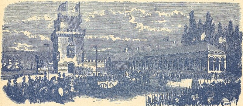
Português: Inauguração dos trabalhos no primeiro projecto para um caminho de ferro entre Lisboa e Sintra, em Portugal, em 1855, junto à Torre de Belém. Esta linha devia seguir ao longo do Rio Tejo entre o Forte de São Paulo (que foi demolido e substituído pela Praça de D. Luís) até Algés, onde se dirigiria até Sintra utilizando em parte o vale da Ribeira de Algés. Este projecto foi abandonado, e uma nova linha para Sintra foi concluída em 1887. Partes do traçado da antiga linha são semelhantes às utilizadas pelas Linhas de Sintra e Cascais.
Esta imagem foi publicada na Gazeta dos Caminhos de Ferro n.º 1105, de 1 de Janeiro de 1934, e digitalizada pela Hemeroteca Municipal de Lisboa. English: Inauguration of the works on the first project to a railway connection between Lisbon and Sintra, in Portugal, in 1885. This line was supposed to start from near the São Paulo Fort (that was demolished and replaced by the D. Luís Plaza), and follow the Tagus River until Algés, from where it would go to Sintra, using part of the valley of the Algés River. This project was cancelled, and a new line to Sintra was completed in 1887. Parts of the course of the old line are very similar to the ones used by the Sintra and Cascais Railways.
This image was originally published in the Gazeta dos Caminhos de Ferro No. 1105, of the 1st January 1934, and scanned by the Hemeroteca Municipal de Lisboa. |
| Date | |
| Source | http://hemerotecadigital.cm-lisboa.pt/OBRAS/GazetaCF/1934/N1105/N1105_item1/P38.html |
| Author | Unknown author |
| Camera location | | View this and other nearby images on: OpenStreetMap |
|---|
Licensing edit
This image (or other media file) is in the public domain because its copyright has expired and its author is anonymous.
This applies to the European Union and those countries with a copyright term of 70 years after the work was made available to the public and the author never disclosed their identity. Important: Always mention where the image comes from, as far as possible, and make sure the author never claimed authorship. |
 | |
 |
Note: In Germany and possibly other countries, certain anonymous works published before July 1, 1995 are copyrighted until 70 years after the death of the author. See Übergangsrecht. Please use this template only if the author never claimed authorship or their authorship never became public in any other way. If the work is anonymous or pseudonymous (e.g., published only under a corporate or organization's name), use this template for images published more than 70 years ago.
For a work made available to the public in the United Kingdom, please use Template:PD-UK-unknown instead.
|
File history
Click on a date/time to view the file as it appeared at that time.
| Date/Time | Thumbnail | Dimensions | User | Comment | |
|---|---|---|---|---|---|
| current | 19:18, 22 December 2014 | | 839 × 366 (340 KB) | Ajpvalente (talk | contribs) | User created page with UploadWizard |
You cannot overwrite this file.
File usage on Commons
The following 3 pages use this file:
File usage on other wikis
The following other wikis use this file:
- Usage on it.wikipedia.org
- Usage on pt.wikipedia.org