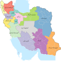
File:Iran provinces and counties 1956.svg

Original file (SVG file, nominally 2,074 × 2,059 pixels, file size: 364 KB)
Captions
Captions
Summary edit
| DescriptionIran provinces and counties 1956.svg |
English: Iran provinces and counties in 1956 based on [1]
فارسی: استانها و شهرستانهای ایران در ۱۳۳۵ [2]
|
||
| Date | |||
| Source |
Own work This file was derived from: National and Province Statistics of the First Census of Iran November 1956 - Vol. 01.pdf |
||
| Author | 4nn1l2 | ||
| Other versions |
|
||
| SVG development InfoField |
Assessment edit
|
Licensing edit
- You are free:
- to share – to copy, distribute and transmit the work
- to remix – to adapt the work
- Under the following conditions:
- attribution – You must give appropriate credit, provide a link to the license, and indicate if changes were made. You may do so in any reasonable manner, but not in any way that suggests the licensor endorses you or your use.
- share alike – If you remix, transform, or build upon the material, you must distribute your contributions under the same or compatible license as the original.
File history
Click on a date/time to view the file as it appeared at that time.
| Date/Time | Thumbnail | Dimensions | User | Comment | |
|---|---|---|---|---|---|
| current | 19:59, 9 November 2020 |  | 2,074 × 2,059 (364 KB) | 4nn1l2 (talk | contribs) | آذ غر |
| 19:52, 9 November 2020 |  | 2,074 × 2,059 (363 KB) | 4nn1l2 (talk | contribs) | editable text, nazli, scour (optimized) | |
| 15:11, 3 November 2020 |  | 2,074 × 2,059 (931 KB) | 4nn1l2 (talk | contribs) | Reverted to version as of 19:40, 2 November 2020 (UTC) | |
| 09:32, 3 November 2020 |  | 2,074 × 2,059 (962 KB) | 4nn1l2 (talk | contribs) | restore sea names | |
| 19:40, 2 November 2020 |  | 2,074 × 2,059 (931 KB) | 4nn1l2 (talk | contribs) | bahrain | |
| 15:50, 2 November 2020 |  | 2,074 × 2,059 (931 KB) | 4nn1l2 (talk | contribs) | rm water body names | |
| 03:53, 29 October 2020 |  | 2,074 × 2,059 (962 KB) | 4nn1l2 (talk | contribs) | gilan for arak, color swap: mazandaran and central | |
| 05:06, 28 October 2020 |  | 2,074 × 2,059 (955 KB) | 4nn1l2 (talk | contribs) | more islands | |
| 05:01, 28 October 2020 |  | 2,074 × 2,059 (955 KB) | 4nn1l2 (talk | contribs) | qeshm, caspian, oman, persian gulf | |
| 13:58, 26 October 2020 |  | 2,074 × 2,059 (924 KB) | 4nn1l2 (talk | contribs) | Uploaded own work with UploadWizard |
You cannot overwrite this file.
File usage on Commons
The following page uses this file:
File usage on other wikis
The following other wikis use this file:
- Usage on fa.wikipedia.org
- آذربایجان
- پیشینه تقسیمات کشوری ایران
- درگاه:خراسان/نگاره برگزیده
- ویکیپدیا:گزیدن نگاره برگزیده/نوامبر-۲۰۲۰
- ویکیپدیا:گزیدن نگاره برگزیده/Iran provinces and counties 1956.svg
- درگاه:خراسان/نگاره برگزیده/۳۴
- ویکیپدیا:نگاره روز/مارس ۲۰۲۳
- اتصال استان فارس به خلیج فارس
- الگو:نر/2023-03-03
- الگو:نر محافظت شده/2023-03-03
- بحث ویکیپدیا:آیا میدانستید که...؟/۲۰۲۳/هفته ۰۸
Metadata
This file contains additional information such as Exif metadata which may have been added by the digital camera, scanner, or software program used to create or digitize it. If the file has been modified from its original state, some details such as the timestamp may not fully reflect those of the original file. The timestamp is only as accurate as the clock in the camera, and it may be completely wrong.
| Short title | Iran administrative divisions in 1956 |
|---|---|
| Width | 585.46mm |
| Height | 580.98mm |
