File:Isewangan 20180203B.png

Size of this preview: 800 × 308 pixels. Other resolutions: 320 × 123 pixels | 640 × 246 pixels | 1,024 × 394 pixels | 1,280 × 493 pixels | 5,000 × 1,925 pixels.
Original file (5,000 × 1,925 pixels, file size: 259 KB, MIME type: image/png)
Captions
Captions
Add a one-line explanation of what this file represents
Summary
edit
| Description |
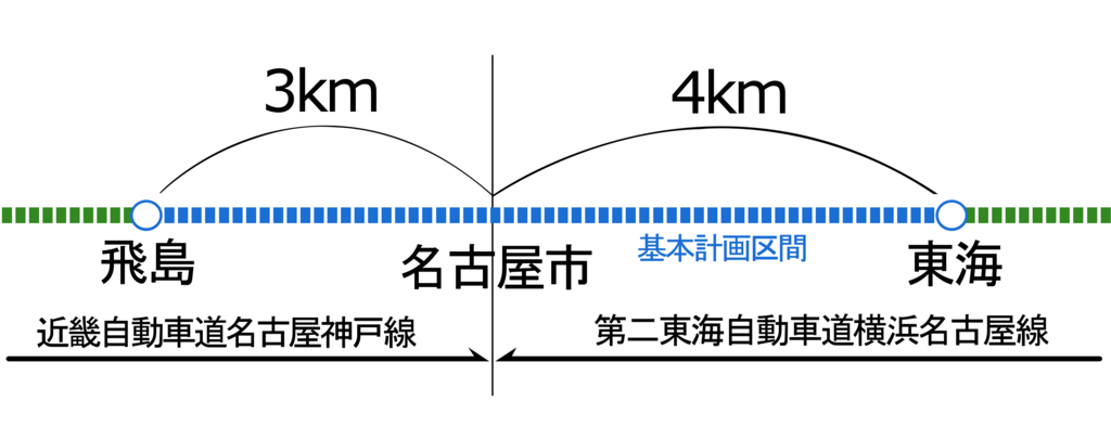
日本語: 1997年基本計画区間に追加された東海 - 飛島間の路線割り振り図。典拠:『高速道路と自動車』公益財団法人高速道路調査会、1997年2月、32 - 37頁。 |
| Date | |
| Source | Own work |
| Author | Oka21000 |
Licensing
edit
I, the copyright holder of this work, hereby publish it under the following license:
This file is licensed under the Creative Commons Attribution-Share Alike 4.0 International license.
- You are free:
- to share – to copy, distribute and transmit the work
- to remix – to adapt the work
- Under the following conditions:
- attribution – You must give appropriate credit, provide a link to the license, and indicate if changes were made. You may do so in any reasonable manner, but not in any way that suggests the licensor endorses you or your use.
- share alike – If you remix, transform, or build upon the material, you must distribute your contributions under the same or compatible license as the original.
File history
Click on a date/time to view the file as it appeared at that time.
| Date/Time | Thumbnail | Dimensions | User | Comment | |
|---|---|---|---|---|---|
| current | 07:54, 3 February 2018 | 5,000 × 1,925 (259 KB) | Oka21000 (talk | contribs) | User created page with UploadWizard |
You cannot overwrite this file.
File usage on Commons
There are no pages that use this file.
File usage on other wikis
The following other wikis use this file:
- Usage on ja.wikipedia.org