File:Isewangan Expwy JD20a5i.svg

Size of this PNG preview of this SVG file: 800 × 515 pixels. Other resolutions: 320 × 206 pixels | 640 × 412 pixels | 1,024 × 659 pixels | 1,280 × 824 pixels | 2,560 × 1,647 pixels | 4,075 × 2,622 pixels.
Original file (SVG file, nominally 4,075 × 2,622 pixels, file size: 652 KB)
Captions
Captions
Add a one-line explanation of what this file represents
Summary
edit| Description |
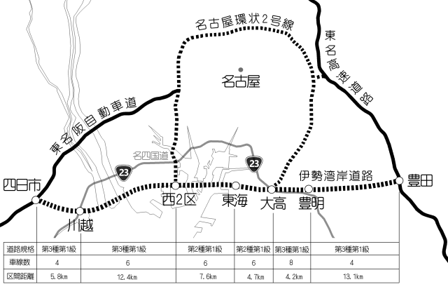
日本語: 1980年代の伊勢湾岸道路計画図。典拠:『二十年のあゆみ』建設省中部地方建設局名四国道工事事務所、1980年3月、286頁・『中日新聞』1987年7月21日朝刊、3頁 |
| Date | |
| Source | Own work |
| Author | Oka21000 |
| SVG development |

Licensing
edit
I, the copyright holder of this work, hereby publish it under the following license:
This file is licensed under the Creative Commons Attribution-Share Alike 4.0 International license.
- You are free:
- to share – to copy, distribute and transmit the work
- to remix – to adapt the work
- Under the following conditions:
- attribution – You must give appropriate credit, provide a link to the license, and indicate if changes were made. You may do so in any reasonable manner, but not in any way that suggests the licensor endorses you or your use.
- share alike – If you remix, transform, or build upon the material, you must distribute your contributions under the same or compatible license as the original.
File history
Click on a date/time to view the file as it appeared at that time.
| Date/Time | Thumbnail | Dimensions | User | Comment | |
|---|---|---|---|---|---|
| current | 07:18, 5 January 2020 | | 4,075 × 2,622 (652 KB) | Oka21000 (talk | contribs) | User created page with UploadWizard |
You cannot overwrite this file.
File usage on Commons
There are no pages that use this file.
File usage on other wikis
The following other wikis use this file:
- Usage on ja.wikipedia.org