File:John Gorton building, Canberra - perspective controlled.jpg

Size of this preview: 800 × 450 pixels. Other resolutions: 320 × 180 pixels | 640 × 360 pixels | 1,024 × 576 pixels | 1,280 × 720 pixels | 2,560 × 1,440 pixels | 6,494 × 3,653 pixels.
Original file (6,494 × 3,653 pixels, file size: 25.09 MB, MIME type: image/jpeg)
Captions
Captions
Add a one-line explanation of what this file represents
Summary
edit
| Description |
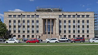
English: John Gorton (Department of the Environment) building, Canberra. Stitched with Hugin, perspective adjustment with Darktable. |
| Date | |
| Source | Own work |
| Author | Thennicke |
| Camera location | | View this and other nearby images on: OpenStreetMap |
|---|
Licensing
edit
I, the copyright holder of this work, hereby publish it under the following license:
This file is licensed under the Creative Commons Attribution-Share Alike 4.0 International license.
- You are free:
- to share – to copy, distribute and transmit the work
- to remix – to adapt the work
- Under the following conditions:
- attribution – You must give appropriate credit, provide a link to the license, and indicate if changes were made. You may do so in any reasonable manner, but not in any way that suggests the licensor endorses you or your use.
- share alike – If you remix, transform, or build upon the material, you must distribute your contributions under the same or compatible license as the original.
File history
Click on a date/time to view the file as it appeared at that time.
| Date/Time | Thumbnail | Dimensions | User | Comment | |
|---|---|---|---|---|---|
| current | 02:48, 28 March 2016 | | 6,494 × 3,653 (25.09 MB) | Thennicke (talk | contribs) | User created page with UploadWizard |
You cannot overwrite this file.
File usage on Commons
The following 3 pages use this file:
- User:Thennicke/Canberra
- Commons:Wiki Loves Monuments 2017 in Australia/List of Australian heritage sites/List of Australian heritage sites in Australian Capital Territory
- Commons:Wiki Loves Monuments 2019 in Australia/List of Australian heritage sites/List of Australian heritage sites on the Commonwealth Heritage List/1
File usage on other wikis
The following other wikis use this file:
- Usage on en.wikipedia.org
- Usage on www.wikidata.org