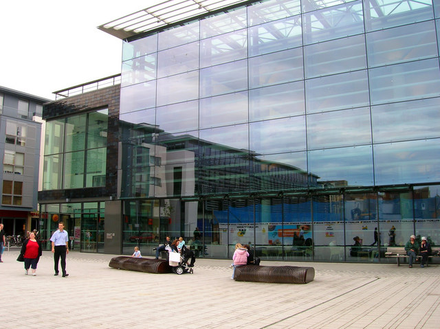
File:Jubilee Library, Jubilee Street - geograph.org.uk - 231185.jpg
Jubilee_Library,_Jubilee_Street_-_geograph.org.uk_-_231185.jpg (640 × 479 pixels, file size: 132 KB, MIME type: image/jpeg)
Captions
Captions
Summary edit
| DescriptionJubilee Library, Jubilee Street - geograph.org.uk - 231185.jpg |
English: Jubilee Library, Jubilee Street. Head south down North Place then follow the paths around the swimming pool and turn west into this new square. Something that won't be found on an OS Map is the city's new purpose built library that finally opened in 2005 and has been a big success ever since it moved back from a tower block a mile to the north of the centre. The library is part of the Jubilee Street development that has finally after 30 years of wrangling filled the space between Church Street and North Road that was an eyesore. The original Jubilee Street was filled with small houses and workshops that had been gradually cleared from the 1950s until the last buildings came down in 1977. The area then became a car park as the Council and developers argued what to do with the site. Finally an agreement was reached in 2001 and most of the street has been rebuilt with the exception of a site opposite the library which is earmarked for a hotel. There is some concern that the shops that have opened in the street (including a Tesco Express and Starbucks) are trying to muscle their way into the independent shopping experience of this area as by doing so they put the rents up for other shops. However, a quick glance reveals that Gardner Street which runs parallel with Jubilee Street is still more popular.
Click on the link to take you to the next page. https://www.geograph.org.uk/photo/231199 |
| Date | |
| Source | From geograph.org.uk |
| Author | Simon Carey |
| Attribution (required by the license) InfoField | Simon Carey / Jubilee Library, Jubilee Street / |
InfoField | Simon Carey / Jubilee Library, Jubilee Street |
| Camera location | 50° 49′ 29″ N, 0° 08′ 17″ W | View this and other nearby images on: OpenStreetMap |
|---|
| Object location | 50° 49′ 29″ N, 0° 08′ 17″ W | View this and other nearby images on: OpenStreetMap |
|---|
Licensing edit

|
This image was taken from the Geograph project collection. See this photograph's page on the Geograph website for the photographer's contact details. The copyright on this image is owned by Simon Carey and is licensed for reuse under the Creative Commons Attribution-ShareAlike 2.0 license.
|
- You are free:
- to share – to copy, distribute and transmit the work
- to remix – to adapt the work
- Under the following conditions:
- attribution – You must give appropriate credit, provide a link to the license, and indicate if changes were made. You may do so in any reasonable manner, but not in any way that suggests the licensor endorses you or your use.
- share alike – If you remix, transform, or build upon the material, you must distribute your contributions under the same or compatible license as the original.
- Remove redundant categories and try to put this image in the most specific category/categories
- Remove this template
- The location categories are based on information from this geonames tool and this OpenStreetMap tool combined with a database. You can also have a look at this tool from mysociety.
- The topic category from Geograph was Library (find similar images at Geograph)
English | suomi | français | galego | עברית | magyar | македонски | മലയാളം | português | português do Brasil | Türkçe | +/−
File history
Click on a date/time to view the file as it appeared at that time.
| Date/Time | Thumbnail | Dimensions | User | Comment | |
|---|---|---|---|---|---|
| current | 00:49, 1 February 2010 |  | 640 × 479 (132 KB) | GeographBot (talk | contribs) | == {{int:filedesc}} == {{Information |description={{en|1=Jubilee Library, Jubilee Street. Head south down North Place then follow the paths around the swimming pool and turn west into this new square. Something that won't be found on an OS Map is the city |
You cannot overwrite this file.
File usage on Commons
The following 2 pages use this file:
File usage on other wikis
The following other wikis use this file:
- Usage on en.wikipedia.org
Metadata
This file contains additional information such as Exif metadata which may have been added by the digital camera, scanner, or software program used to create or digitize it. If the file has been modified from its original state, some details such as the timestamp may not fully reflect those of the original file. The timestamp is only as accurate as the clock in the camera, and it may be completely wrong.
| Camera manufacturer | NIKON |
|---|---|
| Camera model | E4600 |
| Exposure time | 1/100 sec (0.01) |
| F-number | f/4.9 |
| ISO speed rating | 50 |
| Date and time of data generation | 11:54, 1 September 2006 |
| Lens focal length | 5.7 mm |
| Orientation | Normal |
| Horizontal resolution | 300 dpi |
| Vertical resolution | 300 dpi |
| Software used | PictureProject 1.1.0 M |
| File change date and time | 19:13, 1 September 2006 |
| Y and C positioning | Centered |
| Exposure Program | Normal program |
| Exif version | 2.2 |
| Date and time of digitizing | 11:54, 1 September 2006 |
| APEX exposure bias | 0 |
| Maximum land aperture | 3 APEX (f/2.83) |
| Metering mode | Pattern |
| Light source | Unknown |
| Flash | Flash did not fire, auto mode |
| Color space | sRGB |
