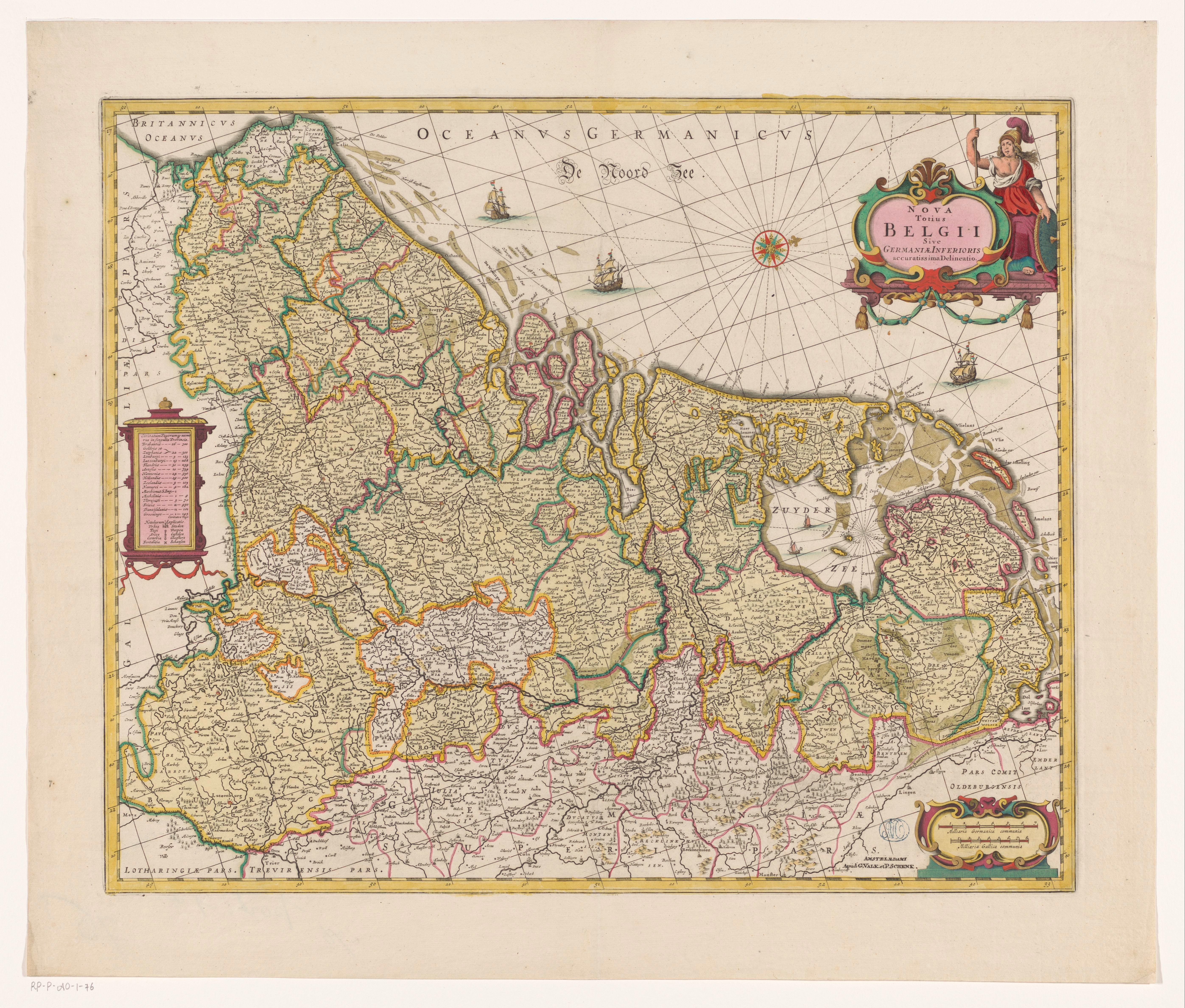
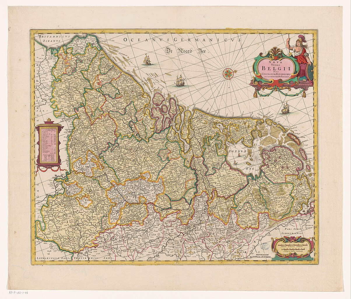
File:Kaart van de Zeventien Provinciën Nova totius Belgii sive Germaniae Inferioris accuratissima delineatio (titel op object), RP-P-AO-1-76.jpg
Size of this preview: 705 × 600 pixels. Other resolutions: 282 × 240 pixels | 564 × 480 pixels | 903 × 768 pixels | 1,204 × 1,024 pixels | 2,407 × 2,048 pixels | 5,588 × 4,754 pixels.
Original file (5,588 × 4,754 pixels, file size: 4.23 MB, MIME type: image/jpeg)
Captions
Captions
Add a one-line explanation of what this file represents
Summary
edit,_RP-P-AO-1-76.jpg&action=edit§ion=1)
| Description |
Nederlands: Identificatie Titel(s): Kaart van de Zeventien Provinciën. Nova totius Belgii sive Germaniae Inferioris accuratissima delineatio (titel op object) Objecttype: prent kaart Objectnummer: RP-P-AO-1-76 Catalogusreferentie: Van der Heijden 108-4(4) Opschriften / Merken: verzamelaarsmerk, recto rechtsonder, gestempeld: Lugt 195verzamelaarsmerk, verso, gestempeld: Lugt 2228 Omschrijving: Links een cartouche met een overzicht van de provincies, topografische informatie en een legenda. Rechtsboven titelcartouche, links daarvan staat Minerva afgebeeld. Rechtsonder schaalstok: Milliaria Germanica communia, Milliaria Gallica communia. Gradenverdeling langs de randen. Oriëntatie: noorden rechts. Op verso Latijnse tekst in boekdruk, titel: Germania Inferior sive Belgica hodierna. Vervaardiging Vervaardiger: prentmaker: anoniemuitgever: Gerard Valck (vermeld op object), uitgever: Pieter Schenk (I) (vermeld op object) Datering: 1638 en/of ca. 1700 Fysieke kenmerken: gravure, met de hand gekleurd Materiaal: papier Techniek: graveren (drukprocedé) / met de hand kleuren Afmetingen: plaatrand: h 443 mm × b 544 mm Onderwerp Wat: maps of separate countries or regions(story of) Minerva (Pallas, Athena) Waar: Nederlanden Verwerving en rechten Verwerving: overdracht van beheer 1887 Copyright: Publiek domein |
| Date | en/of ca. 1700 |
| Source | http://hdl.handle.net/10934/RM0001.COLLECT.605420 |
| Author | Rijksmuseum |
Licensing
edit,_RP-P-AO-1-76.jpg&action=edit§ion=2)
| This file is made available under the Creative Commons CC0 1.0 Universal Public Domain Dedication. | |
| The person who associated a work with this deed has dedicated the work to the public domain by waiving all of their rights to the work worldwide under copyright law, including all related and neighboring rights, to the extent allowed by law. You can copy, modify, distribute and perform the work, even for commercial purposes, all without asking permission.
|
File history
Click on a date/time to view the file as it appeared at that time.
| Date/Time | Thumbnail | Dimensions | User | Comment | |
|---|---|---|---|---|---|
| current | 15:40, 6 December 2019 | | 5,588 × 4,754 (4.23 MB) | Mr.Nostalgic (talk | contribs) | == {{int:filedesc}} == {{Information |Description={{nl|1=<br><br><big>'''Identificatie'''</big><br>'''Titel(s): '''Kaart van de Zeventien ProvinciënNova totius Belgii sive Germaniae Inferioris accuratissima delineatio (titel op object)<br>'''Objecttype:''' prent kaart <br>'''Objectnummer:''' RP-P-AO-1-76<br>'''Catalogusreferentie:''' Van der Heijden 108-4(4)<br>'''Opschriften / Merken:''' verzamelaarsmerk, recto rechtsonder, gestempeld: Lugt 195verzamelaarsmerk, verso, gestempeld: Lugt 2228<b... |
You cannot overwrite this file.
File usage on Commons
There are no pages that use this file.
,_RP-P-AO-1-76.jpg&oldid=842385778)