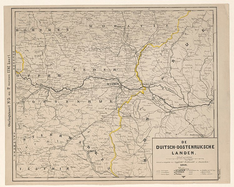
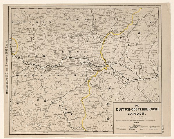
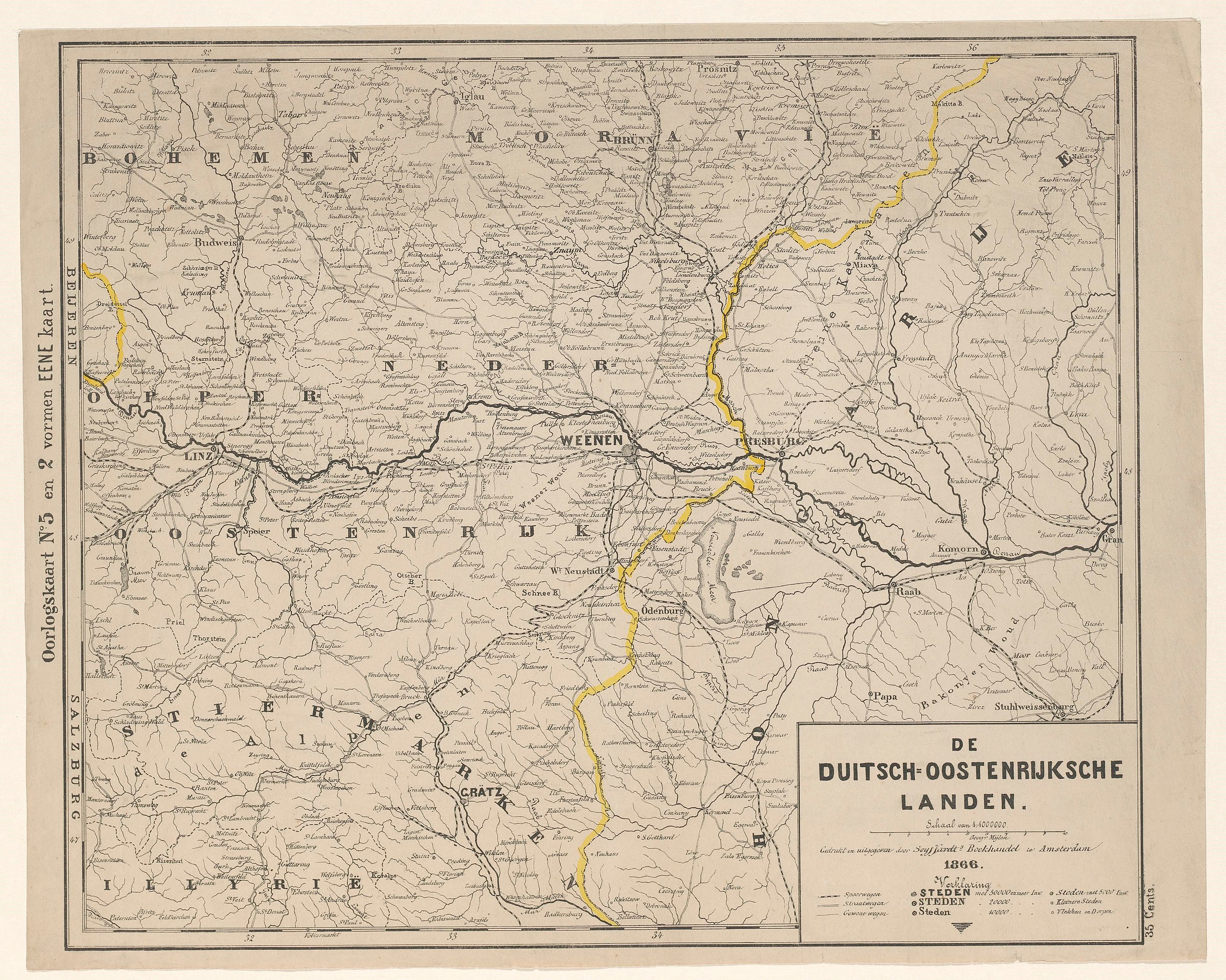
File:Kaart van het grensgebied van Oostenrijk en Hongarije De Duitsch-Oostenrijksche landen (titel op object), RP-P-2018-1059.jpg

Size of this preview: 750 × 600 pixels. Other resolutions: 300 × 240 pixels | 600 × 480 pixels | 960 × 768 pixels | 1,280 × 1,024 pixels | 2,560 × 2,047 pixels | 3,836 × 3,068 pixels.
Original file (3,836 × 3,068 pixels, file size: 2.06 MB, MIME type: image/jpeg)
Captions
Captions
Add a one-line explanation of what this file represents
Summary
edit,_RP-P-2018-1059.jpg&action=edit§ion=1)
| Description |
Nederlands: Identificatie Titel(s): Kaart van het grensgebied van Oostenrijk en Hongarije. De Duitsch-Oostenrijksche landen (titel op object) Objecttype: prent kaart Objectnummer: RP-P-2018-1059 Vervaardiging Vervaardiger: prentmaker: anoniem, drukker: boekhandel te Amsterdam Seijffardt (vermeld op object), uitgever: boekhandel te Amsterdam Seijffardt (vermeld op object) Plaats vervaardiging: Amsterdam Datering: 1866 Materiaal: papier Techniek: kleurenlithografie (procedé) Afmetingen: blad: h 345 mm × b 433 mm Onderwerp Wat: maps of separate countries or regions. Oostenrijks-Pruisische Oorlog Wanneer: 1866 - 1866 Waar: Oostenrijk. Hongarije Verwerving en rechten Verwerving: onbekend 2018 Copyright: Publiek domein |
| Date | |
| Source | http://hdl.handle.net/10934/RM0001.COLLECT.705965 |
| Author | Rijksmuseum |
Licensing
edit,_RP-P-2018-1059.jpg&action=edit§ion=2)
| This file is made available under the Creative Commons CC0 1.0 Universal Public Domain Dedication. | |
| The person who associated a work with this deed has dedicated the work to the public domain by waiving all of their rights to the work worldwide under copyright law, including all related and neighboring rights, to the extent allowed by law. You can copy, modify, distribute and perform the work, even for commercial purposes, all without asking permission.
|
File history
Click on a date/time to view the file as it appeared at that time.
| Date/Time | Thumbnail | Dimensions | User | Comment | |
|---|---|---|---|---|---|
| current | 23:22, 1 January 2020 | | 3,836 × 3,068 (2.06 MB) | Mr.Nostalgic (talk | contribs) | == {{int:filedesc}} == {{Information |Description={{nl|1=<br><br><big>'''Identificatie'''</big><br>'''Titel(s): '''Kaart van het grensgebied van Oostenrijk en HongarijeDe Duitsch-Oostenrijksche landen (titel op object)<br>'''Objecttype:''' prent kaart <br>'''Objectnummer:''' RP-P-2018-1059<br><br><big>'''Vervaardiging'''</big><br>'''Vervaardiger:''' prentmaker: anoniemdrukker: boekhandel te Amsterdam Seijffardt (vermeld op object)uitgever: boekhandel te Amsterdam Seijffardt (vermeld op object... |
You cannot overwrite this file.
File usage on Commons
There are no pages that use this file.
,_RP-P-2018-1059.jpg&oldid=841963887)