File:Kalmuckisk karta över Dzungariet m fl områden (Renat 1-A).jpg

Original file (1,000 × 792 pixels, file size: 324 KB, MIME type: image/jpeg)
Captions
Captions
Summary
edit.jpg&action=edit§ion=1)
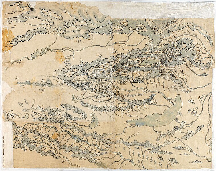
| Description |
日本語: スウェーデン軍曹レナート (1682-1744) により1734年に母国スウェーデンに伝えられた、ジューン・ガル製とされる中央アジア地図。 |
| Date | |
| Source | https://goran.baarnhielm.net/Kartor/Rysslandskartor/Rysslandskartor.htm |
| Author | Johan Gustaf Renat |
Uppsala University Library
Licensing
edit.jpg&action=edit§ion=2)
|
This work is in the public domain in its country of origin and other countries and areas where the copyright term is the author's life plus 70 years or fewer.
| |
| This file has been identified as being free of known restrictions under copyright law, including all related and neighboring rights. | |

|
This media file is uncategorized.
Please help improve this media file by adding it to one or more categories, so it may be associated with related media files (how?), and so that it can be more easily found.
Please notify the uploader with {{subst:Please link images|File:Kalmuckisk karta över Dzungariet m fl områden (Renat 1-A).jpg}} ~~~~ |
| Annotations | This image is annotated: View the annotations at Commons |
.jpg)
File history
Click on a date/time to view the file as it appeared at that time.
| Date/Time | Thumbnail | Dimensions | User | Comment | |
|---|---|---|---|---|---|
| current | 03:49, 18 February 2024 | | 1,000 × 792 (324 KB) | SteinsplitterBot (talk | contribs) | Bot: Image rotated by 180° |
| 15:22, 16 February 2024 |  | 1,000 × 796 (318 KB) | SKM T KHR (talk | contribs) | Uploaded a work by Johan Gustaf Renat from https://goran.baarnhielm.net/Kartor/Rysslandskartor/Rysslandskartor.htm with UploadWizard |
You cannot overwrite this file.
File usage on Commons
There are no pages that use this file.
File usage on other wikis
The following other wikis use this file:
- Usage on ja.wikipedia.org
.jpg&oldid=853035411)