File:Kjerkfjorden Moskenesoeya.jpg

Size of this preview: 800 × 600 pixels. Other resolutions: 320 × 240 pixels | 640 × 480 pixels | 1,024 × 768 pixels.
Original file (1,024 × 768 pixels, file size: 293 KB, MIME type: image/jpeg)
Captions
Captions
Add a one-line explanation of what this file represents
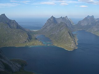
| Description | Moskenesøya: Kjerkfjorden til høgre, Bunesfjorden i midten, Forsfjorden går mot venstre. Bygdelaget på neset til venstre for Bunesfjorden heiter Vindnes, medan bygda Kjerkfjorden ligg inst i Kjerkfjorden. Fjelltoppen til venstre er Storskiva (848 moh.). Den høgaste av toppane på høgre side av Bunesfjorden er Stamprevtinden (748 moh.), medan Breiflogtinden er 720 moh. og Moltbærtinden er 700 moh. | ||
| Date | |||
| Source | originally posted to Flickr as CIMG2171 | ||
| Author | Leif | ||
| Permission (Reusing this file) |
This file is licensed under the Creative Commons Attribution 2.0 Generic license.
|
File history
Click on a date/time to view the file as it appeared at that time.
| Date/Time | Thumbnail | Dimensions | User | Comment | |
|---|---|---|---|---|---|
| current | 18:06, 28 April 2009 | | 1,024 × 768 (293 KB) | Jorunn (talk | contribs) | {{Information |Description = Moskenesøya: Kjerkfjorden til høgre, Bunesfjorden i midten, Forsfjorden går mot venstre. Bygdelaget på neset til venstre for Bunesfjorden heiter Vindnes, medan bygda Kjerkfjorden ligg inst i Kjerkfjorden. Fjelltoppen til v |
You cannot overwrite this file.
File usage on Commons
There are no pages that use this file.
File usage on other wikis
The following other wikis use this file:
- Usage on cs.wikipedia.org
- Usage on da.wikipedia.org
- Usage on en.wikipedia.org
- Usage on fr.wikipedia.org
- Usage on nn.wikipedia.org
- Usage on no.wikipedia.org