File:Lage des Landkreises Ahrweiler in Deutschland.PNG
No higher resolution available.
Lage_des_Landkreises_Ahrweiler_in_Deutschland.PNG (197 × 235 pixels, file size: 2 KB, MIME type: image/png)
Captions
Captions
Add a one-line explanation of what this file represents
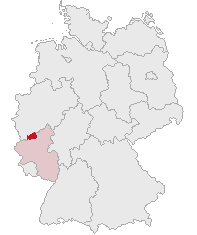
| Description | Landkreis Ahrweiler, Rhineland-Palatinate, Germany | ||||||||
| Date | |||||||||
| Source | Own work | ||||||||
| Author | own work by Geograv | ||||||||
| Permission (Reusing this file) |
|

File history
Click on a date/time to view the file as it appeared at that time.
| Date/Time | Thumbnail | Dimensions | User | Comment | |
|---|---|---|---|---|---|
| current | 22:05, 5 June 2007 | | 197 × 235 (2 KB) | Rauenstein (talk | contribs) | {{Information |Description=Landkreis Ahrweiler, Rhineland-Palatinate, Germany |Source=self |Date=2007-06-06 |Author=own work by Geograv |Permission= {{GFDL}} }} [[Category:Locator maps of districts in |
You cannot overwrite this file.
File usage on Commons
The following page uses this file:
File usage on other wikis
The following other wikis use this file:
- Usage on eo.wikipedia.org
- Usage on fr.wikipedia.org
- Usage on fy.wikipedia.org
- Usage on it.wikipedia.org
- Usage on ka.wikipedia.org
- Usage on kk.wikipedia.org
- Usage on pl.wikipedia.org
- Usage on sh.wikipedia.org
- Usage on sr.wikipedia.org
- Usage on sv.wikipedia.org
- Usage on tr.wikipedia.org