File:Liechtenstein administrative map-fr.svg

Size of this PNG preview of this SVG file: 459 × 599 pixels. Other resolutions: 184 × 240 pixels | 368 × 480 pixels | 589 × 768 pixels | 785 × 1,024 pixels | 1,570 × 2,048 pixels | 1,301 × 1,697 pixels.
Original file (SVG file, nominally 1,301 × 1,697 pixels, file size: 505 KB)
Captions
Captions
Add a one-line explanation of what this file represents
Summary edit
| Description |
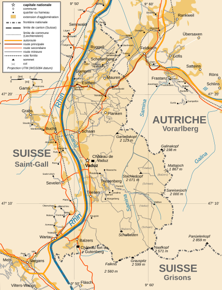
Français : Carte administrative en français du Liechtenstein Deutsch: Karte von Liechtenstein, französische Version English: Administrative map in French of Liechtenstein |
| Date | |
| Source |
Français : Création personnelle ; avec Inkscape ; projection UTM ; WGS84 datum ; Références utilisées pour les données complémentaires : * Rivières, villes, chemins de fers, routes : Demis add-on for World Wind (cf. l'e-mail d'approbation de Demis et le Demis forum) ; * Frontières et côtes : World data bank II + File:Liechtenstein-admin.png de user:Aotearoa English: Own work ; vectorized with Inkscape ; UTM projection ; WGS84 datum ; Reference used for the additional data : * Rivers, cities, railroads, routes : Demis add-on for World Wind (see the approval e-mail and the Demis forum) ; * Borders and coast : World data bank II + File:Liechtenstein-admin.png by user:Aotearoa Approximate geographic limits of the map (30" close) : * SW corner : 47°02'05"N – 9°40'00"E * SE corner : 47°02'05"N – 9°70'00"E * NE corner : 47°27'55"N – 9°70'00"E * NW corner : 47°27'55"N – 9°40'00"E |
| Author | Bourrichon - fr:Bourrichon |
| Permission (Reusing this file) |
GFDL / Attribution and Share-Alike required |
| Other versions |
|


|
This SVG file contains embedded text that can be translated into your language, using any capable SVG editor, text editor or the SVG Translate tool. For more information see: About translating SVG files. |
Licensing edit
I, the copyright holder of this work, hereby publish it under the following licenses:

|
Permission is granted to copy, distribute and/or modify this document under the terms of the GNU Free Documentation License, Version 1.2 or any later version published by the Free Software Foundation; with no Invariant Sections, no Front-Cover Texts, and no Back-Cover Texts. A copy of the license is included in the section entitled GNU Free Documentation License. |
This file is licensed under the Creative Commons Attribution-Share Alike 4.0 International, 3.0 Unported, 2.5 Generic, 2.0 Generic and 1.0 Generic license.
- You are free:
- to share – to copy, distribute and transmit the work
- to remix – to adapt the work
- Under the following conditions:
- attribution – You must give appropriate credit, provide a link to the license, and indicate if changes were made. You may do so in any reasonable manner, but not in any way that suggests the licensor endorses you or your use.
- share alike – If you remix, transform, or build upon the material, you must distribute your contributions under the same or compatible license as the original.
You may select the license of your choice.
File history
Click on a date/time to view the file as it appeared at that time.
| Date/Time | Thumbnail | Dimensions | User | Comment | |
|---|---|---|---|---|---|
| current | 16:49, 15 January 2010 | | 1,301 × 1,697 (505 KB) | Bourrichon (talk | contribs) | corrections |
| 20:22, 30 October 2009 |  | 1,301 × 1,697 (503 KB) | Koryakov Yuri (talk | contribs) | Reverted to version as of 18:42, 13 March 2009 | |
| 20:21, 30 October 2009 |  | 1,301 × 1,697 (524 KB) | Koryakov Yuri (talk | contribs) | Added many villages | |
| 18:42, 13 March 2009 |  | 1,301 × 1,697 (503 KB) | Bourrichon (talk | contribs) | == Summary == {{Information |Description={{fr|Carte administrative en français du Liechtenstein}}{{de|Karte von Liechtenstein, französische Version}}{{en|Administrative map in French of [[:en:Liechtenstein|Lie |
You cannot overwrite this file.
File usage on Commons
The following 11 pages use this file:
- Atlas of Liechtenstein
- File:Liechtenstein administrative map-ru.svg
- File:Liechtenstein administrative map-uk.svg
- File:Liechtenstein topographic map-de.png
- File:Liechtenstein topographic map-de.svg
- File:Liechtenstein topographic map-de Version Tschubby.png
- File:Liechtenstein topographic map-fr.png
- File:Liechtenstein topographic map-fr.svg
- File:Liechtenstein topographic map-mk.svg
- File:Liechtenstein topographic map-ru.svg
- Category:Stamps of Liechtenstein
File usage on other wikis
The following other wikis use this file:
- Usage on de.wikipedia.org
- Usage on en.wikipedia.org
- Usage on fr.wikipedia.org
- Usage on rm.wikipedia.org
- Usage on ru.wikipedia.org