File:List of countries gained independence from the UK Flag version 3.svg

Size of this PNG preview of this SVG file: 800 × 396 pixels. Other resolutions: 320 × 159 pixels | 640 × 317 pixels | 1,024 × 507 pixels | 1,280 × 634 pixels | 2,560 × 1,268 pixels | 2,400 × 1,189 pixels.
Original file (SVG file, nominally 2,400 × 1,189 pixels, file size: 364 KB)
Captions
Captions
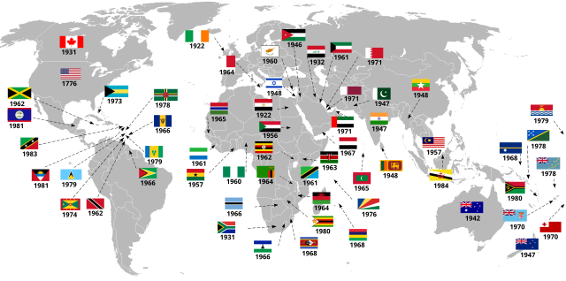
World map of of countries that have gained independence from the United Kingdom. Flags edition
Summary edit
| Description |
Cymraeg: Map o'r byd, gan ddangos y gwledydd hynny sydd wedi torri'n rhydd oddi wrth y 'Deyrnas Unedig'. Fersiwn baneri, di-iaith.
Addaswyd o - https://commons.wikimedia.org/wiki/File:Annibyniaeth_gwledydd_4.svg created in the Welsh language. Data: [1] Map: File:BlankMap-World-large-limited-recognition.png Baneri: National insignia, ar Comin.English: World map of of countries that have gained independence from the United Kingdom. Flags edition.
Translation of - https://commons.wikimedia.org/wiki/File:Annibyniaeth_gwledydd_4.svg created in the Welsh language. Source of data: [2] Source of map: File:BlankMap-World-large-limited-recognition.png Flags: National insignia, on Wiki Commons. |
| Date | |
| Source | Own work |
| Author | Llywelyn2000 |
| Other versions |
|


Licensing edit
I, the copyright holder of this work, hereby publish it under the following license:
This file is licensed under the Creative Commons Attribution-Share Alike 4.0 International license.
- You are free:
- to share – to copy, distribute and transmit the work
- to remix – to adapt the work
- Under the following conditions:
- attribution – You must give appropriate credit, provide a link to the license, and indicate if changes were made. You may do so in any reasonable manner, but not in any way that suggests the licensor endorses you or your use.
- share alike – If you remix, transform, or build upon the material, you must distribute your contributions under the same or compatible license as the original.
File history
Click on a date/time to view the file as it appeared at that time.
| Date/Time | Thumbnail | Dimensions | User | Comment | |
|---|---|---|---|---|---|
| current | 18:42, 16 July 2021 | | 2,400 × 1,189 (364 KB) | Goran tek-en (talk | contribs) | Edits requested by Snow Lion Fenian |
| 18:50, 4 July 2018 |  | 2,389 × 1,189 (362 KB) | Kobukson (talk | contribs) | Reverted to version as of 07:08, 6 November 2017 (UTC). Last change to this file was controversial/contested changes that broadened the definition of "gained independence" in order to serve user's agenda as shown by countries like South Korea (never ruled by UK) now being marked on the map. | |
| 12:35, 11 June 2018 |  | 2,389 × 1,189 (560 KB) | Glide08 (talk | contribs) | If Papua New Guinea and Nauru, which only gained independence from Australia, are included, all other countries which gained independence from a country that gained its independence from the UK must be, too. So I added them all. I also corrected some arrow placements, as well as the Dominican flag and the year for St Vincent independence, and backdated Zimbabwe's independence to the date of the Rhodesian UDI. | |
| 07:08, 6 November 2017 |  | 2,389 × 1,189 (362 KB) | Llywelyn2000 (talk | contribs) | Changed Cyprus date from 1961 to 1960 and moved location of Malaysia to the West. | |
| 17:18, 24 March 2017 |  | 2,389 × 1,189 (362 KB) | Llywelyn2000 (talk | contribs) | Woop. Cyprus flag! | |
| 17:13, 24 March 2017 |  | 2,389 × 1,189 (364 KB) | Llywelyn2000 (talk | contribs) | Changed the Cyprus flag to the one accepted by both sides; also changed 1964 to 1960 as per https://en.wikipedia.org/wiki/Flag_of_Cyprus - year of independence. | |
| 00:37, 15 March 2017 |  | 2,389 × 1,189 (359 KB) | Llywelyn2000 (talk | contribs) | Ireland to 1922 constitution Barbados to 1966 as per Infobox Australia to 1942 (Statute of Westminster Adoption) New Zeland to 1947(Statute of Westminster adopted) | |
| 12:53, 3 October 2015 |  | 2,389 × 1,189 (359 KB) | Llywelyn2000 (talk | contribs) | User created page with UploadWizard |
You cannot overwrite this file.
File usage on Commons
The following 4 pages use this file:
File usage on other wikis
The following other wikis use this file:
- Usage on ca.wikipedia.org
- Usage on en.wikipedia.org
- List of countries that have gained independence from the United Kingdom
- Wikipedia:Graphics Lab/Map workshop/Archive/Feb 2018
- Wikipedia:Graphics Lab/Map workshop/Archive/Sep 2018
- Wikipedia:Graphics Lab/Map workshop/Archive/Sep 2020
- Wikipedia:Graphics Lab/Map workshop/Archive/Dec 2020
- Wikipedia:Graphics Lab/Map workshop/Archive/Jun 2021
- Usage on et.wikipedia.org
- Usage on fa.wikipedia.org
- Usage on id.wikipedia.org
- Usage on tr.wikipedia.org
- Usage on ur.wikipedia.org
- Usage on zh.wikipedia.org