File:Liverpool Pioneers Park 354.jpg

Original file (4,032 × 3,024 pixels, file size: 5.37 MB, MIME type: image/jpeg)
Captions
Captions
Summary
edit
| Description |
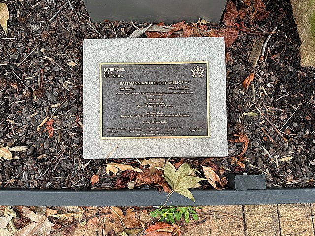
English: Liverpool Pioneers' Memorial Park, opened in 1821, is the second cemetery to be established in Liverpool, New South Wales. The cemetery was divided into denominational sectors from 1827, with Anglicans buried in an area closest to Campbell Street, Roman Catholics buried in an area running along Macquarie Street and a smaller area also running along Macquarie Street for Weslyeans. In 1884, a small area in the north-east corner of the site, adjacent to the Hume Highway was dedicated for Presbyterians plus an extension west of that (adjacent to Northumberland Street) for Catholic paupers burials.
There are many unmarked graves in the Northern sector of the park, which were allocated for the deceased from the local Asylum for Infirm and Destitute Men. The north-eastern corner of the cemetery was allocated to Presbyterians, the northwestern corner to Roman Catholic paupers, and the remainder to paupers of no known faith. 40 Armed Sevicemen are buried at the cemetery, however most of the official memorials were moved in 1962 to the NSW Garden of Remembrance at Rookwood Cemetery by the Australian War Graves Commission. Also of note was that 72 World War I German internees of Holsworthy Military Camp were buried in the cemetery, however in 1962 — at the request of the German government — their bodies were disinterred and moved to a memorial cemetery at Tatura, Victoria that commemorates all deceased German internees. The site has been closed for burials since 1958 and is now a rest park after legislation was passed (the Old Liverpool Cemetery Act). The park was reopened on 3 September 2010 by Mayor Wendy Waller. |
| Date | |
| Source | Own work |
| Author | Chris.sherlock2 |
| Camera location | | View this and other nearby images on: OpenStreetMap |
|---|
Licensing
edit
- You are free:
- to share – to copy, distribute and transmit the work
- to remix – to adapt the work
- Under the following conditions:
- attribution – You must give appropriate credit, provide a link to the license, and indicate if changes were made. You may do so in any reasonable manner, but not in any way that suggests the licensor endorses you or your use.
- share alike – If you remix, transform, or build upon the material, you must distribute your contributions under the same or compatible license as the original.
File history
Click on a date/time to view the file as it appeared at that time.
| Date/Time | Thumbnail | Dimensions | User | Comment | |
|---|---|---|---|---|---|
| current | 15:30, 12 February 2023 | | 4,032 × 3,024 (5.37 MB) | SteinsplitterBot (talk | contribs) | Bot: Image rotated by 270° |
| 11:39, 9 February 2023 |  | 3,024 × 4,032 (5.38 MB) | Chris.sherlock2 (talk | contribs) | Uploaded own work with UploadWizard |
You cannot overwrite this file.
File usage on Commons
There are no pages that use this file.