File:Lombard state 526.png

Size of this preview: 800 × 571 pixels. Other resolutions: 320 × 228 pixels | 640 × 457 pixels | 986 × 704 pixels.
Original file (986 × 704 pixels, file size: 51 KB, MIME type: image/png)
Captions
Captions
Add a one-line explanation of what this file represents
Summary
edit
| Description |
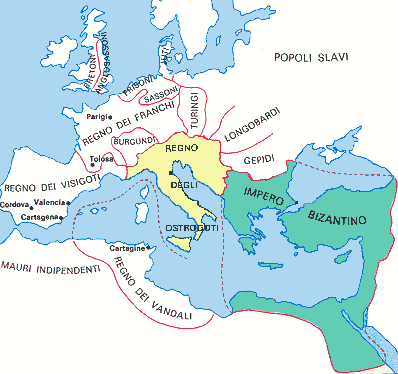
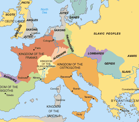
English: State of the Lombards in 526 AD. |
| Date | |
| Source | Own work - based on: Stjepan Srkulj, Hrvatska povijest u devetnaest karata, Zagreb, 1937. (online version of map from this book: [1]) |
| Author | PANONIAN |
| Other versions | Derivative works of this file: Lombard state 526.svg |
![[1]](http://www.dodaj.rs/f/3D/1D/4ZBxWIDO/teodvel.jpg)
Licensing
edit
I, the copyright holder of this work, hereby publish it under the following license:
| This file is made available under the Creative Commons CC0 1.0 Universal Public Domain Dedication. | |
| The person who associated a work with this deed has dedicated the work to the public domain by waiving all of their rights to the work worldwide under copyright law, including all related and neighboring rights, to the extent allowed by law. You can copy, modify, distribute and perform the work, even for commercial purposes, all without asking permission.
|
References
edit
6th century borders are drawn in accordance with this source map:
- [2], [3] (Source map originating from this book: Stjepan Srkulj, Hrvatska povijest u devetnaest karata, Zagreb, 1937. [4])
![[2]](https://marinknezovic.files.wordpress.com/2016/10/teodvel.jpg)
References for modern borders and cities:
- http://www.lib.utexas.edu/maps/europe/slovakia_map.jpg
- http://www.lib.utexas.edu/maps/europe/romania_pol96.jpg
Other secondary references:
- Denis Šehić - Demir Šehić, Istorijski atlas sveta, Beograd, 2007.
- Istorijski atlas, Intersistem kartografija, Beograd, 2010.
- The Times History of Europe, Times Books, London, 2002.
- Dragan Brujić, Vodič kroz svet Vizantije, Beograd, 2004.
- Školski istorijski atlas, Zavod za izdavanje udžbenika SR Srbije, Beograd, 1970.
- http://rbedrosian.com/Maps/muhamm6b.jpg
- http://www.fordham.edu/halsall/maps/526eur.jpg
- http://www.euratlas.net/history/europe/500/index.html
- http://www.homolaicus.com/arte/ravenna/map3.gif
- http://www.worldmapsonline.com/UnivHist/30305_6.gif
- http://www.globalsecurity.org/military/world/europe/images/byz-map-526.jpg
- http://manofroma.files.wordpress.com/2010/05/barbarian-europe.gif?w=454&h=399
- Muir's Historical Atlas - Medieval and Modern (London, 1911) - File:Europe in 526.jpg
File history
Click on a date/time to view the file as it appeared at that time.
| Date/Time | Thumbnail | Dimensions | User | Comment | |
|---|---|---|---|---|---|
| current | 19:08, 20 October 2011 | | 986 × 704 (51 KB) | PANONIAN (talk | contribs) | {{Information |Description ={{en|1=State of the Lombards in 526 AD.}} |Source ={{own}} |Author =PANONIAN |Date =2011 |Permission = |other_versions = }} |
You cannot overwrite this file.
File usage on Commons
There are no pages that use this file.
File usage on other wikis
The following other wikis use this file:
- Usage on af.wikipedia.org
- Usage on an.wikipedia.org
- Usage on ar.wikipedia.org
- Usage on de.wikipedia.org
- Usage on gl.wikipedia.org
- Usage on ja.wikipedia.org
- Usage on nl.wikipedia.org
- Usage on sh.wikipedia.org
- Usage on sr.wikipedia.org
- Usage on zh.wikipedia.org