File:London airport links map.png

Size of this preview: 800 × 559 pixels. Other resolutions: 320 × 224 pixels | 640 × 447 pixels | 1,024 × 716 pixels | 1,280 × 895 pixels | 1,592 × 1,113 pixels.
Original file (1,592 × 1,113 pixels, file size: 237 KB, MIME type: image/png)
Captions
Captions
Add a one-line explanation of what this file represents
Summary edit
| Description |
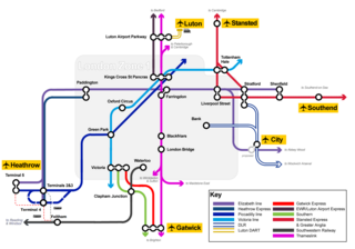
English: Diagrammatic map of the principal National Rail and London Underground lines which serve the airports around London. |
| Date | |
| Source | Own work |
| Author | Cnbrb |

|
This transport map image could be re-created using vector graphics as an SVG file. This has several advantages; see Commons:Media for cleanup for more information. If an SVG form of this image is available, please upload it and afterwards replace this template with
{{vector version available|new image name}}.
It is recommended to name the SVG file “London airport links map.svg”—then the template Vector version available (or Vva) does not need the new image name parameter. |
Licensing edit
I, the copyright holder of this work, hereby publish it under the following licenses:
This file is licensed under the Creative Commons Attribution-Share Alike 3.0 Unported license.
- You are free:
- to share – to copy, distribute and transmit the work
- to remix – to adapt the work
- Under the following conditions:
- attribution – You must give appropriate credit, provide a link to the license, and indicate if changes were made. You may do so in any reasonable manner, but not in any way that suggests the licensor endorses you or your use.
- share alike – If you remix, transform, or build upon the material, you must distribute your contributions under the same or compatible license as the original.

|
Permission is granted to copy, distribute and/or modify this document under the terms of the GNU Free Documentation License, Version 1.2 or any later version published by the Free Software Foundation; with no Invariant Sections, no Front-Cover Texts, and no Back-Cover Texts. A copy of the license is included in the section entitled GNU Free Documentation License. |
You may select the license of your choice.
File history
Click on a date/time to view the file as it appeared at that time.
| Date/Time | Thumbnail | Dimensions | User | Comment | |
|---|---|---|---|---|---|
| current | 11:43, 26 February 2024 | | 1,592 × 1,113 (237 KB) | J.M.Domingo (talk | contribs) | Blackfriars and London Bridge relative locations corrected |
| 21:57, 2 April 2023 |  | 1,592 × 1,113 (309 KB) | Cnbrb (talk | contribs) | add Luton Airport Express; DART colour | |
| 15:56, 12 March 2023 |  | 1,497 × 1,113 (296 KB) | Cnbrb (talk | contribs) | Luton DART now running | |
| 23:12, 30 October 2022 |  | 1,497 × 1,113 (222 KB) | Sunil060902 (talk | contribs) | Blackfriars and London Bridge relative locations corrected | |
| 09:54, 30 June 2022 |  | 1,497 × 1,113 (291 KB) | Cnbrb (talk | contribs) | add labels, tidy lines | |
| 23:37, 20 June 2022 |  | 1,497 × 1,113 (277 KB) | Cnbrb (talk | contribs) | Elizabeth line now represented as open | |
| 07:58, 17 May 2019 |  | 1,497 × 1,113 (275 KB) | Cnbrb (talk | contribs) | more wee tweaks | |
| 18:56, 16 May 2019 |  | 1,497 × 1,113 (277 KB) | Cnbrb (talk | contribs) | corrected Shenfield/Southend link | |
| 16:14, 16 September 2018 |  | 1,497 × 1,113 (279 KB) | Cnbrb (talk | contribs) | add Gatwick Express to Key | |
| 16:10, 16 September 2018 |  | 1,497 × 1,113 (278 KB) | Cnbrb (talk | contribs) | DLR to Stratford, add Southwestern Trains to key |
You cannot overwrite this file.
File usage on Commons
The following 39 pages use this file:
- Airports of London
- London Heathrow Airport
- Public transport in London
- Top 200 transport map images that should use vector graphics
- User:Chumwa/OgreBot/Potential transport maps/2018 September 11-20
- User:Chumwa/OgreBot/Potential transport maps/2019 May 11-20
- User:Chumwa/OgreBot/Public transport information/2018 September 11-20
- User:Chumwa/OgreBot/Public transport information/2019 May 11-20
- User:Chumwa/OgreBot/Public transport information/2022 June 11-20
- User:Chumwa/OgreBot/Public transport information/2022 June 21-30
- User:Chumwa/OgreBot/Public transport information/2022 October 21-31
- User:Chumwa/OgreBot/Public transport information/2023 March 11-20
- User:Chumwa/OgreBot/Public transport information/2024 February 20-29
- User:Chumwa/OgreBot/Transport Maps/2018 September 11-20
- User:Chumwa/OgreBot/Transport Maps/2019 May 11-20
- User:Chumwa/OgreBot/Transport Maps/2022 June 11-20
- User:Chumwa/OgreBot/Transport Maps/2022 June 21-30
- User:Chumwa/OgreBot/Transport Maps/2022 October 21-31
- User:Chumwa/OgreBot/Transport Maps/2023 March 11-20
- User:Chumwa/OgreBot/Transport Maps/2024 February 20-29
- User:Chumwa/OgreBot/Travel and communication maps/2018 September 11-20
- User:Chumwa/OgreBot/Travel and communication maps/2019 May 11-20
- User:Mattbuck/Railways/2018 September
- User:Mattbuck/Railways/2019 May
- User:Mattbuck/Railways/2022 June
- User:Mattbuck/Railways/2022 October
- User:Mattbuck/Railways/2023 March
- User:Mattbuck/Railways/2024 February
- User:Nordlicht8/Rail Germany/2018 September 11-20
- User:Nordlicht8/Rail Germany/2019 May 11-20
- User:Nordlicht8/Rail Germany/2022 June 11-20
- User:Nordlicht8/Rail Germany/2022 June 21-30
- User:Nordlicht8/Rail Germany/2022 October 21-31
- User:Nordlicht8/Rail Germany/2023 March 11-20
- User:Nordlicht8/Rail Germany/2024 February 20-29
- Commons:WikiProject Aviation/recent uploads/2018 September 15
- Commons:WikiProject Aviation/recent uploads/2018 September 16
- Commons:WikiProject Aviation/recent uploads/2019 May 16
- Commons:WikiProject Aviation/recent uploads/2019 May 17
File usage on other wikis
The following other wikis use this file:
- Usage on bn.wikipedia.org
- Usage on de.wikivoyage.org
- Usage on en.wikipedia.org
- Usage on en.wikivoyage.org
- Usage on es.wikipedia.org
- Usage on fr.wikivoyage.org
- Usage on incubator.wikimedia.org
- Usage on it.wikipedia.org
- Usage on it.wikivoyage.org
- Usage on ja.wikipedia.org
- Usage on lt.wikipedia.org
- Usage on nl.wikivoyage.org
- Usage on pl.wikivoyage.org
- Usage on pt.wikivoyage.org