File:M central serbia02.png

Size of this preview: 578 × 600 pixels. Other resolutions: 231 × 240 pixels | 463 × 480 pixels | 850 × 882 pixels.
Original file (850 × 882 pixels, file size: 89 KB, MIME type: image/png)
Captions
Captions
Add a one-line explanation of what this file represents
Summary edit
| Description |
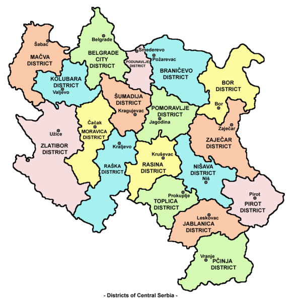
English: Map of districts in Central Serbia. Српски / srpski: Mapa okruga u Centralnoj Srbiji. |
| Date | 4 January 2007 (original upload date) |
| Source | Own work by the original uploader |
| Author | PANONIAN at English Wikipedia |
Licensing edit
| This work has been released into the public domain by its author, PANONIAN at English Wikipedia. This applies worldwide. In some countries this may not be legally possible; if so: PANONIAN grants anyone the right to use this work for any purpose, without any conditions, unless such conditions are required by law. |
References edit
- Denis Šehić - Demir Šehić, Geografski atlas Srbije, Beograd, 2007.
- Geografski atlas, Magic Map, Smederevska Palanka, 2001.
- Geografski atlas, Intersistem Kartografija, Beograd, 2004.
- http://www.infobih.com/slike/201009031054350.Srbija_okruzi3.PNG
- http://static.politika.co.rs/uploads/rubrike/141057/i/1/e07b01-radna-mesta-po-okruzima.gif[dead link]
- http://www.sandzaknews.com/slike/vijest-2681.jpg archive copy at the Wayback Machine
- http://www.arhiva.srbija.gov.rs/g/images/srbija.gif
- http://www.komisija1944.mpravde.gov.rs/imgs/mapa-srbije.png
Original upload log edit
Transferred from en.wikipedia to Commons by Mangostar using CommonsHelper.
The original description page was here. All following user names refer to en.wikipedia.
- 2007-01-04 17:00 PANONIAN 700×722×??? (297371 bytes) Map of Central Serbia (self-made) {{PD-self}} [[Category:Maps of Serbia]]
File history
Click on a date/time to view the file as it appeared at that time.
| Date/Time | Thumbnail | Dimensions | User | Comment | |
|---|---|---|---|---|---|
| current | 09:44, 22 January 2011 | | 850 × 882 (89 KB) | PANONIAN (talk | contribs) | improved version |
| 17:35, 23 August 2008 |  | 700 × 722 (290 KB) | File Upload Bot (Magnus Manske) (talk | contribs) | {{BotMoveToCommons|en.wikipedia}} {{Information |Description={{en|Map of Central Serbia (self-made) en:Category:Maps of Serbia}} |Source=Transferred from [http://en.wikipedia.org en.wikipedia]; transferred to Commons by User:Mangostar using [ht |
You cannot overwrite this file.
File usage on Commons
There are no pages that use this file.
File usage on other wikis
The following other wikis use this file:
- Usage on ca.wikipedia.org
- Usage on de.wikipedia.org
- Usage on en.wikipedia.org
- Usage on es.wikipedia.org
- Usage on eu.wikipedia.org
- Usage on fr.wikipedia.org
- Usage on gl.wikipedia.org
- Usage on he.wikipedia.org
- Usage on it.wikipedia.org
- Usage on ja.wikipedia.org
- Usage on ko.wikipedia.org
- Usage on nl.wikipedia.org
- Usage on pnb.wikipedia.org
- Usage on pt.wikipedia.org
- Usage on ro.wikipedia.org
- Usage on sv.wikipedia.org