File:Map8 eng trans.png

Size of this preview: 800 × 536 pixels. Other resolutions: 320 × 214 pixels | 640 × 428 pixels | 1,024 × 686 pixels | 1,280 × 857 pixels | 2,560 × 1,714 pixels | 4,000 × 2,678 pixels.
Original file (4,000 × 2,678 pixels, file size: 419 KB, MIME type: image/png)
Captions
Captions
Add a one-line explanation of what this file represents
Summary edit
| Description |
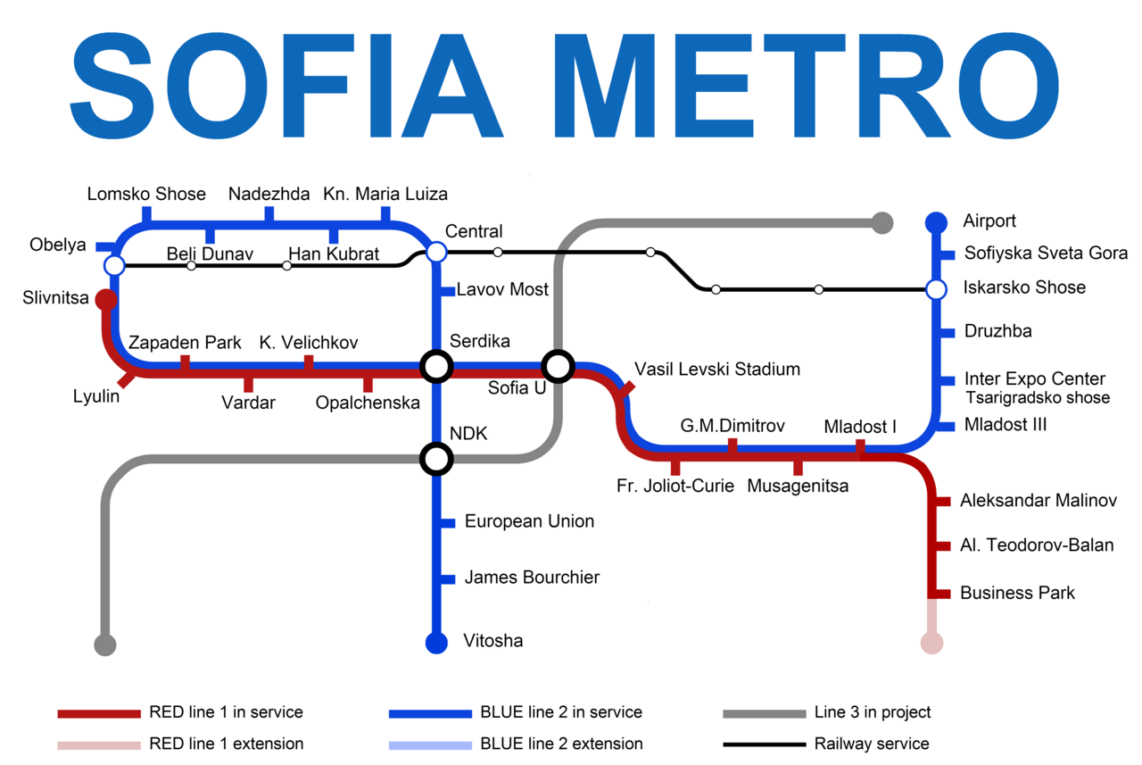
English: Sofia Metro map |
| Date | |
| Source | Own work |
| Author | Verminclone |
Licensing edit
I, the copyright holder of this work, hereby publish it under the following license:
This file is licensed under the Creative Commons Attribution-Share Alike 3.0 Unported license.
- You are free:
- to share – to copy, distribute and transmit the work
- to remix – to adapt the work
- Under the following conditions:
- attribution – You must give appropriate credit, provide a link to the license, and indicate if changes were made. You may do so in any reasonable manner, but not in any way that suggests the licensor endorses you or your use.
- share alike – If you remix, transform, or build upon the material, you must distribute your contributions under the same or compatible license as the original.
File history
Click on a date/time to view the file as it appeared at that time.
| Date/Time | Thumbnail | Dimensions | User | Comment | |
|---|---|---|---|---|---|
| current | 17:39, 20 July 2016 | | 4,000 × 2,678 (419 KB) | Skycycle (talk | contribs) | added Vitosha station, opened today (July 20, 2016) |
| 10:44, 10 May 2015 |  | 5,496 × 3,680 (464 KB) | Verminclone (talk | contribs) | Regular service update | |
| 00:14, 4 April 2015 |  | 5,496 × 3,680 (571 KB) | Verminclone (talk | contribs) | Final update | |
| 22:14, 3 April 2015 |  | 5,500 × 3,000 (663 KB) | Verminclone (talk | contribs) | Updated Service | |
| 22:12, 3 April 2015 |  | 5,327 × 2,281 (470 KB) | Verminclone (talk | contribs) | Reverted to version as of 22:05, 3 April 2015 | |
| 22:12, 3 April 2015 |  | 5,500 × 4,600 (896 KB) | Verminclone (talk | contribs) | Reverted to version as of 21:58, 3 April 2015 | |
| 22:05, 3 April 2015 |  | 5,327 × 2,281 (470 KB) | Secondarywaltz (talk | contribs) | trim the white space - again! | |
| 21:58, 3 April 2015 |  | 5,500 × 4,600 (896 KB) | Verminclone (talk | contribs) | Updated service | |
| 19:42, 25 December 2012 |  | 4,992 × 2,752 (305 KB) | Secondarywaltz (talk | contribs) | trim excess - full size | |
| 19:38, 25 December 2012 |  | 5,250 × 3,750 (647 KB) | Secondarywaltz (talk | contribs) | Good idea wrong size Reverted to version as of 10:07, 28 October 2012 |
You cannot overwrite this file.
File usage on Commons
The following 8 pages use this file:
- User:Chumwa/OgreBot/Potential transport maps/2016 July 11-20
- User:Chumwa/OgreBot/Public transport information/2015 April 1-10
- User:Chumwa/OgreBot/Public transport information/2015 May 1-10
- User:Chumwa/OgreBot/Public transport information/2016 July 11-20
- User:Chumwa/OgreBot/Transport Maps/2015 April 1-10
- User:Chumwa/OgreBot/Transport Maps/2015 May 1-10
- User:Chumwa/OgreBot/Transport Maps/2016 July 11-20
- User:Chumwa/OgreBot/Travel and communication maps/2016 July 11-20
File usage on other wikis
The following other wikis use this file:
- Usage on bn.wikipedia.org
- Usage on it.wikivoyage.org
- Usage on ja.wikipedia.org
- Usage on nl.wikipedia.org
- Usage on ru.wikivoyage.org