File:Map Hudson County NJ municipalities.gif
No higher resolution available.
Map_Hudson_County_NJ_municipalities.gif (430 × 599 pixels, file size: 25 KB, MIME type: image/gif)
Captions
Captions
Add a one-line explanation of what this file represents
Summary
edit

|
This locator map image could be re-created using vector graphics as an SVG file. This has several advantages; see Commons:Media for cleanup for more information. If an SVG form of this image is available, please upload it and afterwards replace this template with
{{vector version available|new image name}}.
It is recommended to name the SVG file “Map Hudson County NJ municipalities.svg”—then the template Vector version available (or Vva) does not need the new image name parameter. |
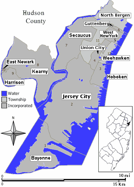
| Description | Closeup view of map of Hudson County, New Jersey (in style of map work by Jim Irwin, December 2005), with distance scale in miles/kilometers, Interstate-icons enlarged 50%, town names clarified, and side-edges limited (maximum width 430px < 600px helps readability). |
| Date | |
| Source |
Hand-edited like Wikimedia map: Image:Middletown twp nj 025.png (using gray town areas, with miles/kilometer scale, and road/icon colors). |
| Author | Wikid77 |
Licensing
edit
I, the copyright holder of this work, hereby publish it under the following license:
| This file is licensed under the Creative Commons Attribution-Share Alike 3.0 Unported license. Subject to disclaimers. | ||
| ||
| This licensing tag was added to this file as part of the GFDL licensing update. |

|
Permission is granted to copy, distribute and/or modify this document under the terms of the GNU Free Documentation License, Version 1.2 or any later version published by the Free Software Foundation; with no Invariant Sections, no Front-Cover Texts, and no Back-Cover Texts. A copy of the license is included in the section entitled GNU Free Documentation License. Subject to disclaimers. |
File history
Click on a date/time to view the file as it appeared at that time.
| Date/Time | Thumbnail | Dimensions | User | Comment | |
|---|---|---|---|---|---|
| current | 23:37, 21 August 2007 | | 430 × 599 (25 KB) | Wikid77 (talk | contribs) | added forgotten name "West New York" on area #5 |
| 23:19, 21 August 2007 |  | 430 × 599 (24 KB) | Wikid77 (talk | contribs) | redrew entire map with detailed water-boundaries (actually more narrow 430px), with darker town names | |
| 17:21, 21 August 2007 |  | 540 × 580 (21 KB) | Wikid77 (talk | contribs) | {{Information | Description= Closeup view of map of Hudson County, New Jersey (in style of map work by Jim Irwin, December 2005), with distance scale in miles/kilometers, Interstate-icons enlarged 50%, town names clarifie |
You cannot overwrite this file.
File usage on Commons
There are no pages that use this file.