File:Map from An history of Birmingham.jpg

Original file (4,323 × 3,214 pixels, file size: 2.91 MB, MIME type: image/jpeg)
Captions
Captions
| Title |
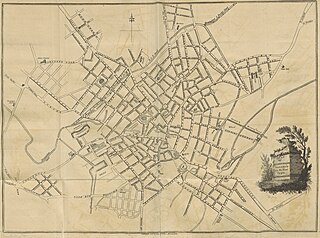
Map from 'An history of Birmingham' |
||||
| Description |
Map of Birmingham, England, surveyed 1795. Extracted from page 37 of An history of Birmingham ... With a new introduction by Christopher R. Erington.', by William Hutton. Original book held and digitised by the British Library. Copied from Flickr. Note: The colours, contrast and appearance of these illustrations are unlikely to be true to life. They are derived from scanned images that have been enhanced for machine interpretation and have been altered from their originals. |
||||
| Date | |||||
| Source |
|
||||
| Permission (Reusing this file) |
|
||||
| Geotemporal data | |||||
| Date depicted | |||||
| Georeferencing | |||||
| Archival data | |||||
| Collection | |||||
| Accession number |
British Library HMNTS 10360.dd.11. |
||||


File history
Click on a date/time to view the file as it appeared at that time.
| Date/Time | Thumbnail | Dimensions | User | Comment | |
|---|---|---|---|---|---|
| current | 14:48, 26 December 2013 | | 4,323 × 3,214 (2.91 MB) | Flickr upload bot (talk | contribs) | Uploaded from http://flickr.com/photo/12403504@N02/11001304795 using Flickr upload bot |
You cannot overwrite this file.
File usage on Commons
The following 2 pages use this file: